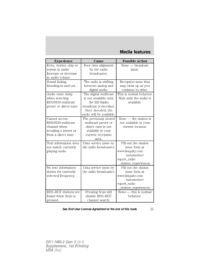
Page 57 of 89

Note:Your navigation SD card MUST be in the SD card slot in order for
you to access the navigation features.
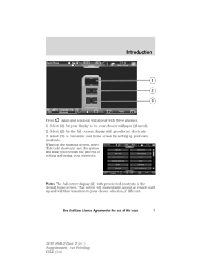
Your navigation system is comprised of two main features,")
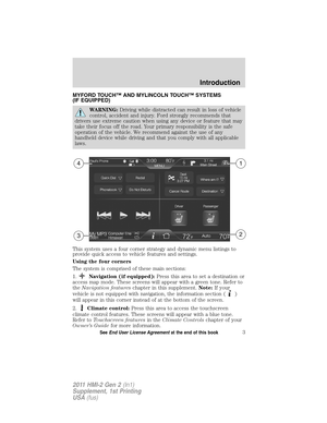
NAVIGATION FEATURES (IF EQUIPPED)
Note:Your navigation SD card MUST be in the SD card slot in order for
you to access the navigation features.
Your navigation system is comprised of two main features, destination
mode and map mode.
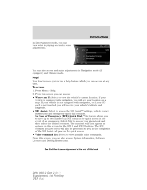
To set a destination, press Dest in the upper right hand corner of the
touchscreen. Then, refer toSetting a destinationwhich follows.
To view the navigation map and the vehicle’s current location,
touch the green bar in the upper right hand corner of the touchscreen.
Or, you can also press Dest > Map. Refer toMap modelater in this
section.
To order replacement SD navigation cards,see your authorized
dealer.
Note:Your SD card slot is spring loaded. To remove the SD card, simply
press the card in and the system will eject the card. Do not attempt to
pull the card to remove it as this could cause damage.
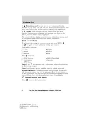
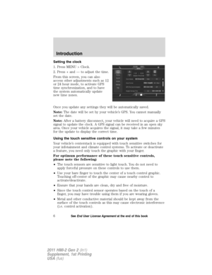
SETTING A DESTINATION
To set a destination:
1. Press ‘Dest’ on the top right corner of the screen.
2. Choose to set a destination using any of the following:
•My Home•Street Address
•Favorites•Intersection
•Previous Destinations•City Center
•Point of Interest (POI)•Map
•Emergency
3. Follow the highlighted text fields to enter any necessary information.
Note that any order of entry is acceptable. For address destination entry,
the Go! button will appear once all the necessary information has been
entered. Pressing the Go! button will trigger the display of the address
location on the map.
4. Select ‘Set as Dest’ to make this your destination. You can choose to
‘Set as Waypoint’ to have the system route to this point on the way to
your current destination. You can also choose to save the destination as a
Favorite.
Note:Any Avoid Areas which have been selected are also considered in
route calculation.
Navigation features
56SeeEnd User License Agreementat the end of this book
2011 HMI-2 Gen 2(ln1)
Supplement, 1st Printing
USA(fus)
Page 58 of 89

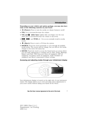
5. Now choose from up to three different routes based on route length
and estimated times of arrival:
•Fastest: Uses the fastest moving roads possible.
•Shortest: Uses the shortest distance possible.
•Eco (EcoRoute): Uses the most fuel efficient route.
6. Select ‘Start Route’.
You can also choose to cancel the route or to have the system demo the
route for you. Select ‘Route Prefs’ to set route preferences such as
having the system avoid freeways, toll roads, ferries and car trains as
well as to use or not use HOV lanes. (HOV lanes are High Occupancy
Vehicle Lanes also known as carpool or diamond lanes. These lanes are
reserved for people who ride in buses, vanpools or carpools.)
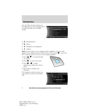
POI categories
Your system offers a variety if POI (Points of Interest) categories.
The main categories are as follows:
•Food / drink & dining•Automotive
•Travel & transportation•Shopping
•Financial•Entertainment & arts
•Emergency•Recreation & sports
•Community•Government
•Health & medicine•Domestic services
Within these main categories, you will find subcategories which contain
more listings. They subcategories are as follows:
•Restaurant•Auto Dealership
•Golf•Govt. Office
•Parking•Public Transit
•Home & Garden•Education
•Personal Care Services
To expand these listings, simply press the + in front of the POI listing.
The system also allows you to sort the POIs by distance, alphabetically
or by WCities listings (if available).
Navigation features
57SeeEnd User License Agreementat the end of this book
2011 HMI-2 Gen 2(ln1)
Supplement, 1st Printing
USA(fus)
Page 59 of 89
WCities (if available)
WCities is a service which provides
additional information about certain
points of interest (POIs) such as
restaurants, hotels and attractions
(if available).
Note:WCities POI information is
limited to approximately 100 cities
(92 U.S. cities and eight Canadian).
When you have selected a POI, the
location and information will appear,
such as address and phone number.
If the POI is listed with WCities, you
will also see information such as a
brief description, check in /out
times, when the restaurant is open,
etc.
Press ‘More Information’ for a longer
review, a list of services and
facilities, the average room or meal
price as well as the website (if available).
This screen will display the POI icon such as:
Hotel
Coffeehouse
Food & Drink
Navigation features
58SeeEnd User License Agreementat the end of this book
2011 HMI-2 Gen 2(ln1)
Supplement, 1st Printing
USA(fus)
Page 60 of 89

Nightlife
Attraction
This icon will appear when your
selection exists in multiple
categories within the system.
When you are viewing additional information for Hotels, WCities will also
tell you if the hotel has certain services and facilities using icons:
•
Restaurant•24 hr room service
•
Business center•Fitness center
•
Handicap facilities•Internet access
•
Laundry•Pool
•
Refrigerator•Wi-Fi
For restaurants,WCities can provide information such as star rating,
average cost, review, handicap access, hours of operation, and website
address.
For hotels,WCities can provide information such as star rating, price
category, review, check in/out times, hotel service icons and website
address.
Setting your navigation preferences
Your touchscreen system allows you to choose and set preferences which
the system will take into account when planning your route.
•Press Menu > Settings > Navigation to access:
•Map Preferences•Route Preferences
•Navigation Preferences•Traffic Preferences
•Avoid Areas
Navigation features
59SeeEnd User License Agreementat the end of this book
2011 HMI-2 Gen 2(ln1)
Supplement, 1st Printing
USA(fus)
Page 61 of 89
 ,
as well as setting the automatic
parking POI notification. If")
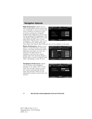
Map Preferences:Allows you to
turn breadcrumbs on/off, select how
you would like to view your turn list
(top to bottom or bottom to top) ,
as well as setting the automatic
parking POI notification. If you turn
on the parking POI notification, this
will display parking POI icons on the
map when you get close to your
destination. This feature may not be
as useful in very dense areas, and
may clutter the map if other POIs are also set for display on the map.
Route Preferences:Allows you to
select to avoid freeways, toll roads,
ferries, car trains and tunnels when
planning your route. You can also
select to use HOV lanes (if
available), and have the system
always select the shortest distance,
fastest time or most ecological route
when calculating a route for you.
Navigation Preferences:Allows
you to choose your navigation
prompts to be either voice or tone
only. You can also choose to have
the system automatically fill the
state and province based on the
information already entered into the
system.
Navigation features
60SeeEnd User License Agreementat the end of this book
2011 HMI-2 Gen 2(ln1)
Supplement, 1st Printing
USA(fus)
Page 62 of 89

Traffic Preferences:The Avoid Traffic Problems setting allows you to
set how you would like the system to handle traffic problems along your
route. Choose ‘Automatic’ for the system to automatically reroute you to
avoid traffic incidents that develop and impact the current route (no
notification is provided). Choose ‘Manual’ for the system to always
provide a traffic alert notification for traffic incidents along the planned
route. You will have a choice to accept or ignore the notification before
the route deviation is made.
You can also activate the display of certain or all traffic icons on the map
(road work, incidents, accidents, closed roads, weather related icons) by
choosing on or off.
Avoid Areas:Allows you to select areas which you would like the
system to avoid when calculating a route for you. Press ‘Add’ to add a
location from one of these categories to your avoid list:
•My Home•Street Address
•Favorites•Intersection
•Previous Destinations•City Center
•Point of Interest (POI)•Map
•Emergency
Once an avoid area is added, the system will try to avoid the area(s) if
possible for all routes. To delete an avoid area, select its listing on the
screen and when the screen changes to the Avoid Areas Edit screen
(avoid area is displayed on a map) press the Delete button at the bottom
right of the screen.
MAP MODE
To access map mode, press the green bar in the upper right area of the
touchscreen. The map screen will display.
Your system offers advanced map viewing comprised of both 2D city
maps as well as 3D landmarks (when available).
2D city mapsshow detailed outlines of buildings, visible land use and
land elements and detailed railway infrastructure for the most essential
cities around the globe. These 2D city maps also contain primary
features such as town blocks, building footprints, and railways.
Navigation features
61SeeEnd User License Agreementat the end of this book
2011 HMI-2 Gen 2(ln1)
Supplement, 1st Printing
USA(fus)
Page 63 of 89

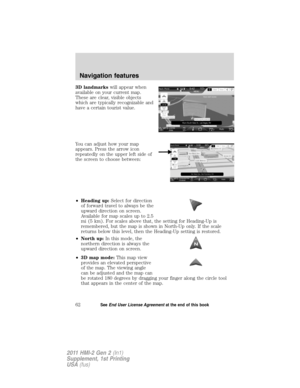
3D landmarkswill appear when
available on your current map.
These are clear, visible objects
which are typically recognizable and
have a certain tourist value.
You can adjust how your map
appears. Press the arrow icon
repeatedly on the upper left side of
the screen to choose between:
•Heading up:Select for direction
of forward travel to always be the
upward direction on screen.
Available for map scales up to 2.5
mi (5 km). For scales above that, the setting for Heading-Up is
remembered, but the map is shown in North-Up only. If the scale
returns below this level, then the Heading-Up setting is restored.
•North up:In this mode, the
northern direction is always the
upward direction on screen.
•3D map mode:This map view
provides an elevated perspective
of the map. The viewing angle
can be adjusted and the map can
be rotated 180 degrees by dragging your finger along the circle tool
that appears in the center of the map.
Navigation features
62SeeEnd User License Agreementat the end of this book
2011 HMI-2 Gen 2(ln1)
Supplement, 1st Printing
USA(fus)
Page 64 of 89

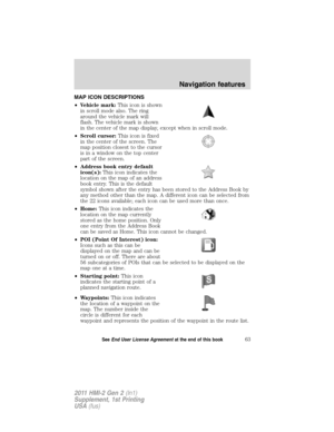
MAP ICON DESCRIPTIONS
•Vehicle mark:This icon is shown
in scroll mode also. The ring
around the vehicle mark will
flash. The vehicle mark is shown
in the center of the map display, except when in scroll mode.
•Scroll cursor:This icon is fixed
in the center of the screen. The
map position closest to the cursor
is in a window on the top center
part of the screen.
•Address book entry default
icon(s):This icon indicates the
location on the map of an address
book entry. This is the default
symbol shown after the entry has been stored to the Address Book by
any method other than the map. A different icon can be selected from
the 22 icons available; each icon can be used more than once.
•Home:This icon indicates the
location on the map currently
stored as the home position. Only
one entry from the Address Book
can be saved as Home. This icon cannot be changed.
•POI (Point Of Interest) icon:
Icons such as this can be
displayed on the map and can be
turned on or off. There are about
56 subcategories of POIs that can be selected to be displayed on the
map one at a time.
•Starting point:This icon
indicates the starting point of a
planned navigation route.
•Waypoints:This icon indicates
the location of a waypoint on the
map. The number inside the
circle is different for each
waypoint and represents the position of the waypoint in the route list.
Navigation features
63SeeEnd User License Agreementat the end of this book
2011 HMI-2 Gen 2(ln1)
Supplement, 1st Printing
USA(fus)


WCities is a service which provides
additional information about certain
points of interest (POIs) such as
restaurants, hotels and attractions
(if available).
Note:WCities POI i")