Page 1 of 151

Navigation System1
Table of Contents
Introduction .................................. 4
Manual Overview ............................ 4
System Overview ............................ 4
Accessories Precautions .................. 5
Important Safety Information .......... 5
Map Overview ................................. 6
Current Street .................................... 6
Verified/Unverified Street .................. 6
User Agreement ............................8
Getting Started ........................... 10
System Controls ............................ 10
Voice Control Basics ..................... 12
Using the Voice Control System ...... 13
Improving Voice Rec ognition ..........13
Selecting an Item (Button) on the
Screen ......................................... 14
Selecting an Item in a List ............. 14
Using the On-screen Keyboard ..... 15
System Start-up ............................. 16
Map Screen Legend ....................... 18
Map Screen Description ................ 19
Zoom In/Out..................................... 19
Map Scrolling .................................. 19
Displaying Current Location .........19
System Function Diagram ............. 20
Entering a Destination ..............21
By Address .................................... 22
Selecting the State or Province ........ 22
Selecting the City ............................. 22
Selecting the Street .......................... 24
Entering the Street Number ............. 26
By Intersection...............................26
Selecting the State or Province ........ 27
Selecting the City ............................. 27
Selecting the Street .......................... 29
By Places .......................................31
Finding the Place by Category ........ 32
Finding the Place by Name.............. 35
Finding the Place by Phone Number ......................................... 36
By Map Input ................................. 36
Showing the Map of Current
Position......................................... 36
Showing the Map of City ..................38
Showing the Map of Stat e ................38
Showing the Map of Continental USA............................................... 39
By Previous Destinations............... 40
By Today’s Destinations ............... 41
Editing Today’s Destinations List ...41
Adding Destinations to the List........ 41
By Address Book ...........................42
Adding Addresses to the Personal
Address Book ................................ 43
By Go Home .................................. 43
Driving to Your Destination .....45
Driving to Your Destination .......... 45
Calculate Route to Screen.............. 45
Changing the Routing Method ......... 46
Viewing the Routes........................... 47
Viewing the Destination Map .......... 48
Map Screen ....................................48
Route Line ........................................ 48
Guidance Prompts ...... ..................... 49
Map Screen Legend ......................... 50
Guidance Screen ............................51
Guidance Screen Legend.................51
Distance and Time to
Destination .................................. 52
Direction List ................................. 52
Exit Info.
(Freeway Exit Information) .......... 53
Guidance Mode.............................. 53
Map Scale ...................................... 54
Map Orientation ............................. 55
Destination Icon ............................. 55
00X31-TK6-8100
\251 2009 American Honda Motor Co., Inc. - All Rights Reserved
2010 Fit
Page 2 of 151

2Navigation System
Table of Contents
Landmark Icons .............................56
Showing Icons on the Map............... 58
Icon Options .................................... 58
Going Off the Route ......................60
Off-road Tracking.......................... 60
Viewing/Saving the Current Location ...................................... 61
Pop-Ups and Disclaimers .............. 62
Changing the Route ....................... 63
Change Route By Screen ................. 63
Waypoints ........................................ 63
Reroute: Avoid Streets ..................... 65
Reroute: Detour ............................... 65
Reroute: Change Routing Method ... 65
Cancel Current Route ...................... 66
Back to Current Route ..................... 66
Changing Your Destination ...........66
Find Nearest (Voice command) .......66
Go Home (Voice command) ............ 66
Using Joystick to Change Destination ................................... 66
Entering a Destination from the Menu Screen (while en route) ................ 68
Continue Trip Screen..................... 68
Information Features ................69
Information Screen ........................ 69
Voice Command Help ................... 69
Map Legend ................................... 70
Calendar ......................................... 70
Entering Your Schedule ................... 71
Calculator.......................................72
Unit Conversion ............................... 72
System Setup ..............................73
Setup Mode .................................... 73
Setup Screen (first) ........................ 73
Brightness ........................................ 73
Volume ............................................. 73
Display ............................................. 74
Guidance Prompts ....... .................... 75
Contrast ........................................... 75
Setup Screen (second) ...................76
Personal Information ..................... 76
Address Book ................................... 76
Home Address .................................. 80
PIN Number ..................................... 80
User Name ....................................... 81
Previous Destinations ...................... 81
Routing & Guidance ......................82
Rerouting ......................................... 82
Unverified Area Routing .................. 83
Edit Avoid Area................................ 87Edit Waypoint Search Area..............
89
Guidance Mode .... ............................90
Vehicle ........................................... 90
Off-road Tracking............................90
Correct Vehicle Position.................. 91
System Information .......................92
Basic Settings................................. 92
Keyboard Layout..............................92
Units (mile or km) ............................ 92
Voice Recognition Fe edback ...........92
Clock Settings ................................ 93
Clock Adjustment ............................. 93
Clock Type ....................................... 94
Color ..............................................95
Map Color ........................................ 95
Menu Color ...................................... 95
System Initialization ..................96
System Initialization ......................96
Entering the Security Code ............ 96
GPS Initialization ...........................97
Map Matching................................ 97
System Limitations ....................98
Database Limitations............... 100
2010 Fit
Page 3 of 151

Navigation System3
Table of Contents
Customer Assistance ................ 102
Reporting Errors .......................... 102
Honda Automobile Customer Service ...................................... 102
Visiting Your Dealer ................... 103
Obtaining a Navigation Update DVD ......................................... 103
Changing the DVD ...................... 104
PC Card Operation ...................... 105
Inserting the PC Card.................... 105
Voice Control of PC Card Functions .................................... 105
CD/CD-R Operation .................... 105
Voice Control of CD Functions ..... 106
Coverage Areas .........................107
Map Coverage ............................. 107
U.S. Detailed Coverage Areas....... 107
Canada Detailed Coverage Areas .......................................... 112
Operation in Alaska and
Hawaii ...................................... 121
Alaska ............................................ 121
Hawaii ........................................... 121
Shipping a Vehicle To or From Hawaii ........................................ 122
Frequently Asked
Questions ............................... 123
Troubleshooting ....................... 133
Glossary .................................... 135
Glossary ....................................... 135
Voice Command Index ............138
Global Commands ....................... 138
Navigation General Commands ................................ 138
Navigation Display Commands ................................ 139
Find Place Commands ................. 140
Radio Voice Commands .............. 141
CD Voice Commands .................. 142
PC Card Voice Commands .......... 142
AUX Voice Commands ............... 142
Information Screen Voice Commands ................................ 143
Setup Screen (first) Commands ................................ 143
On-Screen Commands ................. 144
On-Screen Commands Assist ......... 144
Index .........................................146
2010 Fit
Page 4 of 151

4Navigation System
Introduction
Manual Overview
The manual is divided into the
following sections:
• Getting Started - A basic introduction that discusses the controls and how to
communicate with the system.
• Entering a Destination - How to enter an address or locate a point of interest
(POI).
• Driving to Your Destination - An explanation of the map features,
guidance, and cautions.
• Information Features - Voice Command Help, Map Legend,
Calendar, and Calculator.
• System Setup - How to set up and tailor the system for your personal
use and use the Address Book. The back of this manual contains:
• Map Coverage (page
107)
• Frequently Asked Questions (FAQs) (page 123)
• Troubleshooting Guide (page 133)
• Glossary of Terms (page 135)
• Voice Command List (page 138)
• Operation Specific to Alaska and Hawaii (page 121)
System Overview
Your navigation system is a highly
sophisticated location system with voice
control that uses satellites and a map
database to show you where you are and
to help guide you to a desired
destination.
The navigation system receives signals
from the global positioning system
(GPS), a network of 24 satellites in orbit
around the earth. By receiving signals
from several of these satellites, the
navigation system can determine the
latitude, longitude, and elevation of
your vehicle. In a ddition, a gyroscopic
yaw sensor and a vehicle speed sensor
in your vehicle k eep track of the
direction and speed of travel at all times.
2010 Fit
Page 5 of 151

Navigation System5
Introduction
The navigation system applies this
location, direction, and speed
information to the maps and calculates a
route to the destination you enter. As
you drive to that destination, the system
provides map and voice guidance.
The navigation system is easy to use.
The locations of many places of
business and entertainment are already
entered in the system. You can select
any of them as a destination by using the
touch screen, joystick, or voice control.
There are several ways to enter a
destination, such as by point of interest
(POI), by address, by phone number,
and by selecting it from the map. The
last 50 destinations are saved for reuse
at a later date. The system also allows
you to store a home address to simplify
returning home from your destination.Accessories Precautions
If you have front or side window tinting
installed, be aware that if the tint has
metallic properties, it can seriously
degrade or prevent GPS reception. This
is because the GPS antenna is located
under the dashboard.
If you plan to install electronic
components, such as radar detectors,
vehicle tracking devices, remote
starters, additional amplifiers, or other
audio components, ensure that they are
not located near the navigation control
unit under the dashboard, near the
navigation screen in the dash, or near
the GPS antenna under the dashboard.
Signal noise emanating from these
devices can cause intermittent
disruption of the navigation system.
Important Safety Information
The navigation system can distract your
attention from the road if you focus on
the screen or operate the system’s
controls while driving.
Enter as much information as possible
into the system before you begin
driving, or when the vehicle is stopped.
Then, as you drive, listen to the audio
instructions and use voice commands
when possible.
2010 Fit
Page 6 of 151

6Navigation System
While driving, do not look at the screen
or operate the system controls for more
than a second or so at a time, and only
after deciding you can do so safely. Pull
to the side of the road if you need more
time to look at the screen or operate the
controls. The navigation system is designed to
provide route information to help you
reach your destination. However, this
route guidance may sometimes conflict
with current road conditions such as
street closures, road construction,
detours, and out-of-date map data.
Additionally, the system itself has
certain limitations (see page
98).
Therefore, you must verify the audio
and visual route information provided
by the system by caref ully observing the
roadway, signs and signals, etc. If you
are unsure, proceed with caution.
Always use your own good judgment,
and obey traffic laws while driving.
Map Overview
Current Street
The current street on which your vehicle
is located appears at the bottom of the
map screen (see page 18). A message
saying
“Not on a digitized road” may
appear instead when you drive half a
mile away from a mapped road. For
more details, see Off-road Tracking on
page 60.
Verified/Unverified Street
Your navigation system has two kinds
of streets: verified (dark colored) and
unverified (light colored). The
differences between the two types of
streets are contrasted in the chart on
page 7.
Using the navigation system
while driving can take your
attention away from the road,
causing a crash in which you
could be seriously injured or
killed.
Follow all operating instructions
and safety information in this
manual.
WARNING
“Unverified” Road
“Verified” Road
Introduction
2010 Fit
Page 7 of 151
 Unverified streets (light colored)
When
displayed These roads are found within
metropolitan areas, and
include interstate freeways")
Navigation System7
Introduction
Verified streets (dark colored) Unverified streets (light colored)
When
displayed These roads are found within
metropolitan areas, and
include interstate freeways and major roads
connecting cities. These roads are found in rural
areas, and typically include
residential street s away from the center of a town.
Street color Shown on daytime
map screen as black or red, such as
interstate freeways. Shown on the daytime
map screen as light brown.
Map quality The database vendor has
verified these streets.
Information like tu rn restrictions, average speed, and
whether it is a one-way street have been gathered and
used when creating your route to a destination. These streets have not been veri
fied by the database vendor. The
system does not contain inform ation on one-way streets, turn
restrictions, or the road’s average speed. They are shown on the
map for reference and may have e rrors in map location, naming,
and address range.
Routing
differences While driving to your destin
ation, the displayed route
line is solid blue. The sy stem provides voice and map
guidance to your destination. Your route line is either a blue
dotted “vector line,” or a dashed
pink/blue line. For information on selecting this option, and the
routing differences, see Unverified Area Routing on page83.
Cautions There are no pop-up boxes urging extra caution during
a route. However, because roads constantly change,
you are urged to use common
sense, and always obey
posted traffic restrictions. Regardless of whether the user c
hooses route guidance, there are
cautionary screens before and dur ing the route urging the user to
be extra cautious, and obey a ll traffic restrictions. See Unverified
Area Routing on page83.
Guidance
voice Voice guidance issues instruct
ions such as “In a half-
mile, make a right turn.” The phrase “if possible” is added
to each guidance instruction.
For example: “In a half-mile, ma ke a right turn, if possible.”
Time and
distance
“to go” The time and distance “t
o go,” displayed while en
route to a destination, is based on the average speed
and distance for the roads used for your route. Because the average speed of thes
e roads is not known, the time
and distance “to go” is based on a fixed average speed of 25 mph
for these roads.
2010 Fit
Page 8 of 151
,
which includes HONDA MOTOR CO.,
LTD. software, ALPINE
ELECTRONICS, INC. software,
NAV")
8Navigation System
User Agreement
In using this DVD “Satellite Linked
Navigation System” (the “DVD”),
which includes HONDA MOTOR CO.,
LTD. software, ALPINE
ELECTRONICS, INC. software,
NAVTEQ database contents, INFO
USA CORPORATION database, and
ZENRIN CO. database contents
(hereinafter referred to as “Licensors”),
you are bound by the terms and
conditions set forth below.
By using your copy of the DVD, you
have expressed your Agreement to the
terms and conditions of this Agreement.
You should, therefore, make sure that
you read and understand the following
provisions. If for any reason you do not
wish to be bound by the terms of this
Agreement, please return the DVD to
your dealer. • The DVD may not be copied,
duplicated, or otherwise modified, in
whole or in part, without the express
written permission of the Licensors.
• The DVD may not be transferred or sublicensed to any third party for
profit, rent or loan, or licensed for
reuse in any manner.
• The DVD may not be decompiled, reverse engineered or otherwise
disassembled, in whole or in part.
• The DVD may not be used in a network or by any other manner of
simultaneous use in multiple systems.
• The DVD is intended solely for personal use (or internal use where
the end-user is a business) by the
consumer. The DVD is not to be used
for commercial purposes. • The Licensors do not guarantee to the
customer that the functions included
in the DVD meet the specific
objectives of the user.
• Licensor shall not be responsible for any damages caused by the use of the
DVD to the actual user or to any third
party.
• The warranty on the DVD shall not extend to an exchange or refund due
to misspelling, omission of letters, or
any other cosmetic discrepancy in the
contents of the DVD.
• The right to use the DVD shall expire either when the user destroys the
DVD or software, or when any of the
terms of this Agreement are violated
and the Licensors exercise the option
to revoke the license to use the DVD
or software.
2010 Fit
 1
1 2
2 3
3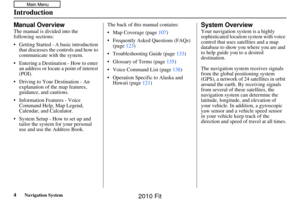 4
4 5
5 6
6 7
7 8
8 9
9 10
10 11
11 12
12 13
13 14
14 15
15 16
16 17
17 18
18 19
19 20
20 21
21 22
22 23
23 24
24 25
25 26
26 27
27 28
28 29
29 30
30 31
31 32
32 33
33 34
34 35
35 36
36 37
37 38
38 39
39 40
40 41
41 42
42 43
43 44
44 45
45 46
46 47
47 48
48 49
49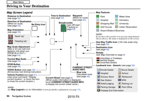 50
50 51
51 52
52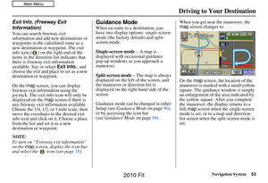 53
53 54
54 55
55 56
56 57
57 58
58 59
59 60
60 61
61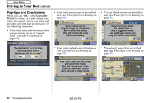 62
62 63
63 64
64 65
65 66
66 67
67 68
68 69
69 70
70 71
71 72
72 73
73 74
74 75
75 76
76 77
77 78
78 79
79 80
80 81
81 82
82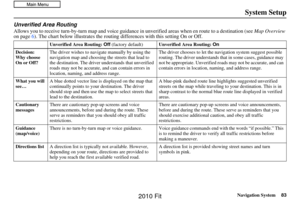 83
83 84
84 85
85 86
86 87
87 88
88 89
89 90
90 91
91 92
92 93
93 94
94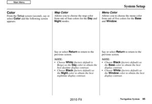 95
95 96
96 97
97 98
98 99
99 100
100 101
101 102
102 103
103 104
104 105
105 106
106 107
107 108
108 109
109 110
110 111
111 112
112 113
113 114
114 115
115 116
116 117
117 118
118 119
119 120
120 121
121 122
122 123
123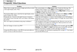 124
124 125
125 126
126 127
127 128
128 129
129 130
130 131
131 132
132 133
133 134
134 135
135 136
136 137
137 138
138 139
139 140
140 141
141 142
142 143
143 144
144 145
145 146
146 147
147 148
148 149
149 150
150