2008 NISSAN XTERRA change time
[x] Cancel search: change timePage 148 of 217
Black plate (153,1)
Model "NAV2-N" EDITED: 2007/ 3/ 9
Available setting items
.Display:
Allows you to turn on/off the screen.
“DISPLAY” (page 8-3)
.Brightness:
Allows you to adjust the screen brightness.
“BRIGHTNESS” (page 8-3)
.Contrast:
Allows you to adjust the screen contrast.
“CONTRAST” (page 8-3)
.Background Color:
Allows you to set the background color.
“BACKGROUND COLOR”
(page 8-3)
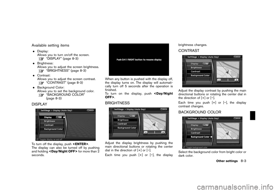
DISPLAY
To turn off the display, push
The display can also be turned off by pushing
and holding
seconds.
When any button is pushed with the display off,
the display turns on. The display will automati-
cally turn off 5 seconds after the operation is
finished.
To t u r n o n t h e d i s p l a y, p u s h
BRIGHTNESS
Adjust the display brightness by pushing the
main directional buttons or rotating the center
dial in the direction of [+] or [−].
Each time you push [+] or [−], the displaybrightness changes.
CONTRAST
Adjust the display contrast by pushing the main
directional buttons or rotating the center dial in
the direction of [+] or [−].
Each time you push [+] or [−], the display
contrast changes.
BACKGROUND COLOR
Select the background color from bright color or
dark color.
Other settings8-3
Page 150 of 217
Black plate (155,1)
Model "NAV2-N" EDITED: 2007/ 3/ 9
“CUSTOMIZING NEARBY PLACES”
(page 8-5)
.Map Scrolling Information:
Performs the setting so that when the map is
scrolled, the information of the location
aligned at the center of the cross pointer is
displayed.
“MAP SCROLLING INFORMATION”
(page 3-20)
.Map Color Settings:
Switches the map color.
“MAP COLOR SETTINGS”
(page 8-6)
.Audio Display on Map:
Allows the AV information to be displayed at
all times.
“DISPLAYING THE AV INFORMA-
TION ON THE MAP SCREEN”
(page 8-6)
.Keyboard Input:
Switches the keyboard layout for the char-
acter input screen.
“SETTINGS THE KEYBOARD LAY-
OUT OF THE CHARACTER INPUT
SCREEN” (page 8-7)
.Small Step Zoom by Dial:
Sets the ON/OFF of the free zoom function.
When this setting is ON, it is possible to
adjust the scale in smaller steps than withnormal scale adjustment.
.Auto North Up Zoom:
When this setting is ON, the orientation of
the map is automatically changed to North
Up when the widest map scale is selected.
The orientation is changed to North Up even
when Heading Up is set.
.Adjust Current Location:
Corrects the position of current location.
“ADJUSTING THE CURRENT VEHI-
CLE LOCATION” (page 8-7)
.Reset ALL Navigation Settings to Default:
Resets all of the settings to default.
“RESET ALL NAVIGATION SET-
TINGS TO DEFAULT” (page 8-8)
CUSTOMIZING NEARBY PLACES
You can change the categories used for
searching Points of Interest nearby.
The modified list of Points of Interest can be
used for searching for a location using [Nearby
Places].
“SETTING A NEARBY PLACE”
(page 4-14)
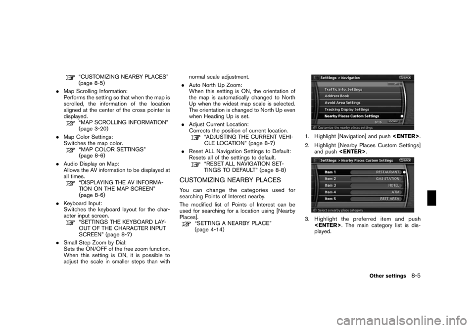
1. Highlight [Navigation] and push
2. Highlight [Nearby Places Custom Settings]
and push
3. Highlight the preferred item and push
played.
Other settings8-5
Page 155 of 217
Black plate (160,1)
Model "NAV2-N" EDITED: 2007/ 3/ 9
when the beep function is set to on. The
beep that sounds when pushing and holding
a button or when a prohibited operation is
performed cannot be set to off.
INFO:
For more details about [Ringer Vol.], [Incoming
Call] and [Outgoing Call], refer to the vehicle
Owner’s Manual.This allows you to change the clock settings.
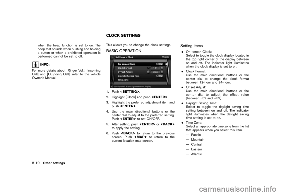
BASIC OPERATION
1. Push
2. Highlight [Clock] and push
3. Highlight the preferred adjustment item and
push
4. Use the main directional buttons or the
center dial to adjust to the preferred setting.
Push
5. After setting, push
to apply the setting.
6. Push
screen. Push
Page 171 of 217
Black plate (178,1)
Model "NAV2-N" EDITED: 2007/ 3/ 9
VOICE COMMAND EXAMPLES
To use the voice recognition function, speaking
one command is sometimes sufficient, but at
other times it is necessary to speak two or more
commands. As examples, some additional basic
operations by voice commands are described
here.
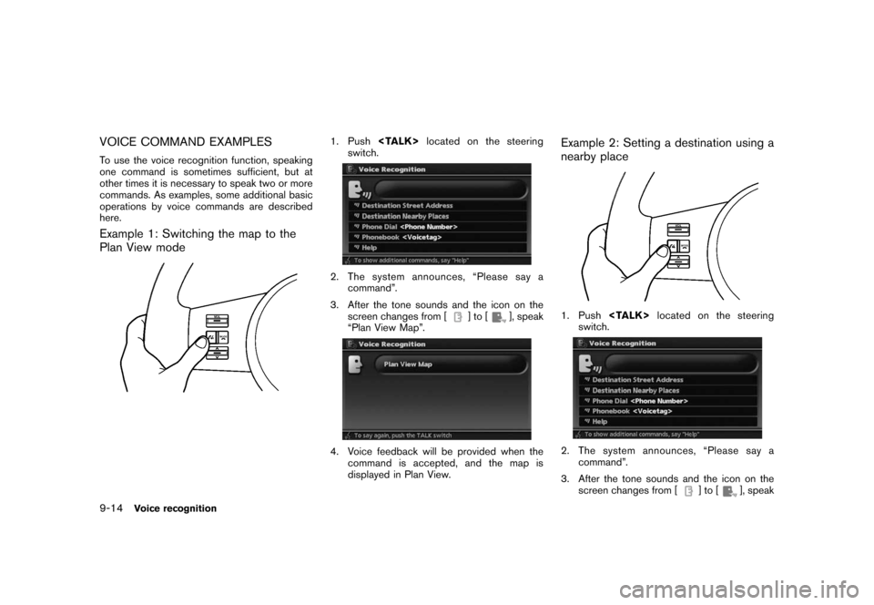
Example 1: Switching the map to the
Plan View mode
1. Push
switch.
2. The system announces, “Please say a
command”.
3. After the tone sounds and the icon on the
screen changes from [
]to[], speak
“Plan View Map”.
4. Voice feedback will be provided when the
command is accepted, and the map is
displayed in Plan View.
Example 2: Setting a destination using a
nearby place
1. Push
switch.
2. The system announces, “Please say a
command”.
3. After the tone sounds and the icon on the
screen changes from [
]to[], speak
9-14Voice recognition
Page 184 of 217
Black plate (191,1)
Model "NAV2-N" EDITED: 2007/ 3/ 9
— If the destination, current vehicle position
or waypoint is within the “Avoid Area”.
— If a part of the route is included in the
“Avoid Area”.
.The following may occur when the route is
displayed.
— If you calculate a route on a main road,
the starting point of the route may not
exactly match the current vehicle loca-
tion.
— The endpoint of the route may not
exactly match the destination.
— If you calculate a route on a main road,
the system may display a route from
another main road. This may be because
the position of the vehicle icon is not
accurate. In this case, park the vehicle in
a safe location and reset the vehicle
icon, or continue driving to see if the
position of the vehicle icon is automati-
cally adjusted before recalculating the
route.
— There are cases in which the system
shows an indirect route to reach the
destination or waypoints, if you set them
from stored or facility information. In
order to correct this, you must be careful
about the traffic direction, especially
when lanes with different travel direc-tions are shown separately, such as
interchanges and service areas.
— This system makes no distinction be-
tween limited traffic control and total
control (blockage) . It may show an
indirect route even if the road is usable.
— Even if the freeway preference is set to
OFF, a route that uses the freeway may
be suggested.
— Even if the preference is set to OFF, a
route that uses a ferry line may be
suggested.
— Ferry lines, excluding those that are only
for pedestrians, bicycles and motor-
cycles, are stored in this system. Take
into consideration the travel time re-
quired and operational condition before
deciding whether to use them or not.INFO:
The announcement of the street name during
route guidance is available only when English is
set as the language for the system. Street
names are not announced if French is set for the
system.
BASICS OF VOICE GUIDANCE
Voice guidance announces which direction to
turn when approaching an intersection in which
a turn is necessary.
NOTE:
.There may be some cases in which
voice guidance and actual road condi-
tions do not correspond. This may
occur because of discrepancies be-
tween the actual road and the informa-
tion on the map data, or it is due to the
vehicle’s speed.
.In case voice guidance does not corre-
spond to the actual road conditions,
follow the information obtained from
traffic signs or notices on the road.
ROUTE GUIDANCE
General system information10-9
Page 188 of 217
Black plate (195,1)
Model "NAV2-N" EDITED: 2007/ 3/ 9
.Because it is not possible to consider data
concerning roads that are seasonally avail-
able or unavailable, a route may be displayed
that does not match the actual traffic
restrictions. Be sure to follow the actual
traffic restrictions while driving.
.Canada and Alaska contain many roads with
incomplete map data. As a result, when
searching for a route, the route may include
roads with incomplete data. In regions
where road data is not complete, voice
guidance may stop for long periods of time.
Be sure to follow the actual traffic restric-
tions while driving..The XM®NavTrafficTMinformation service is
not provided for some cities. In addition, the
cities for which the traffic information service
is provided may be changed.
.In some cases, infrastructure problems may
prevent the complete display of the traffic
information. This is not a malfunction.
.Due to infrastructure problems, or due to the
time when the traffic information service
broadcast is received, the displayed infor-
mation may differ from the actual traffic
conditions.
.Depending on the traffic information, a
detour route may be slower than the original
route.
.XM
®NavTrafficTMis a service of XM®
Satellite Radio. XM®NavTrafficTMis only
available in select markets within the 48
contiguous United States and is subject to
data availability. Reception of the XM
®signal
may vary depending on location. It requires a
monthly premium subscription. The service
provider is solely responsible for the quality
and accuracy of the information provided. All
fees and programming are subject to
change. For more details on the XM
®
NavTrafficTMservice, terms and conditions,
please visit
www.xmradio.com.
You can also contact XM
®Radio at1-800-XM-RADIO (1-800-967-2346) .
.As of June 14, 2006, traffic information for
the following cities is covered by XM
®
NavTrafficTM. However, coverage may
change. For the latest coverage, please
refer to
www.xmradio.com/xmnavtraffic, or call XM
®
Radio customer support at
1-800-XM-RADIO (1-800-967-2346) .
— Atlanta, GA
— Baltimore, MD*
— Boston, MA
— Chicago, IL
— Cincinnati, OH*
— Cleveland, OH*
— Dallas - Ft. Worth, TX*
— Denver - Boulder, CO*
— Detroit, MI
— Houston - Galveston, TX
— Los Angeles, CA
— Miami - Ft. Lauderdale - Hollywood, FL*
— Milwaukee - Racine, WI
— Minneapolis - St. Paul, MN
— New York, NY
— Orlando, FL*
— Philadelphia, PA
NOTES ON XM®NavTrafficTM
INFORMATION
General system information10-13