Page 137 of 156
OTHER FUNCTIONS
136
07/07/28GS460/350/450h_Navi_U
OM30875U
Page 138 of 156
SECTION6
APPENDIX
137
APPENDIX
DLimitations of the navigation system 138 ......................
D Map database information and updates 140
...................
07/07/28 GS460/350/450h_Navi_U
OM30875U
Page 139 of 156

APPENDIX
138
This navigation system calculates the
current vehicle position using satellite
signals, various vehicle signals, map
data, etc. However, the accurate posi-
tion may not be shown depending on
the satellite condition, road configura-
tion, vehicle condition or other circum-
stances.
The Global Positioning System (GPS) de-
veloped and operated by the U.S. Depart-
ment of Defense provides an accurate cur-
rent vehicle position, normally using 4 or
more satellites, and in some cases 3 satel-
lites. The GPS system has a certain level
of inaccuracy. While the navigation sys-
tem will compensate for this most of the
time, occasional positioning errors of up to
300 feet (100 m) can and should be expec-
ted. Generally, position errors will be cor-
rected within a few seconds.
When your vehicle is receiving signals
from the satellites, the “GPS” mark ap-
pears at the top left of the screen.
The GPS signal may be physically ob-
structed, leading to inaccurate vehicle
position on the map display. Tunnels, tall
buildings, trucks, or even the placement of
objects on the instrument panel may ob-
struct the GPS signals.
The GPS satellites may not send signals
due to repairs or improvements being
made to them.
Even when the navigation system is re-
ceiving clear GPS signals, the vehicle
position may not be shown accurately or
inappropriate route guidance may occur in
some cases.
NOTICE
The installation of window tinting
may obstruct the GPS signals. Most
window tinting contains some metal-
lic content that will interfere with GPS
signal reception of the antenna in the
instrument panel. We advise against
the use of window tinting on vehicles
equipped with navigation systems.
07/07/28GS460/350/450h_Navi_U
OM30875U
Limitations of the
navigation system
Page 140 of 156
 Accurate current vehicle position
may not be shown in the following
cases:
DWhen driving on a small angled Y−
shaped road.
DWhen driving on a winding road.
DWhen driving on a slippe")
APPENDIX
139
(a) Accurate current vehicle position
may not be shown in the following
cases:
DWhen driving on a small angled Y−
shaped road.
DWhen driving on a winding road.
DWhen driving on a slippery road such
as in sand, gravel, snow, etc.
DWhen driving on a long straight road.
DWhen freeway and surface streets run
in parallel.
DAfter moving by ferry or vehicle carrier.
DWhen a long route is searched during
high speed driving.
DWhen driving without setting the cur-
rent position calibration correctly.
DAfter repeating a change of direction by
going forward and backward, or turning
on a turntable in the parking lot.
DWhen leaving a covered parking lot or
parking garage.
DWhen a roof carrier is installed.
DWhen driving with tire chains installed.
DWhen the tires are worn.
DAfter replacing a tire or tires.
DWhen using tires that are smaller or
larger than the factory specifications.
DWhen the tire pressure in any of the
four tires is not correct.
INFORMATION
If your vehicle cannot receive GPS
signals, you can correct the current
position manually. For information
on setting the current position cal-
ibration, see page 112.
(b) Inappropriate route guidance may
occur in the following cases:
DWhen turning at an intersection off the
designated route guidance.
DIf you set more than one destination but
skip any of them, auto reroute will dis-
play a route returning to the destination
on the previous route.
DWhen turning at an intersection for
which there is no route guidance.
DWhen passing through an intersection
for which there is no route guidance.
DDuring auto reroute, the route guid-
ance may not be available for the next
turn to the right or left.
DIt may take a long time to operate auto
reroute during high speed driving. In
auto reroute, a detour route may be
shown.
DAfter auto reroute, the route may not be
changed.
DAn unnecessary U −turn may be shown
or announced.
DA location may have multiple names
and the system will announce one or
more.
DSome routes may not be searched.
DIf the route to your destination includes
gravel, unpaved roads or alleys, the
route guidance may not be shown.
DYour destination point might be shown
on the opposite side of the street.
DWhen a portion of the route has regula-
tions prohibiting the entry of the vehicle
that vary by time or season or other
reasons.
DThe road and map data stored in your
navigation system may not be com-
plete or may not be the latest version.
07/07/28 GS460/350/450h_Navi_U
OM30875U
Page 141 of 156

This navigation system uses tire turning
data and is designed to work wit")
APPENDIX
140
After replacing a tire, implement the op-
eration described in the “TIRE
CHANGE CALIBRATION”. (See page
113.)
This navigation system uses tire turning
data and is designed to work with factory−
specified tires for your vehicle. Installing
tires that are larger or smaller than the orig-
inally equipped diameter may cause inac-
curate display of the vehicle’s position.
The tire pressure also affects the diameter
of the tires so please make sure the tire
pressure of all four tires is correct. This system uses the maps of DENSO.
2007 DENSO CORPORATION
2006 NAVTEQ. All rights reserved.
2006 Tele Atlas North America, Inc.
All rights reserved. This material is pro-
prietary and the subject of copyright
protection and other intellectual prop-
erty rights owned by or licensed to Tele
Atlas North America, Inc. The use of
this material is subject to the terms of
a license agreement. You will be held
liable for any unauthorized copying or
disclosure of this material.
Data by infoUSA Copyright 2006, All
Rights Reserved.
2006 VISA Corporation
National Research Bureau 2006
The Bullseye Design is a registered
trademark of Target Brands, Inc.
07/07/28 GS460/350/450h_Navi_U
OM30875U
Map database information
and updates —
Page 142 of 156
 is provided for your
personal, internal use only and not for
resale. It is protected by copyright, and
is subject to the following terms and
conditi")
APPENDIX
141
END−USER TERMS
The data (“Data”) is provided for your
personal, internal use only and not for
resale. It is protected by copyright, and
is subject to the following terms and
conditions which are agreed to by you,
on the one hand, and DENSO
CORPORATION (“[CLIENT]”) and its
licensors (including their licensors and
suppliers) on the other hand.
2006 NAVTEQ. All rights reserved.
The Data for areas of Canada includes
information taken with permission from
Canadian authorities, including: Her
Majesty the Queen in Right of Canada,
Queen’s Printer for Ontario,
Canada Post Corporation,
GeoBase R.
NAVTEQ holds a non −exclusive li-
cense from the United States Postal
Service Rto publish and sell ZIP+4 R
information.
United States Postal Service 2006.
Prices are not established, controlled
or approved by the United States Post-
al Service R. The following trademarks
and registrations are owned by the
USPS: United States Postal Service,
USPS, and ZIP+4.TERMS ANDCONDITIONS
Personal Use Only
. You agree to use
this Data together with the navigation
system for the solely personal, non −
commercial purposes for which you
were licensed, and not for service bu-
reau, time− sharing or other similar pur-
poses. Accordingly, but subject to the
restrictions set forth in the following
paragraphs, you may copy this Data
only as necessary for your personal
use to (i) view it, and (ii) save it, pro-
vided that you do not remove any copy-
right notices that appear and do not
modify the Data in any way. You agree
not to otherwise reproduce, copy,
modify, decompile, disassemble or re-
verse engineer any portion of this
Data, and may not transfer or distribute
it in any form, for any purpose, except
to the extent permitted by mandatory
laws. Multi− disc sets may only be
transferred or sold as a complete set
as provided by [CLIENT] and not as a
subset thereof.
07/07/28 GS460/350/450h_Navi_U
OM30875U
Page 143 of 156
![Lexus GS350 2008 Navigation Manual APPENDIX
142
Restrictions.Except where you have
been specifically licensed to do so by
[CLIENT], and without limiting the pre-
ceding paragraph, you may not (a) use
this Data with any products, system](/manual-img/36/14338/w960_14338-142.png "Lexus GS350 2008 Navigation Manual APPENDIX
142
Restrictions.Except where you have
been specifically licensed to do so by
[CLIENT], and without limiting the pre-
ceding paragraph, you may not (a) use
this Data with any products, system")
APPENDIX
142
Restrictions.Except where you have
been specifically licensed to do so by
[CLIENT], and without limiting the pre-
ceding paragraph, you may not (a) use
this Data with any products, systems,
or applications installed or otherwise
connected to or in communication with
vehicles, capable of vehicle naviga-
tion, positioning, dispatch, real time
route guidance, fleet management or
similar applications; or (b) with or in
communication with any positioning
devices or any mobile or wireless −con-
nected electronic or computer devices,
including without limitation cellular
phones, palmtop and handheld com-
puters, pagers, and personal digital as-
sistants or PDAs.
Warning.
The Data may contain inac-
curate or incomplete information due
to the passage of time, changing cir-
cumstances, sources used and the na-
ture of collecting comprehensive geo-
graphic data, any of which may lead to
incorrect results.
No Warranty.
This Data is provided to
you “as is,” and you agree to use it at
your own risk. [CLIENT] and its licen-
sors (and their licensors and suppliers)
make no guarantees, representations
or warranties of any kind, express or
implied, arising by law or otherwise, in-
cluding but not limited to, content, qual-
ity, accuracy, completeness, effective-
ness, reliability, fitness for a particular
purpose, usefulness, use or results to
be obtained from this Data, or that the
Data or server will be uninterrupted or
error− free.
Disclaimer of Warranty:[CLIENT] AND
ITS LICENSORS (INCLUDING THEIR
LICENSORS AND SUPPLIERS) DIS-
CLAIM ANY WARRANTIES, EX-
PRESS OR IMPLIED, OF QUALITY,
PERFORMANCE, MERCHANTABIL-
ITY, FITNESS FOR A PARTICULAR
PURPOSE OR NON− INFRINGE-
MENT. Some States, Territories and
Countries do not allow certain warranty
exclusions, so to that extent the above
exclusion may not apply to you.
Disclaimer of Liability:
[CLIENT] AND
ITS LICENSORS (INCLUDING THEIR
LICENSORS AND SUPPLIERS)
SHALL NOT BE LIABLE TO YOU: IN
RESPECT OF ANY CLAIM, DEMAND
OR ACTION, IRRESPECTIVE OF
THE NATURE OF THE CAUSE OF
THE CLAIM, DEMAND OR ACTION
ALLEGING ANY LOSS, INJURY OR
DAMAGES, DIRECT OR INDIRECT,
WHICH MAY RESULT FROM THE
USE OR POSSESSION OF THE IN-
FORMATION; OR FOR ANY LOSS
OF PROFIT, REVENUE, CON-
TRACTS OR SAVINGS, OR ANY
OTHER DIRECT, INDIRECT, INCI-
DENTAL, SPECIAL OR CONSE-
QUENTIAL DAMAGES ARISING
OUT OF YOUR USE OF OR INABIL-
ITY TO USE THIS INFORMATION,
ANY DEFECT IN THE INFORMA-
TION, OR THE BREACH OF THESE
TERMS OR CONDITIONS, WHETH-
ER IN AN ACTION IN CONTRACT OR
TORT OR BASED ON A WARRANTY,
EVEN IF [CLIENT] OR ITS LICEN-
SORS HAVE BEEN ADVISED OF
THE POSSIBILITY OF SUCH DAM-
AGES. Some States, Territories and
Countries do not allow certain liability
exclusions or damages limitations, so
to that extent the above may not apply
to you.
07/07/28 GS460/350/450h_Navi_U
OM30875U
Page 144 of 156

APPENDIX
143
Export Control.You agree not to ex-
port from anywhere any part of the
Data provided to you or any direct
product thereof except in compliance
with, and with all licenses and approv-
als required under, applicable export
laws, rules and regulations.
Entire Agreement.
These terms and
conditions constitute the entire agree-
ment between [CLIENT] (and its licen-
sors, including their licensors and sup-
pliers) and you pertaining to the sub-
ject matter hereof, and supersedes in
their entirety any and all written or oral
agreements previously existing be-
tween us with respect to such subject
matter.
Governing Law.
The above terms and
conditions shall be governed by the
laws of the State of Illinois, without
giving effect to (i) its conflict of laws
provisions, or (ii) the United Nations
Convention for Contracts for the
International Sale of Goods, which is
explicitly excluded. You agree to
submit to the jurisdiction of the State of
Illinois for any and all disputes, claims
and actions arising from or in
connection with the Data provided to
you hereunder.
Government End Users.
If the Data is
being acquired by or on behalf of the
United States government or any other
entity seeking or applying rights similar
to those customarily claimed by the
United States government, this Data is
a “commercial item” as that term is
defined at 48 C.F.R. (“FAR”) 2.101, is
licensed in accordance with these End
User Terms, and each copy of the Data
delivered or otherwise furnished shall
be marked and embedded as appropri-
ate with the following “Notice of Use,”
and shall be treated in accordance with
such Notice:
NOTICE OF USE
CONTRACTOR (MANUFACTURER/ SUPPLIER) NAME: NAVTEQ
CONTRACTOR (MANUFACTURER/ SUPPLIER) ADDRESS: 222 Mer-chandise Mart Plaza, Suite 900, Chicago, Illinois 60654
This Data is a commercial item as
defined in FAR 2.101 and is subject to the End User Terms under which this Data was provided.
2006 NAVTEQ −All rights re-
served.
If the Contracting Officer, federal gov-
ernment agency, or any federal offi-
cial refuses to use the legend pro-
vided herein, the Contracting Officer,
federal government agency, or any
federal official must notify NAVTEQ
prior to seeking additional or alterna-
tive rights in the Data.
07/07/28 GS460/350/450h_Navi_U
OM30875U
 1
1 2
2 3
3 4
4 5
5 6
6 7
7 8
8 9
9 10
10 11
11 12
12 13
13 14
14 15
15 16
16 17
17 18
18 19
19 20
20 21
21 22
22 23
23 24
24 25
25 26
26 27
27 28
28 29
29 30
30 31
31 32
32 33
33 34
34 35
35 36
36 37
37 38
38 39
39 40
40 41
41 42
42 43
43 44
44 45
45 46
46 47
47 48
48 49
49 50
50 51
51 52
52 53
53 54
54 55
55 56
56 57
57 58
58 59
59 60
60 61
61 62
62 63
63 64
64 65
65 66
66 67
67 68
68 69
69 70
70 71
71 72
72 73
73 74
74 75
75 76
76 77
77 78
78 79
79 80
80 81
81 82
82 83
83 84
84 85
85 86
86 87
87 88
88 89
89 90
90 91
91 92
92 93
93 94
94 95
95 96
96 97
97 98
98 99
99 100
100 101
101 102
102 103
103 104
104 105
105 106
106 107
107 108
108 109
109 110
110 111
111 112
112 113
113 114
114 115
115 116
116 117
117 118
118 119
119 120
120 121
121 122
122 123
123 124
124 125
125 126
126 127
127 128
128 129
129 130
130 131
131 132
132 133
133 134
134 135
135 136
136 137
137 138
138 139
139 140
140 141
141 142
142 143
143 144
144 145
145 146
146 147
147 148
148 149
149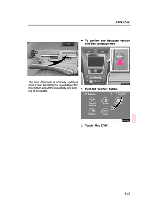 150
150 151
151 152
152 153
153 154
154 155
155
