Page 27 of 63

USB* Connection
24Authorised radio equipment
To guarantee optimum performance your vehicle should have an RCD series
SEAT radio or an RNS series SEAT navigator.
If your vehicle uses other brands we cannot guarantee their performance.
Compatible music formats
The following are the compatible music formats:•
mp3 (MPEG1 Layer3 32 to 320 kbps)
•
wma (8 to 192 kbps)
•
wav (sample frequency: 16 kHz with 16 bit coding, stereo)
•
ogg vorbis (to q10, 48 kHz, stereo)
DRM formats are not supported.Caution
Never store vital data in the memory stick or MP3 player SEAT will not accept
any responsibility for data or files that are corrupted or lost.
Note
If unauthorised memory sticks or MP 3 players are used, the music may not
play, or play poorly
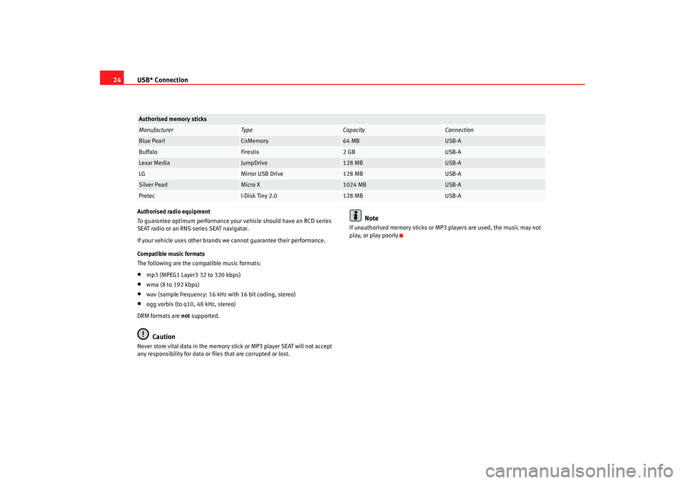
Authorised memory sticksManufacturer
Ty pe
Capacity
Connection
Blue Pearl
CnMemory
64 MB
USB-A
Buffalo
Firestix
2 GB
USB-A
Lexar Media
JumpDrive
128 MB
USB-A
LG
Mirror USB Drive
128 MB
USB-A
Silver Pearl
Micro X
1024 MB
USB-A
Pretec
I-Disk Tiny 2.0
128 MB
USB-A
MFD2 ingles Seite 24 Montag, 15. Mai 2006 9:19 09
Page 45 of 63

Navigation
42
– The MFD2 radio navigation system will now travel along the route virtually from start to finish if the route guidance function is
started. You can listen to announcements and look at displays.The navigation system will need some time for an exact definition of your
position if you have transported your vehicle using the train or a ferry. Your
position can be entered manually if the automatic definition is not
successful.
The manual position input can be used to calculate a route between any two
points regardless of where the vehicle is actually located.Manually excluding stretches of the journey
Stretches of the journey ahead and/or parts of the route list
can be blocked manually.
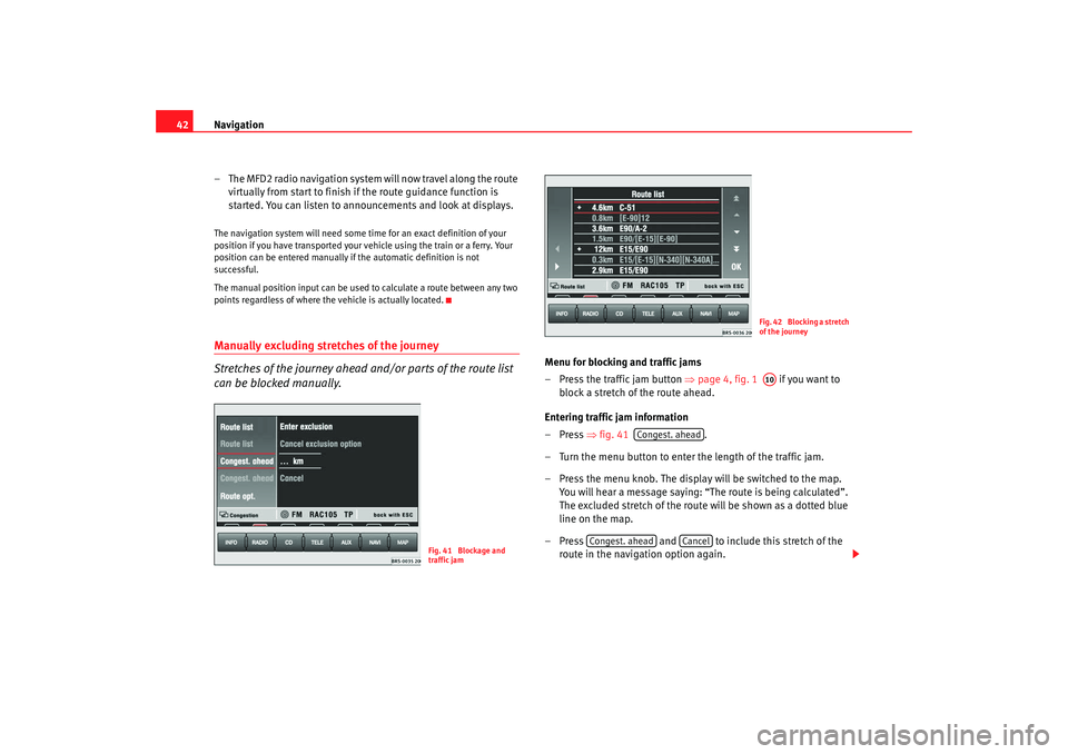
Menu for blocking and traffic jams
– Press the traffic jam button ⇒page 4, fig. 1 if you want to
block a stretch of the route ahead.
Entering traffic jam information
–Press ⇒fig. 41 .
– Turn the menu button to enter the length of the traffic jam.
– Press the menu knob. The display will be switched to the map. You will hear a message saying: “The route is being calculated”.
The excluded stretch of the route will be shown as a dotted blue
line on the map.
– Press and to include this stretch of the
route in the navigation option again.
Fig. 41 Blockage and
traffic jam
Fig. 42 Blocking a stretch
of the journeyA10
Congest. ahead
Congest. ahead
Cancel
MFD2 ingles Seite 42 Montag, 15. Mai 2006 9:19 09
Page 46 of 63

Navigation43
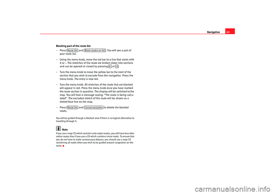
Blocking part of the route list
– Press and . You will see a part of
your route list.
– Using the menu knob, move the red bar to a line that starts with
+ or -. The stretches of the route are broken down into sections
and can be opened or closed by pressing or .
– Turn the menu knob to move the yellow bar to the start of the section that you wish to exclude from the navigation. Press the
menu knob. The entry is now red.
– Turn the menu knob. All stretches of the route that are blocked will appear in red. Press the menu knob once you have marked
the route section in question. The display will be switched to the
map. You will hear a message saying: “The route is being calcu-
lated”. The excluded stretch of the route will be shown as a
dotted blue line on the map.
– Press and to delete the blocked
roads.
You will be guided through a blocked area if there is no logical alternative to
travelling through it.
Note
If you use a map CD which contains only major routes, you will have less alter-
native routes than if you use a CD which contains minor roads. To ensure that
you do not have to make unnecessary detours, you should use a map CD
containing all roads when you wish to be guided around congestion on the
route.
Route list
Block routes on list
Route list
Cancel exclusion
MFD2 ingles Seite 43 Montag, 15. Mai 2006 9:19 09
Page 47 of 63
Navigation
44Map and symbol displaysInformation in the map and symbol displays
Information on the route will be shown in the map or symbol
displays if the route guidance function is active.
– Press the button ⇒page 4, fig. 1 . The screen will
switch between map and symbol displays.Map display
Autozoom active (
in red). The scale of the map will, for example, be
larger for motorway driving and more detailed when making a turn.
Journey time or arrival time.
Distance to destination or stopover.
Road name.
Vehicle position. The red arrow points in the direction of travel. The route
ahead is shown as a blue line.
Route options and “ TMC”.
− If the dynamic route guidance option is active, the horizontal arrow is
shown with a D, and blocked roads are shown as
.
− “TMC ”: The number of “ TMC” reports received is shown by the white
dots.
Fig. 43 Map display
Fig. 44 Symbol display
MAP
A12
AAABACADAEAF
MFD2 ingles Seite 44 Montag, 15. Mai 2006 9:19 09