141 Navigation
Route guidance
Important map symbols:�
Current vehicle location and direction
of travel y
If the map orientation
2D Heading Up
(�page 153) is chosen, the arrow will
always point upward.
�
The remaining route section is
highlighted in blue color.
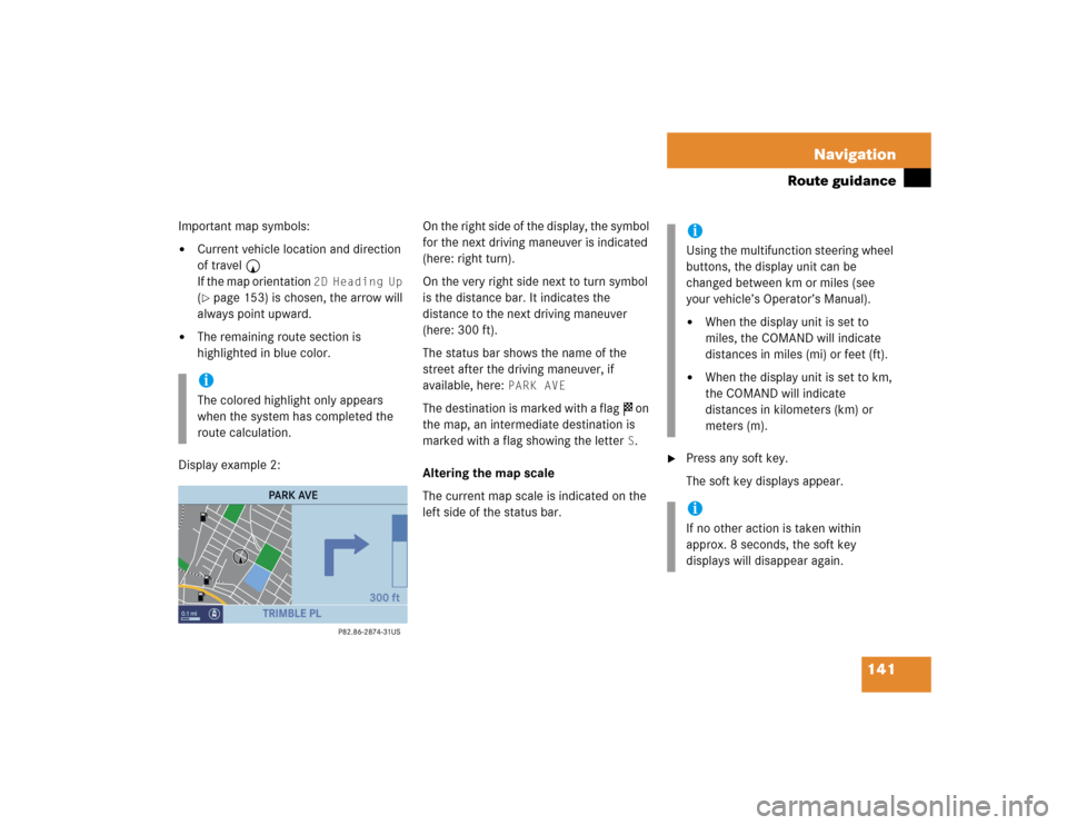
Display example 2:On the right side of the display, the symbol
for the next driving maneuver is indicated
(here: right turn).
On the very right side next to turn symbol
is the distance bar. It indicates the
distance to the next driving maneuver
(here: 300 ft).
The status bar shows the name of the
street after the driving maneuver, if
available, here:
PARK AVE
The destination is marked with a flag $ on
the map, an intermediate destination is
marked with a flag showing the letter
S.
Altering the map scale
The current map scale is indicated on the
left side of the status bar.
�
Press any soft key.
The soft key displays appear.
iThe colored highlight only appears
when the system has completed the
route calculation.
iUsing the multifunction steering wheel
buttons, the display unit can be
changed between km or miles (see
your vehicle’s Operator’s Manual). �
When the display unit is set to
miles, the COMAND will indicate
distances in miles (mi) or feet (ft).
�
When the display unit is set to km,
the COMAND will indicate
distances in kilometers (km) or
meters (m).
iIf no other action is taken within
approx. 8 seconds, the soft key
displays will disappear again.
145 Navigation
During route guidance
Available soft keys�
Route
soft key:
Brings you to the route display on the
map.
�
Mode
soft key:
Brings you to the route mode selection
menu (�page 120).
�
Setting
soft key:
Brings you to the audio settings for the
navigation announcements
(
�page 121).Displaying the route on the map
�
In the Info menu (
�page 144), press
the
Route
soft key.
The map will appear. The route ahead
is blue-colored.
The destination is marked with a flag $
on the map, a stopover destination is
marked with a flag showing the letter
S.
Displaying the route list
�
In the Info menu (
�page 144), press
the
Route
soft key.
The route appears on the map.
�
Press the
List
soft key.
The list of the remaining roads/route
sections appears.
The road currently travelled on is at the
top of the list.
�
Press G or g to scroll through the
list.
Use the
Page
V and
Page
v soft keys
to display the next or previous page.
iIf a stopover destination has been
entered:
The estimated time of arrival and the
remaining distance to the destination
are displayed.
When the stopover destination is
reached, the system calculates the
route to the main destination and
indicates estimated time of arrival and
remaining distance.
iDepending on the distance to the
destination, it may take some time
before the route display appears.
iDepending on the distance to the
destination, it may take a few moments
before the route list is completed.
The list will only be complete when the
route is completely calculated. This is
indicated by the word
Destination
in
front of the last list entry.