Page 164 of 226
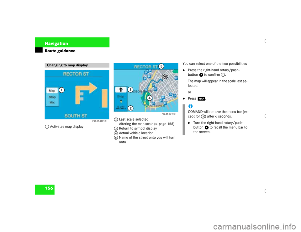
156 NavigationRoute guidance1Activates map display2Last scale selected
Altering the map scale (
�page 158)
3Return to symbol display
4Actual vehicle location
5Name of the street onto you will turn
ontoYou can select one of the two possibilities
�
Press the right-hand rotary/push-
button v to confirm 1.
The map will appear in the scale last se-
lected.
or
�
Press l.
Changing to map display
iCOMAND will remove the menu bar (ex-
cept for 3) after 6 seconds.�
Turn the right-hand rotary/push-
button v to recall the menu bar to
the screen.
Page 165 of 226
157 Navigation
Route guidance
If the function Mix is switched on, the sym-
bol display is activated automatically from
the map display before making a maneu-
ver. After you have made the maneuver,
the map will appear again.
Switching the mix function on�
Turn the right-hand rotary/push-
button v to highlight “Mix” in the sym-
bol display and press to confirm.
“Mix” appears in red.
Switching the mix function off
�
Turn the right-hand rotary/push-
button v to highlight “Mix” in the map
or symbol display and press to confirm.
“Mix” appears in black again.Map display before making a maneuver,
mix function is switched on
-As the maneuver, e.g. a U-turn, approa-
ches, COMAND will activate the symbol
display.
After you have made the U-turn, the map
will appear again.
Mix of map and symbol display
Page 167 of 226

159 Navigation
Route guidance
You can either select the map in north-up
orientation or position it with the driving di-
rection pointing up.North-up: Map is displayed facing north 1Selecting map orientation
North arrow ! or compass needle <
(black tipping pointing to the north)
2Symbol for current vehicle locationSelecting driving direction pointing up
Heading-up: Map is displayed facing driving
direction pointing up�
Turn the right-hand rotary/push-
button v to highlight 1 and press to
confirm.
Symbol 2 points in the driving direc-
tion, the compass needle will appear.To return to North-up
�
Turn the right-hand rotary/push-
button v to highlight 1 and press to
confirm.
The north arrow will appear again.
Selecting map orientation
Map orienta-
tion
Characteristics
North-up
North arrow always
points to the top
The symbol for the cur-
rent vehicle location is
turning on the map
Heading-up
The symbol for the cur-
rent vehicle location al-
ways points to the top
The compass needle is
turning, the black point
always points north
Page 170 of 226
162 NavigationRoute guidanceCanceling the calculation �
Press the right-hand rotary/push-
button v to confirm “Cancel”.Deleting way point
�
Turn the right-hand rotary/push-
button v to highlight “Stop” in the
symbol or map display and press to
confirm.
The “Way Point” menu will appear, “De-
lete stop-over...” is highlighted.
Menu bar is not visible in the map:�
Turn the right-hand rotary/push-
button v.
The menu bar will appear.
�
Press the right-hand rotary/push-
button v to confirm “Delete stop-
over...”.
The way point has been deleted.
If you do not want to delete the way point
�
Press *.iIt is also possible to delete a way point
in the menu (
�page 167).
Page 173 of 226
165 Navigation
Route guidance
Detour in route list�
Turn the right-hand rotary/push-
button v to highlight “Detour in Route
List” in the main detour menu and
press to confirm.
The message “The route list is being
calculated” will appear.
Then the route list will appear.
Route list1Street cannot be blocked off
2Symbol “+”: street contains several
sections which can be blocked off
3Blocked street will appear in redDisplaying an entry in full in a window
�
Press u.
�
Press u again to remove the window.
Page 174 of 226

166 NavigationRoute guidanceCalling detailed route list Detailed route list4Symbol “-” - sections of a road are dis-
played�
Press +.
The detailed route list will appear.Blocking off several streets/street sec-
tions
�
Turn the right-hand rotary/push-
button v to the right.
With each turn, you will block another
section.
The road name will appear in red.
Undoing street block
�
Turn the right-hand rotary/push-
button v to the left.
The street name will appear in black
again.
Switching back to the route list
�
Press ,.
The symbol “+” appears in front of the
street section.
The blocking function is still active.Canceling blocking function, do not recal-
culate the route
�
Press *.
The traffic jam menu will appear.
Ending the blocking function, re-calcula-
ting the route with the blocks selected
�
Press the right-hand rotary/push-
button v.
COMAND re-calculates the route in the
previously selected calculation mode.
A corresponding message will appear.
Then the symbol display will appear
again and COMAND will continue route
guidance.
Page 175 of 226
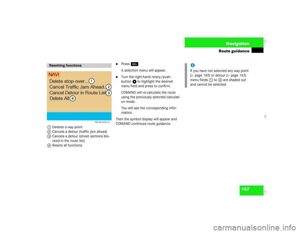
167 Navigation
Route guidance
1Deletes a way point
2Cancels a detour (traffic jam ahead)
3Cancels a detour (street sections blo-
cked in the route list)
4Resets all functions
�
Press r.
A selection menu will appear.
�
Turn the right-hand rotary/push-
button v to highlight the desired
menu field and press to confirm.
COMAND will re-calculate the route
using the previously selected calculati-
on mode.
You will see the corresponding infor-
mation.
Then the symbol display will appear and
COMAND continues route guidance.
Resetting functions
iIf you have not selected any way point
(�page 160) or detour (
�page 163)
menu fields 1 to 4 are shaded out
and cannot be selected.
Page 176 of 226
168 NavigationRoute guidanceIf you deviate from a recommended route,
the COMAND automatically calculates a
new route from the current vehicle locati-
on to the requested destination.If applicable, the message “NEW ROUTE”
will appear along with an arrow outline in-
dicating the driving direction.
After the new calculation has been suc-
cessfully completed, COMAND continues
route guidance.
The arrow indicating the driving direction
will appear as usual.If the symbol display is active, the map
showing the current vehicle location relati-
ve to the route will appear after 5 seconds.
COMAND automatically changes back to
the symbol display if a known road is used
again.Deviating from the calculated route
Driving on a non-digitized road