2022 KIA CARNIVAL navigation system
[x] Cancel search: navigation systemPage 97 of 316
5-5
A
Vehicle location may not be displayed correctly if:
The vehicle is driving on a Y-shaped or winding road with narrow angles.
The vehicle is driving closely to another road.
The vehicle is driving on a road where there are many tall buildings in the vicinity.
The vehicle is driving on a new road or a road under construction.
The vehicle is transported by a ferry or heavy-duty transport vehicle.
The vehicle is driving in a rugged mountain area or on a steep curve road.
The vehicle is entering a public road after making a turn through the turntable in an
underground parking lot or multi-story parking lot.
The vehicle stops and starts repeatedly or moves slowly in front of an intersection.
The system reboots after the vehicle battery has been recharged or replaced.
The vehicle is driving on a slippery road due to heavy snow, etc.
The tires have been replaced recently or spare tires (or studless tires) are used.
Improper-sized tires are used or the pressure of each tire is different.
The replaced tire is worn out or the studless tires have been used for over two seasons.
A roof carrier is installed on the vehicle.
On a highway. continued driving causes the system to perform map matching or apply
the updated GPS data.
A
Navigation service may not be provided correctly under the following conditions:
When the vehicle drives on a straight road continuously, the system may guide you to
drive straight. It is not a malfunction.
Guidance may not be followed immediately after the vehicle makes a turn at an
intersection or drives through an intersection.
The system may guide you to make a U-turn in a prohibited area.
The system may guide you to a traffic-blocked road (e.g. no-entry road or road under
construction).
The system may guide you to a road away from the destination when there is no road
to the destination or there are only narrow roads on the way.
Guidance may not be proper when the vehicle is off the route.
Guidance may not match the actual distance on an overpass or underpass due to the
difference of the start point.
When you are driving at high speeds, route recalculations may take longer.
A
Because the navigation system is used for information purposes only, Kia does not
assume responsibility of the accuracy of the information.
A
When the traffic information is not received, the status icon appears at the top of the map
screen.
HD Radio: The system is using the HD radio data. If no traffic information is available,
the status icon (
) will be displayed instead.
Page 118 of 316

5-26
Setting a registered favorite place as a destination
You can set any in the address book of the navigation system as a destination.
1 On the Navigation Menu screen, press Address Book.
2 Select the desired group.
3 Select the place to set as a destination.
4 Check the location of the destination and then press Set as Destination.
5 Select the desired route from the searched ones and press Start
Guidance.
Registering a frequently visited place as a destination
You can set your home, office, or other frequently visited places as a destination directly from
your favorites list once you add them.
At the bottom of the Navigation Menu screen, press a desired shortcut
button.
Route guidance immediately starts for the destination.
A When guidance to a destination is in progress, press Change Destination.
A
Available icons and their arrangement may differ depending on the vehicle model and
specifications.
Page 122 of 316
5-30
END USER LICENSE AGREEMENT
PLEASE READ THIS END USER LICENSE AGREEMENT ("EULA") CAREFULLY BEFORE USING THE
NAVIGATION SYSTEM.
This is a license agreement between you and Hyundai MnSoft, INC. including its affiliates
("COMPANY") regarding a copy of the COMPANY navigable map database together with
associated software, media and explanatory printed documentation published by COMPANY
(jointly the "Product"). The Product is provided for your personal, internal use only and not for
resale. It is protected by copyright and is subject to the following terms which are agreed to
by you, on the one hand, and COMPANY and its licensors (and their licensors and suppliers)
(collectively, "Licensors") on the other hand.
By using the Product, you accept and agree to all terms and conditions in this End User
License Agreement ("EULA"). IF YOU DO NOT AGREE TO THE TERMS OF THIS EULA, YOU
MUST PROMPTLY EXIT THE PRODUCT OPERATION PROGRAM AND DO NOT USE OR ACCESS
TO THE PRODUCT. YOU AGREE THAT YOUR RIGHTS UNDER THIS EULA MAY BE TERMINATED
AUTOMATICALLY WITHOUT NOTICE IF YOU FAIL TO COMPLY WITH ANY TERM(S) OF THIS
EULA.
Terms and Conditions
Personal Use Only. You agree to use this Product together with COMPANY's authorized
application for the solely personal, non-commercial purposes for which you were licensed,
and not for service bureau, time-sharing or other similar purposes. Accordingly, but subject to
the restrictions set forth in the following paragraphs, you agree not to otherwise reproduce,
copy, modify, decompile, disassemble, create any derivative works of, or reverse engineer any
portion of this Data, and may not transfer or distribute it in any form, for any purpose, except
to the extent permitted by mandatory laws. You may not assign this EULA or any of the rights
or licenses granted under this EULA, except when installed in the system for which it was
created.
Restrictions. Except where you have been specifically licensed to do so by COMPANY, and
without limiting the preceding paragraph, you may not use the Product (i) with any products,
systems, or applications installed or otherwise connected to or in communication with
vehicles, capable of vehicle navigation, positioning, dispatch, real time route guidance, fleet
management or similar applications; or (ii) with or in communication with any positioning
devices or any mobile or wireless-connected electronic or computer devices, including
without limitation cellular phones, palmtop and handheld computers, pagers, and personal
digital assistants or PDAs.
Page 185 of 316
8-11
Configuring the UVO settings
You can subscribe to the UVO service or see the modem information.
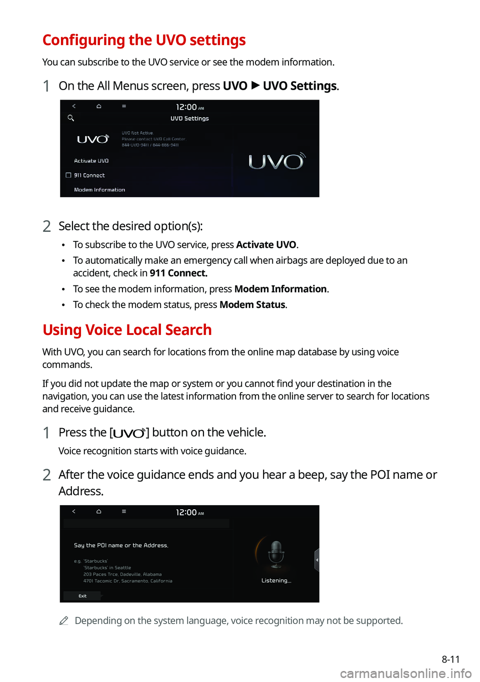
1 On the All Menus screen, press UVO >
UVO Settings.
2 Select the desired option(s):
• To subscribe to the UVO service, press Activate UVO.
•To automatically make an emergency call when airbags are deployed due to an
accident, check in 911 Connect.
•To see the modem information, press Modem Information.
•To check the modem status, press Modem Status.
Using Voice Local Search
With UVO, you can search for locations from the online map database by using voice
commands.
If you did not update the map or system or you cannot find your destination in the
navigation, you can use the latest information from the online server to search for locations
and receive guidance.
1 Press the [] button on the vehicle.
Voice recognition starts with voice guidance.
2 After the voice guidance ends and you hear a beep, say the POI name or
Address.
A
Depending on the system language, voice recognition may not be supported.
Page 186 of 316
8-12
Route guidance service (if equipped)
Use a more convenient, accurate route guidance service through the UVO route guidance
service.
Finding the route to the destination by manual entry
You can enjoy fast and accurate route guidance based on real-time traffic data and
forecasting traffic information collected by the UVO Center.
Using the UVO quick route guidance
You can use the quick navigation service based on real-time traffic information analyzed by
the UVO Center.
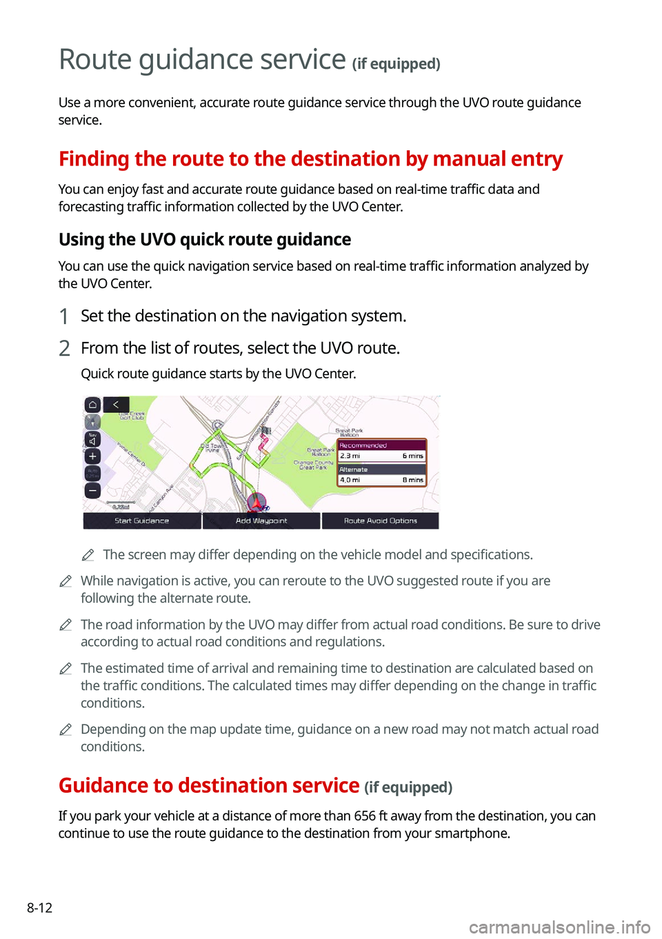
1 Set the destination on the navigation system.
2 From the list of routes, select the UVO route.
Quick route guidance starts by the UVO Center.
AThe screen may differ depending on the vehicle model and specifications.
A
While navigation is active, you can reroute to the UVO suggested route if you are
following the alternate route.
A
The road information by the UVO may differ from actual road conditions. Be sure to drive
according to actual road conditions and regulations.
A
The estimated time of arrival and remaining time to destination are calculated based on
the traffic conditions. The calculated times may differ depending on the change in traffic
conditions.
A
Depending on the map update time, guidance on a new road may not match actual road
conditions.
Guidance to destination service (if equipped)
If you park your vehicle at a distance of more than 656 ft away from the destination, you can
continue to use the route guidance to the destination from your smartphone.
Page 187 of 316

Settings
Configuring system settings
Configuring the vehicle settings (Type1/Type2)
Configuring the device connections settings(Type1/Type2) Configuring the advanced system settings (Type1) Configuring the button settings (Type1/Type2)Configuring the sound settings (Type1/Type2)
Configuring the voice recognition settings (Type1/Type2) Configuring the navigation settings (Type1/Type2)Configuring the UVO settings (Type1/Type2)
Configuring the user profile settings (Type1/Type2)
Configuring the general system settings (Type1/Type2) Configuring the display settings (Type1/Type2)Configuring the media settings (Type1)
How to Update the Map and Software for your
Infotainment System
09
Page 191 of 316
9-5
Driving Convenience (if equipped)
You can set to use the driving convenience options such as lane keeping assistance and
speed limit warning.
A
The driving convenience system operates based on the information from the navigation
system, so you must use the system only when the navigation system operates normally.
•Highway Driving Assist: According to the speed of a leading vehicle on expressways, it
assists to keep the safety distance at a set speed.
A
The highway driving assist system operates only on a highway. When the vehicle exits
from the highway, the system is turned off automatically.
•Highway Auto Speed Zone Slowdown: The driving speed automatically decreases in the
highway speed zone.
A
The highway auto speed zone slowdown system operates only on a highway. When
the vehicle exits from the highway, the system is turned off automatically.
A
It operates considering the speed cameras located on the selected route.
•Highway Auto Curve Slowdown: The driving speed automatically decreases in the
highway curve zone.
A
It operates based on the curve zones on the route. When the destination is not set, it
operates based on the curve zones on the expected path.
Warning Timing (if equipped)
You can select the warning timing by the driving assist system.
Warning Volume (if equipped)
You can adjust the warning volume by the driving assist system.
Driver Attention Warning (if equipped)
If necessary, set to output alerts to prevent accidents by analyzing the driving patterns.
•Leading Vehicle Departure Alert: When the leading vehicle departs, the notification is
provided.
ÝWarning
Be sure to always check the road conditions ahead or surroundings before departure. An
accident caused by distracted driving can be prevented.
•Safety Notice Call: Used to set to make a call for checking your safety to UVO Center
when suspected that vehicle movement is dangerous.
•Inattentive Driving Warning: Set the system to remind when it detects a distracted
driving pattern and suggest to take rest if needed.
Page 224 of 316

9-38
Configuring the advanced system settings
(Type1)
(if equipped)
You can configure the settings for notification and button actions.
1 On the All Menus screen, press Setup >
Advanced.
The advanced settings screen appears.
2 Configure the settings required:
Return to Map: Set Time
You can set the system to automatically display the map screen after a specified period of
time when switched to the Radio/Media mode screen while using the navigation.
A
This function works while driving once a destination has been set.
A
This feature is not available on the phone projection screen.
TUNE Knob Function
You can change the [TUNE/FILE] knob's function on the map.