Page 186 of 268
6. Navigation (if so equipped)
[Save Route]The current route (a destination and waypoints) can be saved. A maximum
of 10 routes can be saved. The saved routes can easily be recalled for
future use. Saved route includes only the location information, not the
route itself. Route may vary depending on the traffic information or other
conditions.
[Map Scroll] Displays the current map screen which can be scrolled to confirm the
location of the destination, waypoints, route, etc.
[Simulation] Simulates the route guidance. This function provides a detailed image of
the route with voice guidance.
The following operations are available:
[
]: Pauses the simulation.
[]: Resumes the simulation.
[]: Ends the simulation.
[+]/[-]: Increases/decreases the play speed.
INFO:
When a destination is set, [Cancel Route] and [Turn List] will be displayed on the MENU screen.
“How to view and operate MENU screen” (page 2-18)
6-32
Page 189 of 268
![INFINITI Q50 2021 Infiniti Intouch [Never Use]Calculates route avoiding the use of seasonal restricted
roads.
[Use Traffic Informa-
tion] [Auto]
Calculates the route automatically taking traffic information
into consideration.
[Accept]](/manual-img/42/35007/w960_35007-188.png "INFINITI Q50 2021 Infiniti Intouch [Never Use]Calculates route avoiding the use of seasonal restricted
roads.
[Use Traffic Informa-
tion] [Auto]
Calculates the route automatically taking traffic information
into consideration.
[Accept]")
[Never Use]Calculates route avoiding the use of seasonal restricted
roads.
[Use Traffic Informa-
tion] [Auto]
Calculates the route automatically taking traffic information
into consideration.
[Accept] If a traffic jam or incident occurs, a confirmation screen will
appear before calculation.
[OFF] Calculates the route without taking traffic information into
consideration.
[Use Avoid Area Settings] When enabled, the system avoids the previously defined
avoid areas.
[Use Ferries] Includes the use of ferries.
[Use Car-Carrying Trains] Includes the use of car-carrying trains.
[Use Unpaved Roads] Includes the use of unpaved roads.
[Use HOV Lanes] Includes the use of HOV lanes.
[Use Learned Routes] Uses the roads that are most frequently traveled with the help
of self-learning technology.
[Customize More
Routes] [3types]
Calculates 3 types of route when confirming other routes.
[1type] Calculates an alternative route when confirming other routes.
[Estimated Time] [Destination] Displays the estimated time of arrival or remaining time to the
destination during route guidance.
[Waypoint] Displays the estimated time of arrival or remaining time to the
waypoint during the route guidance.
[Time Shown on Map] [ETA] Displays the estimated time of arrival.
[Remaining] Displays the remaining time to arrive.
6. Navigation (if so equipped)
6-35
Page 190 of 268
6. Navigation (if so equipped)
INFO:
. If the vehicle greatly deviates from the suggested route, the system calculates a new route.
. Traffic jam information displayed on the map screen is not statistical traffic information.
. If [Ignore Restrictions] is selected for [Time Restricted Roads] setting, the system calculates a route without any consideration of the
regulations concerning the time or day of the week. Therefore, the suggested route may include a road subject to traffic regulations
concerning the time or day of the week. When driving along the route, always follow all traffic regulations regardless of whether [Time
Restricted Roads] is set to be considered or not.
. Even when [Use Traffic Information] is turned on, if traffic information has not been provided for the area, a detour may not always be
indicated in a location where a traffic jam occurs.
. The system calculates to reduce the time required for the entire route from the start to the destination. If there are no appropriate routes,
the system may lead to a route where a traffic jam occurs instead of leading to a detour.
. The system may not lead to a detour if the traffic closure or a traffic jam occurs far from the present location.
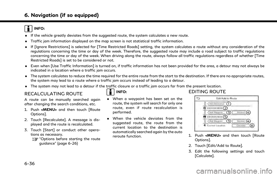
RECALCULATING ROUTE
A route can be manually searched again
after changing the search conditions, etc.
1. Push
Page 192 of 268
![INFINITI Q50 2021 Infiniti Intouch 6. Navigation (if so equipped)
3. Touch a destination or waypoint that isalready set.
4. Touch to edit the following settings: Available setting items
.[Delete]:A selected destination or waypoint
that](/manual-img/42/35007/w960_35007-191.png "INFINITI Q50 2021 Infiniti Intouch 6. Navigation (if so equipped)
3. Touch a destination or waypoint that isalready set.
4. Touch to edit the following settings: Available setting items
.[Delete]:A selected destination or waypoint
that")
6. Navigation (if so equipped)
3. Touch a destination or waypoint that isalready set.
4. Touch to edit the following settings: Available setting items
.[Delete]:A selected destination or waypoint
that has already been set can be
deleted.
.[Change Order]:The order of a destination and way-
points that are already set can be
changed.
.[Move Destination]:
The location of the destination or
waypoint can be adjusted by moving
the cross pointer across the map on
the touch screen display.
5. Touch [Calculate] to apply the change.
INFO:
If the destination is deleted, the route
guidance will be canceled.
Changing route calculation condi-
tions
Each section of the route between way-
points can have different route calculation
conditions.
1. Push
Page 194 of 268
![INFINITI Q50 2021 Infiniti Intouch 6. Navigation (if so equipped)
GUIDANCE SETTINGS
Various settings are available to customize the guidance information provided by the system.
1. Push<MENU> and touch [Settings].
2. Touch [Navigation]](/manual-img/42/35007/w960_35007-193.png "INFINITI Q50 2021 Infiniti Intouch 6. Navigation (if so equipped)
GUIDANCE SETTINGS
Various settings are available to customize the guidance information provided by the system.
1. Push<MENU> and touch [Settings].
2. Touch [Navigation]")
6. Navigation (if so equipped)
GUIDANCE SETTINGS
Various settings are available to customize the guidance information provided by the system.
1. Push
Page 198 of 268

6. Navigation (if so equipped)
Remaining distance and estimated re-
maining time/time of arrival:
Remaining distance and estimated re-
maining time to the destination/time
of arrival calculated with consideration
of traffic information on route is dis-
played.
Whether to display the remaining time
to the destination or estimated arrival
time at the destination can be selected.
“Route Preference” (page 6-34)
Road conditions:
Free Flow: Green
Slow traffic: Yellow
Heavy traffic: Red
Road closed and section affected by
serious traffic event: Orange and white
stripes
Queuing traffic: Orange (Premium
Traffic information only)
Traffic information icon:
If a route is not already set, all of the
traffic information icons on the map
screen are displayed in gray. When a
route is already set, the icons on the
route are displayed in color, and the
icons outside the route are displayed in
gray.
: Traffic jam
: Slow traffic
: Traffic flowing freely
: Road closed
: Accident
: Road work
: Narrow lanes
: All other events
Traffic indicator:
SiriusXM TrafficTM
Displayed when there is available Sir-
iusXM TrafficTMInformation received.
A SiriusXM TrafficTMsubscription is
necessary to view traffic information.
PREMIUM TRAFFIC
Displayed when there is available Pre-
mium Traffic Information received.
INFO:
Traffic icons are displayed in the scale level
of 1/64 miles (15 m) - 7.5 miles (12.5 km)
range. Some traffic icons are displayed only
on the map at higher detail levels.
TRAFFIC INFORMATION
SETTING
Settings for traffic information related func-
tions can be changed.
1. Push
Page 208 of 268
![INFINITI Q50 2021 Infiniti Intouch 6. Navigation (if so equipped)
NAVIGATION SETTINGS
The navigation system can be customized according to the user’s preference.
1. Push<MENU> and touch [Settings].
2. Touch [Navigation].
3. Touch the](/manual-img/42/35007/w960_35007-207.png "INFINITI Q50 2021 Infiniti Intouch 6. Navigation (if so equipped)
NAVIGATION SETTINGS
The navigation system can be customized according to the user’s preference.
1. Push<MENU> and touch [Settings].
2. Touch [Navigation].
3. Touch the")
6. Navigation (if so equipped)
NAVIGATION SETTINGS
The navigation system can be customized according to the user’s preference.
1. Push
Page 210 of 268

6. Navigation (if so equipped)
GENERAL INFORMATION FOR
NAVIGATION SYSTEM
CURRENT VEHICLE LOCATION
Display of current vehicle location
This navigation system combines the data
obtained from the vehicle (by gyro sensor)
and from GPS (Global Positioning System)
satellites to calculate the current location of
the vehicle. This position is then displayed
throughout route guidance to a destination.
What is GPS (Global Positioning
System)?
GPS is a position detecting system that uses
satellites deployed by the U.S. government.
This navigation system receives radio signals
from three or more different satellites that
orbit 13,049 miles (21,000 km) above the
earth in space, and detect the position of the
vehicle by utilizing the principle of triangula-
tion.
Positioning adjustment:
When the system judges that the vehicle
position is not accurate based on vehicle
speed and gyro sensor data calculations, the
system will automatically adjust the position of the vehicle icon using GPS signals.
Receiving signals from GPS satellites:
The reception of GPS signals can be weak,
depending on the environment. Vehicles in
the following areas/environments may not
receive GPS signals.
* Inside tunnels or parking garages
*In areas with numerous tall buildings
*Under multi-layered highways
6-56
![INFINITI Q50 2021 Infiniti Intouch 6. Navigation (if so equipped)
[Save Route]The current route (a destination and waypoints) can be saved. A maximum
of 10 routes can be saved. The saved routes can easily be recalled for
future use. Sa](/manual-img/42/35007/w960_35007-185.png "INFINITI Q50 2021 Infiniti Intouch 6. Navigation (if so equipped)
[Save Route]The current route (a destination and waypoints) can be saved. A maximum
of 10 routes can be saved. The saved routes can easily be recalled for
future use. Sa")