Page 78 of 124
4“Addresses” should be underlined. If not,
touch “Addresses” and then type the
address you want.
a. Selecting this icon will display the current vehicle location.
b. Select this button to set the radius filter. Once the filter is set, the search will only
be performed for items within that
radius. This may need to be changed if
your destination is beyond the search
radius.
NOTE: You can toggle between
“Address” and “Point Of Interest” search
by selecting the one you want.
5 When the address appears on the screen select it.
6 Select “Go”.
MAPS
76
Page 79 of 124
7Select “Let’s Go”. If selected you will see
fuel stations, rest stops, hotels, etc on the
right side of the screen.
Finding a Destination By POI
To search by Points Of Interest (POI):
1 Push the “Map” button to display the map
screen.
MAPS
77
Page 80 of 124
2Then touch “Menu”.
3 Next, select “Search”.
4 Select “Points of Interest”.
NOTE: You can toggle between
“Address” and “Point Of Interest” search
by selecting the one you want.
5 Categories are listed alphabetically. Use
the scroll bar on the right, if needed, to
display more categories, then make your
selection. Select the desired item from the
list, then touch “GO”.
6 Finally select “Let’s Go” to start navigation
to the point of interst.
MAPS
78
Page 89 of 124
Traffic Information
Road sections affected by traffic conditions are displayed in a different color on the map,
and a small icon representing the type of traffic condition is displayed above the road.
To receive the data service information in the vehicle, a subscription to the SiriusXM
®
Traffic Services is required following a free trial.
Nearest Gas Station
When driving on the highway during route guidance, information on gas stations,
restaurants, or rest areas will be displayed on the right.
Select the desired item from the list, and then select “GO” to navigate to the closest
selected place.
Arrival Time/Distance
Displays the distance to the destination and/or the estimated arrival time at the
destination.
This is customizable by selecting “Settings” from the home screen, then “Navigation” and
finally “Arrival Distance/Time”.
Canceling Guidance
To cancel guidance, select “End”.
MAPS
87
Page 91 of 124

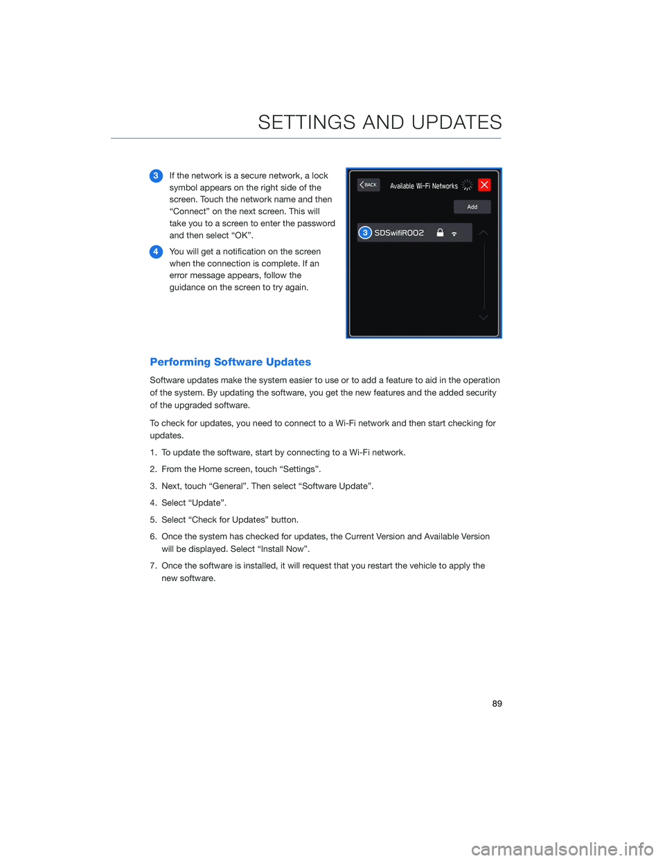
3If the network is a secure network, a lock
symbol appears on the right side of the
screen. Touch the network name and then
“Connect” on the next screen. This will
take you to a screen to enter the password
and then select “OK”.
4 You will get a notification on the screen
when the connection is complete. If an
error message appears, follow the
guidance on the screen to try again.
Performing Software Updates
Software updates make the system easier to use or to add a feature to aid in the operation
of the system. By updating the software, you get the new features and the added security
of the upgraded software.
To check for updates, you need to connect to a Wi-Fi network and then start checking for
updates.
1. To update the software, start by connecting to a Wi-Fi network.
2. From the Home screen, touch “Settings”.
3. Next, touch “General”. Then select “Software Update”.
4. Select “Update”.
5. Select “Check for Updates” button.
6. Once the system has checked for updates, the Current Version and Available Version
will be displayed. Select “Install Now”.
7. Once the software is installed, it will request that you restart the vehicle to apply the new software.
SETTINGS AND UPDATES
89
Page 94 of 124

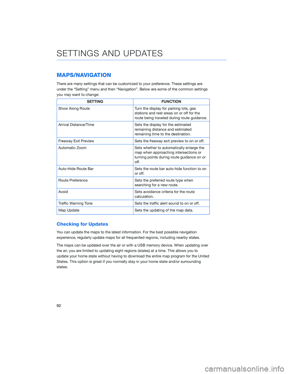
MAPS/NAVIGATION
There are many settings that can be customized to your preference. These settings are
under the “Setting” menu and then “Navigation”. Below are some of the common settings
you may want to change:
SETTINGFUNCTION
Show Along Route Turn the display for parking lots, gas
stations and rest areas on or off for the
route being traveled during route guidance.
Arrival Distance/Time Sets the display for the estimated
remaining distance and estimated
remaining time to the destination.
Freeway Exit Preview Sets the freeway exit preview to on or off.
Automatic Zoom Sets whether to automatically enlarge the
map when approaching intersections or
turning points during route guidance on or
off.
Auto-Hide Route Bar Sets the route bar auto-hide function to on
or off.
Route Preference Sets the preferred route type when
searching for a new route.
Avoid Sets avoidance criteria for the route
calculation.
Traffic Warning Tone Sets the traffic alert sound to on or off.
Map Update Sets the updating of the map data.
Checking for Updates
You can update the maps to the latest information. For the best possible navigation
experience, regularly update maps for all frequented regions, including nearby states.
The maps can be updated over the air or with a USB memory device. When updating over
the air, you are limited to updating eight regions (states) at a time. This allows you to
update your home state without having to download the entire map program for the United
States. This option is great if you normally stay in your home state and/or surrounding
states.
SETTINGS AND UPDATES
92
Page 101 of 124
3The screen to the right will be displayed
when pairing mode is in progress. The
device name will most likely be Subaru,
but be sure to make note of what name it
is so you can find it on your phone.
4 On your Android device, go to “Settings” (it can
be found under apps).
5 Next select “Connected Devices” or
“Connections”.
6 Now select “Bluetooth”. This will show a screen
to “Pair New Device” or it will be showing the
nearby devices to add. Select “Subaru”, if shown
on the list, or “Pair New Device”.
APPENDIX: HOW TO
99
Page 103 of 124
Pairing an iOS/Apple Device
1To pair an Apple device, start by touching
the “Phone” button on the Home screen.
2 If there is no phone connected, it will ask
you, “Do you want to add a device?”.
Select “Yes”. If a device has already been
paired, select “Add Device”.
3 When this screen is displayed, it is in
pairing mode. Note the “Device Name”; it
will most likely be “Subaru”.
APPENDIX: HOW TO
101