Page 110 of 263
uuMap MenuuDirections
108
Navigation
HHOMEuNaviu (Map menu) (on map)uDirectionsuExit Info
Display a list of the freeway exits for the route. You can view freeway exit
information (whether the exit is near fuel stations, restaurants, ATMs, etc.) and add
new destinations or waypoints to the calculated route.
1.Select an exit from the list.
2.Select a list item.
uSelect or to display
information for different exits.
uThe location is displayed on the
Calculate Route screen.
2Calculating the Route P. 98
■Freeway Exit Information1Freeway Exit Information
“Display Freeway Exit Information”
You can scroll the map and select a (freeway exit
information) icon on the map screen to display the
freeway exit information. The icon is only
displayed if there is exit information available.
Icons are displayed only at 1/4, 1/2, or 1 mile (400,
800, or 1600 m) scale.
2Map Scale and Functions P. 58
The system provides freeway exit information only in
the U.S.
Page 111 of 263
109
uuMap MenuuTraffic ReroutingTM
Continued
Navigation
Traffic ReroutingTM
When driving to your destination, the system automatically searches for a faster
route based on traffic flow information and traffic incidents.
2Map Screen Legend P. 10
1Traffic ReroutingTM
Traffic information is only available in certain areas.
Automatic traffic rerouting may not provide a detour
route depending on circumstances.
The route is recalculated only when Traffic
Rerouting is set to On.
2Traffic Rerouting P. 42
Page 112 of 263

uuMap MenuuTraffic ReroutingTM
110
Navigation
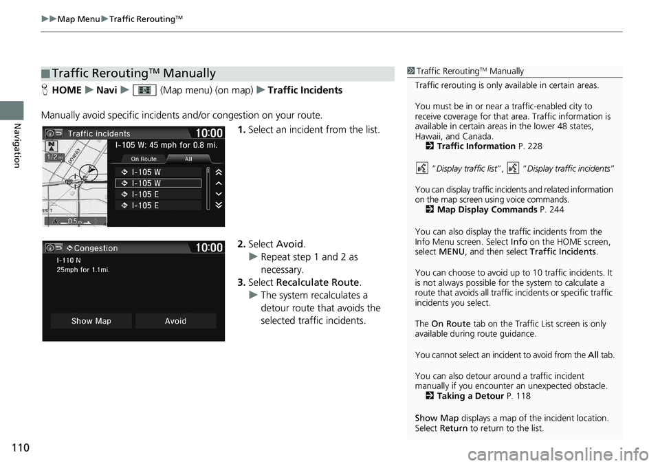
HHOMEuNaviu (Map menu) (on map)uTraffic Incidents
Manually avoid specific incidents and/or congestion on your route.
1.Select an incident from the list.
2.Select Avoid.
uRepeat step 1 and 2 as
necessary.
3.Select Recalculate Route.
uThe system recalculates a
detour route that avoids the
selected traffic incidents.
■Traffic ReroutingTM Manually1Traffic ReroutingTM Manually
Traffic rerouting is only available in certain areas.
You must be in or near a traffic-enabled city to
receive coverage for that area. Traffic information is
available in certain areas in the lower 48 states,
Hawaii, and Canada.
2Traffic Information P. 228
“Display traffic list”, “Display traffic incidents”
You can display traffic incidents and related information
on the map screen using voice commands.
2Map Display Commands P. 244
You can also display the traffic incidents from the
Info Menu screen. Select Info on the HOME screen,
select MENU, and then select Traffic Incidents.
You can choose to avoid up to 10 traffic incidents. It
is not always possible for the system to calculate a
route that avoids all traffic incidents or specific traffic
incidents you select.
The On Route tab on the Traffic List screen is only
available during route guidance.
You cannot select an incident to avoid from the All tab.
You can also detour around a traffic incident
manually if you encounter an unexpected obstacle.
2Taking a Detour P. 118
Show Map displays a map of the incident location.
Select Return to return to the list.
Page 120 of 263
118
uuChanging Your RouteuCanceling the Route
Navigation
Canceling the Route
HHOMEuNaviuMENU (when en route)uCancel Route
Cancel the route guidance and remove the destination and all waypoints from the
Destination List. The system then returns to the map screen.
Taking a Detour
HHOMEuNaviuMENU (when en route)uDetour
Calculate a detour route manually. The system attempts to calculate a new route by
avoiding the next 5 miles (8 km) (while on a freeway) or 1 mile (1600 m) (while on a
surface street).
1Canceling the Route
You can also cancel your route from the Map Menu.
2Map Menu P. 105
1Taking a Detour
The detour option is convenient if you encounter an
unexpected obstacle such as a road closure or
extremely heavy traffic congestion.
Page 121 of 263
119
uuChanging Your RouteuAvoiding Streets
Navigation
Avoiding Streets
HHOMEuNaviuMENU (when en route)uAvoid Streets
Select a street or streets along your route to avoid.
1.Select the street you want to
avoid.
uRepeat the procedure to avoid
other streets.
uStreets to be avoided are
indicated with a trash lid open
icon.
2.Select Recalculate Route.
uThe system calculates a new
route.1Avoiding Streets
Avoiding certain streets is convenient if you know of
road construction, road closures, or excessive traffic
along the route.
You cannot choose specific streets you want to use,
only those to avoid. However, you can select
intersections or waypoints (places/landmarks) that
the system will use in your route.
2Adding Waypoints P. 112
You can store up to 10 streets to avoid. You cannot
avoid your current street or the streets of your
waypoint(s) or destination (system beeps if selected).
Page 122 of 263
120
Navigation
Changing Your Destination
There are several methods you can use to change the route destination.
Find Nearest Place
HHOMEuNaviu (Map menu) (on map)uSearch Nearby
Search for the nearest place/landmark on the map screen and set it as your
destination.
1.Select a category type.
2.Select a subcategory.
3.Select a place.
4.Select Set as Destination.
5.Select Clear Current Route or
select a location to add to the
destination list.
uThe system calculates the route.
2Calculating the Route P. 98
1Find Nearest Place
“Find Nearest…” (on Voice Portal screen)
The Find Nearest voice command is the fastest
method of specifying a place/landmark as your
destination. Many kinds of places can be found.
2Find Place Commands P. 245
Page 136 of 263

134
uuPlaying FM/AM RadiouAudio Screen Control
Audio
Audio Screen Control
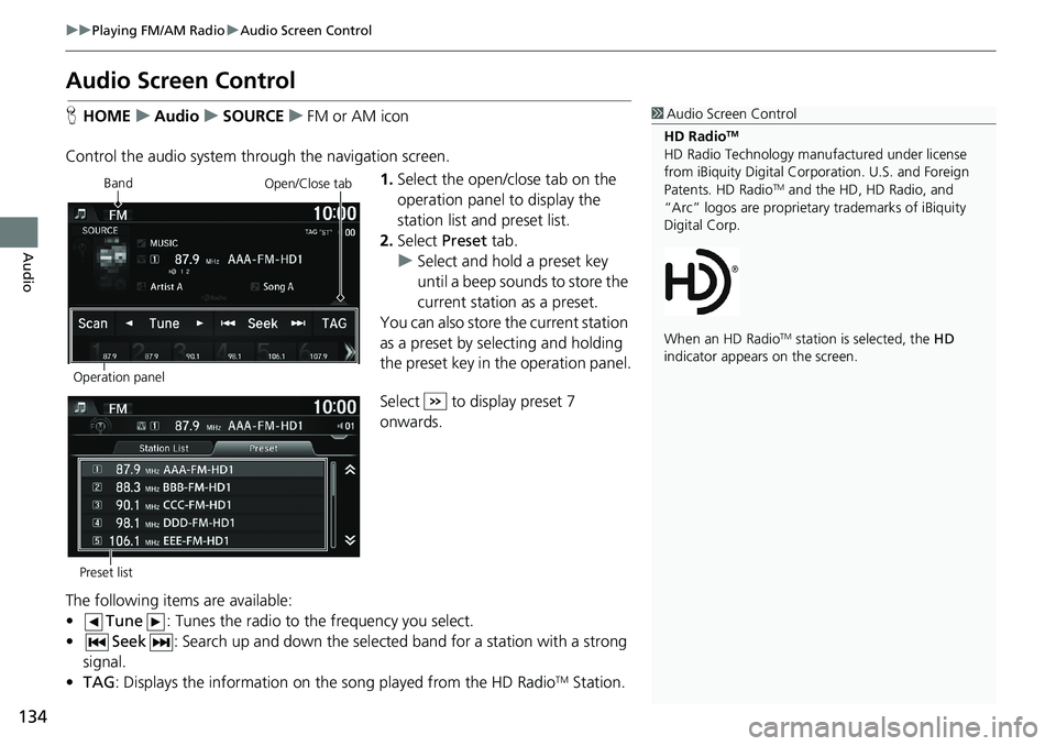
HHOMEuAudiouSOURCEuFM or AM icon
Control the audio system through the navigation screen.
1.Select the open/close tab on the
operation panel to display the
station list and preset list.
2.Select Preset tab.
uSelect and hold a preset key
until a beep sounds to store the
current station as a preset.
You can also store the current station
as a preset by selecting and holding
the preset key in the operation panel.
Select to display preset 7
onwards.
The following items are available:
•Tune: Tunes the radio to the frequency you select.
•Seek: Search up and down the selected band for a station with a strong
signal.
•TAG: Displays the information on the song played from the HD Radio
TM Station.
1Audio Screen Control
HD Radio
TM
HD Radio Technology manufactured under license
from iBiquity Digital Corporation. U.S. and Foreign
Patents. HD Radio
TM and the HD, HD Radio, and
“Arc” logos are proprietary trademarks of iBiquity
Digital Corp.
When an HD Radio
TM station is selected, the HD
indicator appears on the screen.
Band
Operation panelOpen/Close tab
Preset list
Page 140 of 263
138
uuPlaying SiriusXM® Radio*uAudio Screen Control
Audio
Audio Screen Control
HHOMEuAudiouSOURCEuSiriusXM® icon
Control the audio system through the navigation screen.
1.Select the open/close tab on the
operation panel to display the
channel list and preset list.
2.Select Preset tab.
uSelect and hold a preset until a
beep sounds to store the
current channel as a preset.
You can also store the current
channel as a preset by selecting and
holding the preset key in the
operation panel.
Select to display preset 7
onwards.
The following items are available:
•Category: Display and select an SiriusXM® Radio category.
•Channel: Select the previous or next channel.
Operation panelBand
Open/Close tab
Preset list