2017 NISSAN LEAF navigation
[x] Cancel search: navigationPage 215 of 268
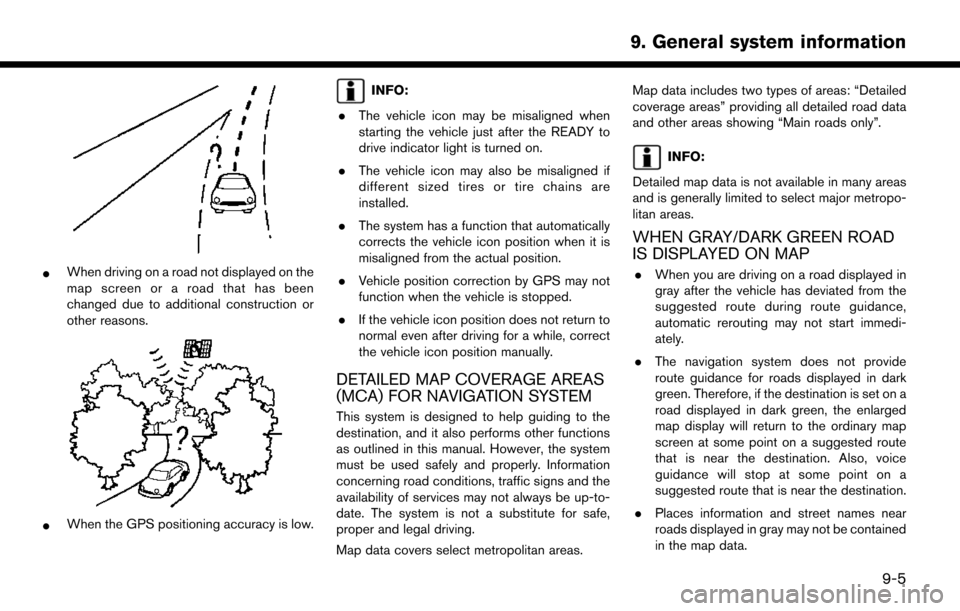
*When driving on a road not displayed on the
map screen or a road that has been
changed due to additional construction or
other reasons.
*When the GPS positioning accuracy is low.
INFO:
. The vehicle icon may be misaligned when
starting the vehicle just after the READY to
drive indicator light is turned on.
. The vehicle icon may also be misaligned if
different sized tires or tire chains are
installed.
. The system has a function that automatically
corrects the vehicle icon position when it is
misaligned from the actual position.
. Vehicle position correction by GPS may not
function when the vehicle is stopped.
. If the vehicle icon position does not return to
normal even after driving for a while, correct
the vehicle icon position manually.
DETAILED MAP COVERAGE AREAS
(MCA) FOR NAVIGATION SYSTEM
This system is designed to help guiding to the
destination, and it also performs other functions
as outlined in this manual. However, the system
must be used safely and properly. Information
concerning road conditions, traffic signs and the
availability of services may not always be up-to-
date. The system is not a substitute for safe,
proper and legal driving.
Map data covers select metropolitan areas. Map data includes two types of areas: “Detailed
coverage areas” providing all detailed road data
and other areas showing “Main roads only”.
INFO:
Detailed map data is not available in many areas
and is generally limited to select major metropo-
litan areas.
WHEN GRAY/DARK GREEN ROAD
IS DISPLAYED ON MAP
. When you are driving on a road displayed in
gray after the vehicle has deviated from the
suggested route during route guidance,
automatic rerouting may not start immedi-
ately.
. The navigation system does not provide
route guidance for roads displayed in dark
green. Therefore, if the destination is set on a
road displayed in dark green, the enlarged
map display will return to the ordinary map
screen at some point on a suggested route
that is near the destination. Also, voice
guidance will stop at some point on a
suggested route that is near the destination.
. Places information and street names near
roads displayed in gray may not be contained
in the map data.
9-5
9. General system information
Page 216 of 268
![NISSAN LEAF 2017 1.G Navigation Manual ROUTE CALCULATION
.There may be cases where carpool lanes are
included on a suggested route when the
automatic rerouting function is activated,
even if the [Time Restricted Rd] is set to
[Use Restrict NISSAN LEAF 2017 1.G Navigation Manual ROUTE CALCULATION
.There may be cases where carpool lanes are
included on a suggested route when the
automatic rerouting function is activated,
even if the [Time Restricted Rd] is set to
[Use Restrict](/manual-img/5/531/w960_531-215.png)
ROUTE CALCULATION
.There may be cases where carpool lanes are
included on a suggested route when the
automatic rerouting function is activated,
even if the [Time Restricted Rd] is set to
[Use Restriction Info] or [Avoid].
“Route Settings” (page 3-46)
. The navigation system does not provide
route guidance for roads displayed in dark
green.
. If the destination is set on a dark green road,
the enlarged map display will switch to the
ordinary map screen at some point and
suggest a route that is near the destination.
The distance and direction to the endpoint of
the suggested route will be displayed in the
lower right corner of the screen. Also, at this
time, voice guidance will announce, “The
route to your destination includes roads
through incomplete map areas. Voice gui-
dance will not be provided in these areas.”
When approaching the endpoint of the
suggested route, voice guidance will an-
nounce, “Entering the road with incomplete
map data. Please use the direction arrow and
distance information to proceed to your
destination.” To reach the destination, refer to the map
screen. Always follow actual roads and
regulations and drive safely.
. The suggested route may not be the short-
est, nor are other circumstances such as
traffic jams considered.
. Because of the inevitable difference in road
conditions and circumstances between the
time you use this system and the time the
information was produced for the map data,
there may be discrepancies in roads and
regulations. In such cases, actual road
conditions and regulations take precedence
over map data information.
. During route calculation, the map will not
scroll, however the vehicle icon will move
according to the actual vehicle’s movement.
. During route calculation, buttons such as
Page 219 of 268
MAP DATA
HOW TO HANDLE THE MAP SD
CARD
An SD card that includes the map data is
inserted. When handling the Map SD card,
please be careful and adhere to the following
instructions: . An SD card is inserted in the slot. This is the
SDHC card that is exclusively used for this
device. This card includes the map data. The
SDHC card is necessary to operate the
device. Do not remove this card except when
updating the map data is required.
. Never analyze, modify, delete or format the
map data. Doing so may cause an improper
operation of the device.
. The SDHC card that is exclusively used for
this device does not work properly if it is
inserted in another device.
. The map data cannot be used even if it is
copied to another SDHC card.
. Do not remove the SDHC card containing
map data from the system. Using the system
with the SDHC card containing map data
removed will prevent some functions from
operating.
NOTE:
Do not remove the SD card containing map
data that is inserted in the slot. When this
SD card containing map data is removed
the navigation system will not operate. If
the SD card containing map data is acci-
dentally removed, after reinserting the SD
card containing map data into the slot,
place the power switch in the OFF position
and then place it back in the ON position.
HOW TO ORDER MAP DATA UP-
DATES
Visit NissanNavigation.com or contact the
NISSAN NAVIGATION SYSTEM HELPDESK
to order updated map data. (See the contact
information on the inside front cover of this
manual.)
ABOUT MAP DATA
1. This map data has been prepared by CLARION CO., LTD. (CLARION) , under
license from HERE. has added, processed
and digitized data based on the digital road
map data of HERE. Due to the production
timing of the map data, some new roads may
not be included in this map data or some of
the names or roads may be different from
those at the time you use this map data. 2. Traffic control and regulation data used in
this map data may be different from those at
the time you use this map data due to the
data production timing. When driving your
vehicle, follow the actual traffic control signs
and notices on the roads.
3. Reproducing or copying this map software is strictly prohibited by law.
Published by Nissan North America, Inc.
*
C2012 HERE. All Rights Reserved.
*
CZENRIN CO., LTD.2013. All rights reserved.
Certain business data provided by Infogroup *
C
2012, All Rights Reserved.
WARNING
.This navigation system should not be
used as a substitute for your own
judgement. Any route suggestions
made by this navigation system may
never override any local traffic reg-
ulations, your own judgement, and/
or knowledge of safe driving prac-
tices. Disregard route suggestions by
the navigation system if such sugges-
tions would: cause you to perform an
hazardous or illegal maneuver, place
you in an hazardous situation, or
route you into an area you consider
9-9
9. General system information
Page 220 of 268
unsafe.
. The advice provided by the naviga-
tion system is to be regarded only as
a suggestion. There may be situa-
tions where the navigation system
displays the vehicle’s location incor-
rectly, fails to suggest the shortest
course, and/or fails to direct you to
your desired destination. In such
situations, rely on your own driving
judgement, taking into account cur-
rent driving conditions.
. Do not use the navigation system to
route you to emergency services. The
database does not contain a com-
plete listing of locations of emer-
gency service providers such as
police, fire stations, hospitals and
clinics. Please use your judgement
and your ability to ask for directions
in these situations.
. As the driver you solely are respon-
sible for your driving safety.
— In order to avoid traffic accidents, do not operate the system while
driving. — In order to avoid traffic accidents,
operate the system only when the
vehicle is stopped at a safe place
and the parking brake is set.
— In order to avoid traffic accidents or traffic offence, remember that
actual road conditions and traffic
regulations take precedence over
the information contained on the
navigation system.
— Accordingly, the Software may contain inaccurate or incomplete
information due the passage of
time, changing circumstances, and
due to the nature of the sources
used. Please observe the actual
traffic circumstances and regula-
tions at all times while driving.
— In a situation when actual road conditions and traffic regulations
differ from the information con-
tained on the navigation system,
then abide by traffic rules.
— The navigation system does not provide, or account for in any way,
information regarding traffic and
road laws; speed restrictions; road
conditions including road slope, grade, and/or surface conditions;
obstruction information including
bridge and tunnel height and
width, and/or other prevailing driv-
ing and/or road conditions. Always
rely on your own driving judgment,
taking into account current driving
conditions.
— Minimize the amount of time spent viewing the screen while driving.
The marks of companies displayed by this
product to indicate business locations are the
marks of their respective owners. The use of
such marks in this product does not imply any
sponsorship, approval, or endorsement by such
companies of this product.
END-USER TERMS
The data (“Data”) is provided for your personal,
internal use only and not for resale. It is protected
by copyright, and is subject to the following
terms and conditions which are agreed to by you,
on the one hand, and CLARION CO., LTD.
(“CLARION”) and its licensors (including their
licensors and suppliers) on the other hand.
*
C2012 HERE. All rights reserved.
This data includes information taken with permis-
9-10
9. General system information
Page 221 of 268
sion from Canadian authorities, including*CHer
Majesty, *CQueen’s Printer for Ontario, *C
Canada Post, GeoBase�Š,*CDepartment of
Natural Resources Canada. All rights reserved.
HERE holds a non-exclusive license from the
United States Postal Service
�Što publish and sell
ZIP+4�Šinformation.
*
CUnited States Postal Service�Š2012. Prices
are not established, controlled or approved by
the United States Postal Service
�Š. The following
trademarks and registrations are owned by the
USPS: United States Postal Service, USPS, and
ZIP+4.
Terms and conditions
Personal Use Only. You agree to use this Data
together with Nissan Automotive Products for
the solely personal, non-commercial purposes
for which you were licensed, and not for service
bureau, time-sharing or other similar purposes.
Accordingly, but subject to the restrictions set
forth in the following paragraphs, you agree not
to otherwise reproduce, copy, modify, decom-
pile, disassemble or reverse engineer any portion
of this Data, and may not transfer or distribute it
in any form, for any purpose, except to the extent
permitted by mandatory laws. Multi-disc sets
may only be transferred or sold as a complete set
as provided by CLARION and not as a subset
thereof.
Restrictions.Except where you have been
specifically licensed to do so by CLARION, and
without limiting the preceding paragraph, you
may not (a) use this Data with any products,
systems, or applications installed or otherwise
connected to or in communication with vehicles,
capable of vehicle navigation, positioning, dis-
patch, real time route guidance, fleet manage-
ment or similar applications; or (b) with or in
communication with any positioning devices or
any mobile or wireless-connected electronic or
computer devices, including without limitation
cellular phones, palmtop and handheld compu- ters, pagers, and personal digital assistants or
PDAs.
Warning.The Data may contain inaccurate or
incomplete information due to the passage of
time, changing circumstances, sources used and
the nature of collecting comprehensive geo-
graphic data, any of which may lead to incorrect
results.
No Warranty.This Data is provided to you “as
is,” and you agree to use it at your own risk.
CLARION and its licensors (and their licensors
and suppliers) make no guarantees, representa-
tions or warranties of any kind, express or
implied, arising by law or otherwise, including
but not limited to, content, quality, accuracy,
completeness, effectiveness, reliability, fitness
for a particular purpose, usefulness, use or
results to be obtained from this Data, or that
the Data or server will be uninterrupted or error-
free.
Disclaimer of Warranty:
CLARION AND ITS
LICENSORS (INCLUDING THEIR LICENSORS
AND SUPPLIERS) DISCLAIM ANY WARRAN-
TIES, EXPRESS OR IMPLIED, OF QUALITY,
PERFORMANCE, MERCHANTABILITY, FIT-
NESS FOR A PARTICULAR PURPOSE OR
NON-INFRINGEMENT. Some States, Territories
and Countries do not allow certain warranty
exclusions, so to that extent the above exclusion
9-11
9. General system information
Page 227 of 268
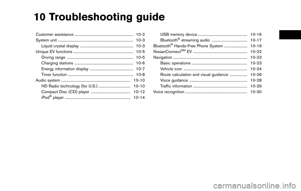
10 Troubleshooting guide
Customer assistance ............................................................. 10-2
System unit ........................................................................\
...... 10-3Liquid crystal display ....................................................... 10-3
Unique EV functions .............................................................. 10-5 Driving range ..................................................................... 10-5
Charging stations ............................................................. 10-6
Energy information display ............................................. 10-7
Timer function .................................................................... 10-8
Audio system ........................................................................\
10-10 HD Radio technology (for U.S.) ................................. 10-10
Compact Disc (CD) player ......................................... 10-12
iPod
�Šplayer .................................................................... 10-14 USB memory device ................................................... 10-16
Bluetooth
�Šstreaming audio ..................................... 10-17
Bluetooth�ŠHands-Free Phone System ........................ 10-19
NissanConnectSMEV ........................................................ 10-22
Navigation ........................................................................\
..... 10-23 Basic operations .......................................................... 10-23
Vehicle icon .................................................................. 10-24
Route calculation and visual guidance .................. 10-26
Voice guidance ............................................................ 10-28
Traffic information ........................................................ 10-29
Voice recognition ................................................................ 10-30
Page 228 of 268
CUSTOMER ASSISTANCE
For assistance or to order updated map data,
contact the NISSAN NAVIGATION SYSTEM
HELPDESK. For other assistance or inquiries,
contact NISSAN Consumer Affairs Department
or NissanConnect
SMMobile Apps and EV
customer service. See the contact information
on the inside front cover of this manual.
10-2
10. Troubleshooting guide
Page 230 of 268
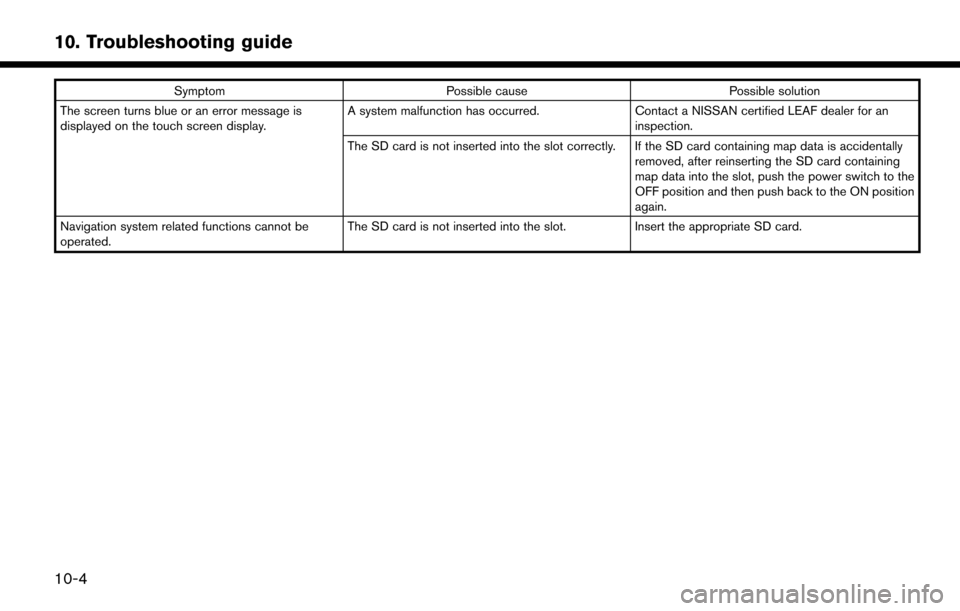
SymptomPossible cause Possible solution
The screen turns blue or an error message is
displayed on the touch screen display. A system malfunction has occurred.
Contact a NISSAN certified LEAF dealer for an
inspection.
The SD card is not inserted into the slot correctly. If the SD card containing map data is accidentally removed, after reinserting the SD card containing
map data into the slot, push the power switch to the
OFF position and then push back to the ON position
again.
Navigation system related functions cannot be
operated. The SD card is not inserted into the slot.
Insert the appropriate SD card.
10-4
10. Troubleshooting guide