2017 NISSAN GT-R phone
[x] Cancel search: phonePage 107 of 248

6 Navigation
Safety information ..................................................................... 6-3
Map operation ........................................................................\
.... 6-3Displaying current vehicle location ................................. 6-3
Map types ........................................................................\
...... 6-3
Road color ........................................................................\
..... 6-6
Moving map ........................................................................\
.. 6-6
Changing scale of map ...................................................... 6-7
Changing map ...................................................................... 6-8
Map view settings ............................................................... 6-9
Setting information on map ............................................ 6-12Traffic information on map .............................................. 6-13
Map Menu screen ............................................................ 6-13
Setting destination ................................................................. 6-14 Basic operations ............................................................... 6-14
Finding address ................................................................ 6-17
Finding nearby place ....................................................... 6-18
Finding points of interest ................................................ 6-19
Setting home as destination .......................................... 6-20
Searching from address book ....................................... 6-21
Searching from previous destinations ......................... 6-21
Searching by connecting to the internet (if
so equipped) ..................................................................... 6-22
Setting intersection .......................................................... 6-22
Setting by phone number ............................................... 6-22
Setting city center ............................................................ 6-23 Setting freeway entrance/exit ...................................... 6-23
Setting from stored routes ........................................... 6-24
Setting point on map ..................................................... 6-24
Setting with NissanConnect
SMServices (if
so equipped) ................................................................... 6-25
Options before starting the route guidance ............ 6-26
Route guidance ...................................................................... 6-27
About route guidance ................................................... 6-27
Route menu ..................................................................... 6-33
Setting new destination ................................................ 6-35 Canceling Route ............................................................. 6-35
Confirming route ............................................................. 6-35
Editing route .................................................................... 6-36Recalculating route ........................................................ 6-38
Searching for detour route using
traffic information ............................................................ 6-38
Setting detour route ...................................................... 6-39
Route guidance settings .............................................. 6-39
Viewing traffic information ................................................... 6-43
Viewing available traffic information ........................... 6-43
Traffic information setting ............................................. 6-45
Storing a location/route ....................................................... 6-46 Storing location .............................................................. 6-46
Storing route ................................................................... 6-47
Storing avoid area .......................................................... 6-47
Page 122 of 248
![NISSAN GT-R 2017 R35 Multi Function Display Owners Manual 6. Navigation
[Phone Number]Searches for a point of interest by a telephone number.“Setting by phone number” (page 6-22)
[City Center] Sets the center of a city as the destination.
“Setting city NISSAN GT-R 2017 R35 Multi Function Display Owners Manual 6. Navigation
[Phone Number]Searches for a point of interest by a telephone number.“Setting by phone number” (page 6-22)
[City Center] Sets the center of a city as the destination.
“Setting city](/manual-img/5/524/w960_524-121.png)
6. Navigation
[Phone Number]Searches for a point of interest by a telephone number.“Setting by phone number” (page 6-22)
[City Center] Sets the center of a city as the destination.
“Setting city center” (page 6-23)
[Freeway Entrance/Exit] Sets a freeway entrance/exit as a destination.
“Setting freeway entrance/exit” (page 6-23)
[Stored Routes] Sets a route from the stored route data.
“Setting from stored routes” (page 6-24)
INFO:
. After setting a destination, the location of the
destination can be adjusted and the location
can be stored in the Address Book, etc.
“Options before starting the route
guidance” (page 6-26)
. The destination can be deleted.
“Canceling Route” (page 6-35)
6-16
Page 128 of 248
![NISSAN GT-R 2017 R35 Multi Function Display Owners Manual 6. Navigation
4. Touch [Start] to start route guidance.
Voice command
1. Push <
>located on the steering wheel.
2. After the tone sounds, speak a command.
Use the following voice commands to display t NISSAN GT-R 2017 R35 Multi Function Display Owners Manual 6. Navigation
4. Touch [Start] to start route guidance.
Voice command
1. Push <
>located on the steering wheel.
2. After the tone sounds, speak a command.
Use the following voice commands to display t](/manual-img/5/524/w960_524-127.png)
6. Navigation
4. Touch [Start] to start route guidance.
Voice command
1. Push <
>located on the steering wheel.
2. After the tone sounds, speak a command.
Use the following voice commands to display the
previous destinations/start point list:
“Previous Destinations”
“Previous Start Point”
SEARCHING BY CONNECTING TO
THE INTERNET (if so equipped)
It is possible to find a point of interest by
inputting a keyword and connecting to the
Internet. The searched location can be set as a
destination.
1. Touch [Navi] on the Launch Bar.
2. Touch [Connected Search].
3. Enter the keyword and touch [Search]. The system will connect to the NissanConnect
SM
Services and the search results will be
displayed.
4. Touch the preferred destination from the list.
5. The entire destination is displayed. Touch [Start] to start route guidance.
INFO:
Connected Search is a NissanConnect
SMSer-
vices feature. It is necessary to subscribe to
NissanConnect
SMServices in order to use the
feature.
SETTING INTERSECTION
It is possible to set an intersection of any two
streets as the destination and have the system
calculate a route.
1. Touch [Navi] on the Launch Bar.
2. Touch [Intersection]. Intersection screen is displayed.
3. Input the Intersection.
.Touch [State/Province] to enter the state
or province name if necessary.
.Touch [City] to enter the city name.
.Touch [1st Street] to enter the first streetname. After finishing the entry, touch [List]. A list screen is displayed.
.After first street information is entered,
touch [2nd Street] to enter the second
street name. After finishing the entry,
touch [List]. A list screen is displayed.
4. Enter the state/province, city, and street of the destination and then touch [OK]. The
route is displayed.
5. The selected destination is displayed at the center of the map. Touch [Start] to start route
guidance.
Voice command
1. Push <
>located on the steering wheel.
2. After the tone sounds, speak a command.
Use the following voice command to set an
intersection as destination:
“Intersections”*
*: This voice command operation is available only
when the language setting is set to English.
SETTING BY PHONE NUMBER
If the phone number of a facility is known, it is
possible to search for a facility by entering the
phone number.
6-22
Page 129 of 248

INFO:
. If the area code of the specified telephone
number does not exist in the map data, the
system cannot search for the location.
. Only the locations included in the database
in the map data can be searched for by
phone number. Residential phone numbers
cannot be used to search for a location.
1. Touch [Navi] on the Launch Bar.
2. Touch [Phone Number]. The telephone number input screen is displayed.
3. Enter the telephone number including the area code. After finishing entry, touch [OK].
4. The selected destination is displayed. Touch [Start] after confirming the location of the
displayed destination.
INFO:
If there are more than one location registered for
the phone number, a list screen is displayed.
Touch an item on the list to select a preferred
location.
SETTING CITY CENTER
It is possible to set the center of a specified city
as a destination.
1. Touch [Navi] on the Launch Bar.
2. Touch [City Center]. A character input screen is displayed.
3. Enter the name of the city and touch [List]. A list screen is displayed.
INFO:
Touch [Last 5 Cities] to display the last 5
cities recently set as destinations.
4. Touch the preferred destination from the list.
INFO:
Touch [By Distance] to sort the list by the
nearest distance. Touch [By Name] to sort
the list by the alphabetic order.
5. The selected destination is displayed on the map. Touch [Start] after confirming the
location of the displayed destination.
Voice command
1. Push <
>located on the steering wheel.
2. After the tone sounds, speak a command.
Use the following voice command to set city
center as a destination:
“City Center”*
*: This voice command operation is available only
when the language setting is in English.
SETTING FREEWAY ENTRANCE/
EXIT
It is possible to set the destination to an entrance
or exit of a freeway.
1. Touch [Navi] on the Launch Bar.
2. Touch [Freeway Entrance/Exit] to display the keyboard input screen.
3. Enter the name of the freeway. After finishing entry, touch [List].
4. Touch the preferred freeway.
6. Navigation
6-23
Page 133 of 248
![NISSAN GT-R 2017 R35 Multi Function Display Owners Manual around the destination. Touch [Call] (when
available) to make a phone call to the facility
set as a destination.ROUTE GUIDANCE
ABOUT ROUTE GUIDANCE
After setting the route, select [Start] to start the NISSAN GT-R 2017 R35 Multi Function Display Owners Manual around the destination. Touch [Call] (when
available) to make a phone call to the facility
set as a destination.ROUTE GUIDANCE
ABOUT ROUTE GUIDANCE
After setting the route, select [Start] to start the](/manual-img/5/524/w960_524-132.png)
around the destination. Touch [Call] (when
available) to make a phone call to the facility
set as a destination.ROUTE GUIDANCE
ABOUT ROUTE GUIDANCE
After setting the route, select [Start] to start the
route guidance.
Throughout the route guidance, the system
navigates you through the guide points using
visual and voice guidance.
WARNING
. The navigation system’s visual and
voice guidance is for reference pur-
poses only. The contents of the
guidance may be inappropriate de-
pending on the situation.
. Follow all traffic regulations when
driving along the suggested route
(e.g., one-way traffic) .
“Route guidance” (page 6-62)
Voice guidance during route guidance
Basics of voice guidance:
Voice guidance announces which direction to
turn when approaching an intersection for which
a turn is necessary.
INFO:
. There may be some cases in which voice
guidance and actual road conditions do not
correspond. This may occur because of
discrepancies between the actual road and
the information on the map data, or may also
be due to the vehicle speed.
. In case voice guidance does not correspond
to the actual road conditions, follow the
information obtained from traffic signs or
notices on the road.
. Route guidance provided by the navigation
system does not take carpool lane driving
into consideration, especially when carpool
lanes are separated from other road lanes.
. The system will announce street names
when the system language is set to English.
Street names are not announced when the
system is set to French or Spanish.
INFO:
. When approaching a guide point (intersec-
tion or corner) , destination, etc. during route
guidance, voice guidance announces the
remaining distance and/or turning direction.
Push and hold
Page 155 of 248
![NISSAN GT-R 2017 R35 Multi Function Display Owners Manual Editing stored home and location
1. Touch [Settings] on the Launch Bar.
2. Touch [Navigation] and touch [Address Book].
Setting itemAction
[Home Location]* [Edit] [Show Icon on Map]Displays the icon o NISSAN GT-R 2017 R35 Multi Function Display Owners Manual Editing stored home and location
1. Touch [Settings] on the Launch Bar.
2. Touch [Navigation] and touch [Address Book].
Setting itemAction
[Home Location]* [Edit] [Show Icon on Map]Displays the icon o](/manual-img/5/524/w960_524-154.png)
Editing stored home and location
1. Touch [Settings] on the Launch Bar.
2. Touch [Navigation] and touch [Address Book].
Setting itemAction
[Home Location]* [Edit] [Show Icon on Map]Displays the icon of home location on the map.
[Icon] Selects a home icon of a preferred design.
[Sound] Sets the type of the alarm that sounds when the vehicle
approaches home.
[Direction] Sets the alarm to sound when approaching from a specific
direction.
[Distance] Sets the alarm to sound when reaching a specific distance to
home.
[Phone No.] Stores the home telephone number.
[Move Location] Adjusts the stored home location.
[Delete] Deletes the stored home location.
[OK] Confirms and saves the edited home information.
[Stored Locations] [Sort] [Sorted By Number]Sorts the stored locations.
“Searching from address book” (page 6-21)
[Sorted By Name]
[Sorted By Icon]
[Sorted By Group]
[Add New] Adds a new location.
“Storing location by searching” (page 6-46)
Stored Location List [Edit] [Show Icon on Map] Displays the icon of a stored location on the map.
[Name]Registers a name of the entry.
6. Navigation
6-49
Page 156 of 248
![NISSAN GT-R 2017 R35 Multi Function Display Owners Manual 6. Navigation
[Voicetag]Registers a voicetag for the entry which allows the entry to be
used with the voice recognition system.
[Icon] Selects an icon for the entry.
[Sound] Sets the type of the alarm NISSAN GT-R 2017 R35 Multi Function Display Owners Manual 6. Navigation
[Voicetag]Registers a voicetag for the entry which allows the entry to be
used with the voice recognition system.
[Icon] Selects an icon for the entry.
[Sound] Sets the type of the alarm](/manual-img/5/524/w960_524-155.png)
6. Navigation
[Voicetag]Registers a voicetag for the entry which allows the entry to be
used with the voice recognition system.
[Icon] Selects an icon for the entry.
[Sound] Sets the type of the alarm that sounds when the vehicle
approaches the location.
[Direction] Sets the alarm to sound when approaching from a specific
direction.
[Distance] Sets the alarm to sound when reaching a specific distance to
the location.
[Phone No.] Registers a phone number of the location.
[Group] Registers a group of the entry.
[Entry Number] Registers an entry number for the location.
[Move Location] Adjusts the stored location information.
[Delete] Deletes the stored location information.
[OK] Confirms and saves the edited stored location information.
*: When home location has not been stored, [Home Location (None)] is displayed and a home location can be stored from the menu.
6-50
Page 164 of 248

6. Navigation
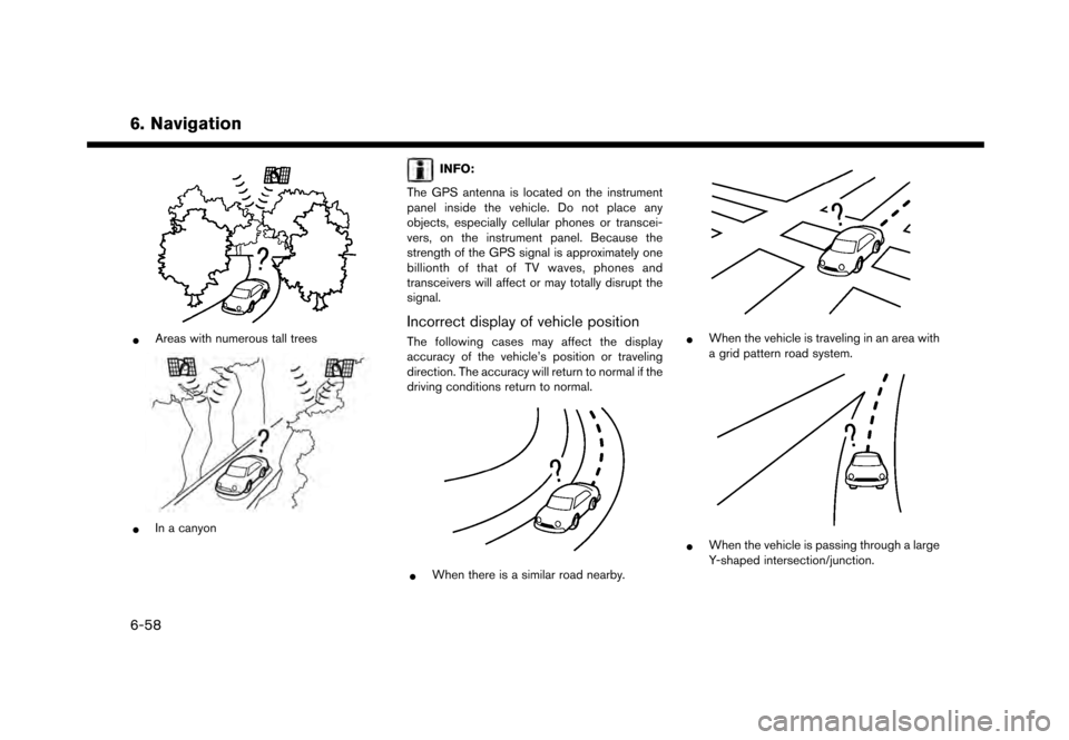
*Areas with numerous tall trees
*In a canyon
INFO:
The GPS antenna is located on the instrument
panel inside the vehicle. Do not place any
objects, especially cellular phones or transcei-
vers, on the instrument panel. Because the
strength of the GPS signal is approximately one
billionth of that of TV waves, phones and
transceivers will affect or may totally disrupt the
signal.
Incorrect display of vehicle position
The following cases may affect the display
accuracy of the vehicle’s position or traveling
direction. The accuracy will return to normal if the
driving conditions return to normal.
*When there is a similar road nearby.
*When the vehicle is traveling in an area with
a grid pattern road system.
*When the vehicle is passing through a large
Y-shaped intersection/junction.
6-58