2017 NISSAN GT-R ESP
[x] Cancel search: ESPPage 102 of 248
5. Information
— The TCU (Telematics Control Unit)or other systems of your vehicle
are not working properly.
— It may not be possible to make an emergency call depending on the
severity of a collision and/or emer-
gency.
. Park the vehicle in a safe location
and set the parking brake before
operating
. Only use this service in case of an
emergency. There may be a penalty
for inappropriate use of the service.
. Radio waves could adversely affect
electric medical equipment. Indivi-
duals who use a pacemaker should
contact the device manufacturer re-
garding any possible effects before
using the system.
. The TCU (Telematics Control Unit)
antenna is installed inside the upper
central part of the instrument panel.
An occupant should not get any
closer to the antenna than specified
by the pacemaker manufacturer. The
radio waves from the TCU antenna
may adversely affect the operation of
the pacemaker while using the Nis- sanConnectSMServices.
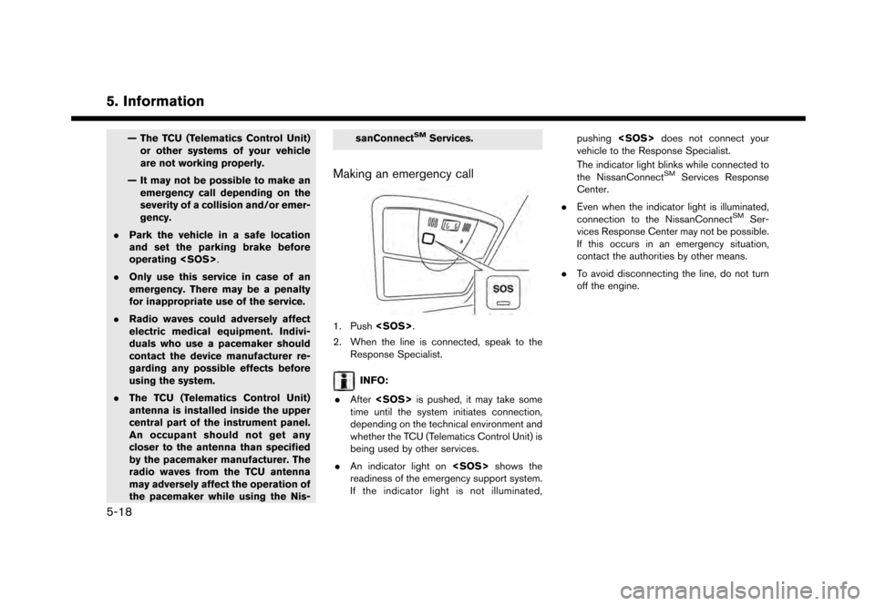
Making an emergency call
1. Push
2. When the line is connected, speak to the Response Specialist.
INFO:
. After
time until the system initiates connection,
depending on the technical environment and
whether the TCU (Telematics Control Unit) is
being used by other services.
. An indicator light on
readiness of the emergency support system.
If the indicator light is not illuminated, pushing
vehicle to the Response Specialist.
The indicator light blinks while connected to
the NissanConnect
SMServices Response
Center.
. Even when the indicator light is illuminated,
connection to the NissanConnect
SMSer-
vices Response Center may not be possible.
If this occurs in an emergency situation,
contact the authorities by other means.
. To avoid disconnecting the line, do not turn
off the engine.
5-18
Page 105 of 248
SiriusXM Travel Link.
. Not all vehicles or devices are capable of
receiving all services offered by SiriusXM.
Data displays and individual product avail-
ability vary by vehicle hardware. Current
information and features may not be available
in all locations, or on all receivers. SiriusXM is
not responsible for any errors or inaccuracies
in the data services or their use in the vehicle.
Notes on SiriusXM Traffic information
.The SiriusXM Traffic information service is
not provided for some cities. In addition, the
cities for which the traffic information service
is provided may be changed.
. In some cases, infrastructure problems may
prevent the complete display of the traffic
information. This is not a malfunction.
. Due to infrastructure problems, or due to the
time when the traffic information service
broadcast is received, the displayed informa-
tion may differ from the actual traffic condi-
tions.
. Depending on the traffic information, a
detour route may be slower than the original
route. .
SiriusXM Satellite Radio and SiriusXM Traffic
subscriptions are sold separately or as a
package, and are continuous until you call
SiriusXM to cancel. See SiriusXM Customer
Agreement for complete terms at the Sir-
iusXM website.
SiriusXM website:
For U.S.
www. siriusxm.com
For Canada
www.siriusxm.ca (English)
www.siriusxm.ca/fr (French)
SiriusXM Travel Link is available in select
markets. For more information, refer to the
SiriusXM website or call Listener Care.
SiriusXM website:
For U.S.
www.siriusxm.com/traffic
For Canada
www.siriusxm.ca/siriusxm-traffic-services/
siriusxm-travel-link (English)
www.siriusxm.ca/fr/services-siriusxm-
traffic/siriusxm-travel-link (French)
Listener Care:
For U.S. 1-877-447-0011
For Canada
1-877-438-9677
. SiriusXM Traffic is available in over 130
metropolitan markets. For the most current
list of markets covered, please refer to the
SiriusXM website or call Listener Care.
SiriusXM website:
For U.S.
www.siriusxm.com/siriusxmtraffic
For Canada
www.siriusxm.ca/siriusxm-traffic-services/
siriusxm-traffic (English)
www.siriusxm.ca/fr/services-siriusxm-
traffic/siriusxm-traffic (French)
Listener Care:
For U.S.
1-877-447-0011
For Canada
1-877-438-9677
. Due to road maintenance, infrastructure
problems (e.g. malfunction of road sensors,
outage of central computer of infrastructure)
or natural disasters, there are times when
some or all traffic information may not be
5. Information
5-21
Page 119 of 248
the place.
TRAFFIC INFORMATION ON MAP
With a subscription to SiriusXM Traffic, traffic
information is displayed.
“Traffic information on map” (page 6-44)
Free Flow: Green arrow
Moderate traffic: Yellow arrow
Heavy traffic: Red
Section affected by serious traffic event: Purple
The following traffic information icons may be
displayed.
: Accident
: Closed road
: Information
: Road work
: Slippery road
: Weather
: Incident
INFO:
Traffic icons are displayed in the scale level of
1/64 miles (25 m) - 5 miles (10 km) range. Some
traffic icons are displayed only on the map at
higher detail levels.
MAP MENU SCREEN
Touch [] while the current location map
screen or a scrolled map screen is displayed to
display the menu corresponding to that screen.
This menu can be used to quickly access helpful
functions, such as setting a destination and
searching for points of interest nearby.
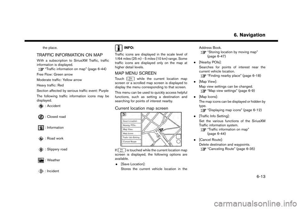
Current location map screen
If [] is touched while the current location map
screen is displayed, the following options are
available.
. [Save Location]:
Stores the current vehicle location in the Address Book.
“Storing location by moving map”
(page 6-47)
. [Nearby POIs]:
Searches for points of interest near the
current vehicle location.
“Finding nearby place” (page 6-18)
. [Map View]:
Map view settings can be changed.
“Map view settings” (page 6-9)
. [Map Icons]:
The map icons can be displayed or hidden by
type.
“Displaying map icons” (page 6-12)
. [Traffic Info Setting]:
Set the various functions of the SiriusXM
Traffic information system.
“Traffic information on map”
(page 6-44)
. [Cancel Route]:
Delete destination and waypoints.
“Canceling Route” (page 6-35)
6. Navigation
6-13
Page 126 of 248
6. Navigation
Voice command
1. Push <
>located on the steering wheel.
2. After the tone sounds, speak a command.
Use the following voice command to search for
Points of Interest from a facility name:
“Points of Interest
*: This voice command operation is available only
when the language setting is set to English.
Searching Points of Interest by cate-
gory
1. Touch [Navi] on the Launch Bar.
2. Touch [Points of Interest]. The main category menu is displayed.
3. Touch the main category. The subcategory list is displayed.
4. Touch the subcategory. Narrow down con- dition screen is displayed.
5. Touch the narrow down category. Search conditions:
.[By Name]:Enter the name of the facility
.[Select a City]:Input the city to narrow down the target
city.
.[Near Current Location]:
Facilities near the current vehicle location
are displayed in a list.
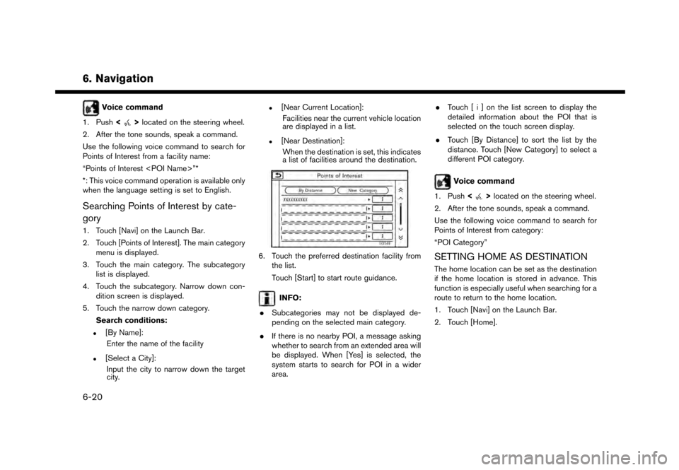
.[Near Destination]:When the destination is set, this indicates
a list of facilities around the destination.
6. Touch the preferred destination facility from the list.
Touch [Start] to start route guidance.
INFO:
. Subcategories may not be displayed de-
pending on the selected main category.
. If there is no nearby POI, a message asking
whether to search from an extended area will
be displayed. When [Yes] is selected, the
system starts to search for POI in a wider
area. .
Touch [ i ] on the list screen to display the
detailed information about the POI that is
selected on the touch screen display.
. Touch [By Distance] to sort the list by the
distance. Touch [New Category] to select a
different POI category.
Voice command
1. Push <
>located on the steering wheel.
2. After the tone sounds, speak a command.
Use the following voice command to search for
Points of Interest from category:
“POI Category”
SETTING HOME AS DESTINATION
The home location can be set as the destination
if the home location is stored in advance. This
function is especially useful when searching for a
route to return to the home location.
1. Touch [Navi] on the Launch Bar.
2. Touch [Home].
6-20
Page 131 of 248
INFO:
If a point on a freeway is set as the destination, a
confirmation message is displayed.
SETTING WITH NISSANCON-
NECTSMSERVICES (if so equipped)
It is possible to set the destination using the
NissanConnectSMServices features.“NissanConnectSMServices” (page 5-9)
INFO:
Use of NissanConnect
SMServices features is
dependent upon a valid subscription and the
telematics device being in operative condition, as
well as cellular connectivity, navigation map data
and GPS satellite signal reception being avail-
able.
Setting from information feeds
If the downloaded NissanConnectSMServices
information feed has location data, you can set it
as a destination. It is also possible to use
NissanConnect
SMServices features such as
“Destination Download”, “Send to Car” or
“Journey Planner”, etc. to set a destination.
For details of the services and settings, refer to
NissanConnect
SMServices website or contact
the NissanConnectSMServices support line. NissanConnect
SMServices website:
For U.S.
www.nissanusa.com/connect
For Canada
www.nissan.ca/nissanconnect (English)
www.nissan.ca/nissanconnect/fr (French)
NissanConnect
SMServices support
line:
1-855-426-6628
1. Touch [Info] on the Launch Bar.
2. Touch [NissanConnect Services].
3. Touch [All Information Feeds]. A list screen is displayed.
4. Touch a preferred folder. A list of information feeds is displayed.
5. Touch a preferred information feed.
INFO:
The methods for setting a destination differ
depending on the specific service (Roadside
Assistance Service, Assisted Search, Destina-
tion Download, Connected Search, etc.) and
NissanConnect
SMServices may be updated
during ownership. Please see the NissanCon- nect
SMServices website for the latest features
and services, as well as the most up-to-date user
guide. NissanConnect
SMServices website:
For U.S.
www.nissanusa.com/connect
For Canada
www.nissan.ca/nissanconnect (English)
www.nissan.ca/nissanconnect/fr (French)
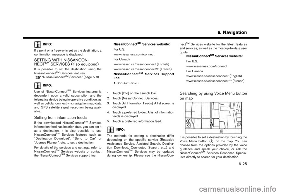
Searching by using Voice Menu button
on map
It is possible to set a destination by touching the
Voice Menu button
*1on the map. You can
choose from the options provided by the voice
guidance and speak your choice, or ask the
NissanConnect
SMServices Response Specia-
lists directly to search for your destination.
6. Navigation
6-25
Page 133 of 248
![NISSAN GT-R 2017 R35 Multi Function Display Owners Manual around the destination. Touch [Call] (when
available) to make a phone call to the facility
set as a destination.ROUTE GUIDANCE
ABOUT ROUTE GUIDANCE
After setting the route, select [Start] to start the NISSAN GT-R 2017 R35 Multi Function Display Owners Manual around the destination. Touch [Call] (when
available) to make a phone call to the facility
set as a destination.ROUTE GUIDANCE
ABOUT ROUTE GUIDANCE
After setting the route, select [Start] to start the](/manual-img/5/524/w960_524-132.png)
around the destination. Touch [Call] (when
available) to make a phone call to the facility
set as a destination.ROUTE GUIDANCE
ABOUT ROUTE GUIDANCE
After setting the route, select [Start] to start the
route guidance.
Throughout the route guidance, the system
navigates you through the guide points using
visual and voice guidance.
WARNING
. The navigation system’s visual and
voice guidance is for reference pur-
poses only. The contents of the
guidance may be inappropriate de-
pending on the situation.
. Follow all traffic regulations when
driving along the suggested route
(e.g., one-way traffic) .
“Route guidance” (page 6-62)
Voice guidance during route guidance
Basics of voice guidance:
Voice guidance announces which direction to
turn when approaching an intersection for which
a turn is necessary.
INFO:
. There may be some cases in which voice
guidance and actual road conditions do not
correspond. This may occur because of
discrepancies between the actual road and
the information on the map data, or may also
be due to the vehicle speed.
. In case voice guidance does not correspond
to the actual road conditions, follow the
information obtained from traffic signs or
notices on the road.
. Route guidance provided by the navigation
system does not take carpool lane driving
into consideration, especially when carpool
lanes are separated from other road lanes.
. The system will announce street names
when the system language is set to English.
Street names are not announced when the
system is set to French or Spanish.
INFO:
. When approaching a guide point (intersec-
tion or corner) , destination, etc. during route
guidance, voice guidance announces the
remaining distance and/or turning direction.
Push and hold
Page 164 of 248
6. Navigation
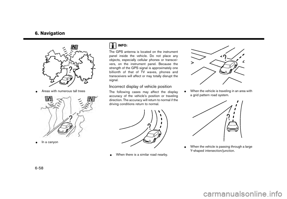
*Areas with numerous tall trees
*In a canyon
INFO:
The GPS antenna is located on the instrument
panel inside the vehicle. Do not place any
objects, especially cellular phones or transcei-
vers, on the instrument panel. Because the
strength of the GPS signal is approximately one
billionth of that of TV waves, phones and
transceivers will affect or may totally disrupt the
signal.
Incorrect display of vehicle position
The following cases may affect the display
accuracy of the vehicle’s position or traveling
direction. The accuracy will return to normal if the
driving conditions return to normal.
*When there is a similar road nearby.
*When the vehicle is traveling in an area with
a grid pattern road system.
*When the vehicle is passing through a large
Y-shaped intersection/junction.
6-58
Page 168 of 248
6. Navigation
— The endpoint of the route may not exactlymatch the destination.
— If you calculate a route on a main road, the system may display a route from another
main road. This may be because the
position of the vehicle icon is not accu-
rate. In this case, park the vehicle in a safe
location and reset the vehicle icon, or
continue driving to see if the position of
the vehicle icon is automatically adjusted
before recalculating the route.
— There are cases in which the system shows an indirect route to reach the
destination or waypoints, if you set them
from stored or facility information. In order
to correct this, you must be careful about
the traffic direction, especially when lanes
with different travel directions are shown
separately, such as interchanges and
service areas.
— This system makes no distinction be- tween limited traffic control and total
control (blockage) . It may show an
indirect route even if the road is usable.
— Even if the ferry preference is set to OFF, a route that uses a ferry line may be
suggested.ROUTE GUIDANCE
INFO:
The system will announce street names when the
system language is set to English. Street names
are not announced when the system is set to
French or Spanish.
Repeating voice guidance
This function is available throughout route
guidance, from the time after the route calcula-
tion is completed until the vehicle arrives at the
destination. Push and hold