Page 4 of 145

3
Quick Reference GuideHOME Screen
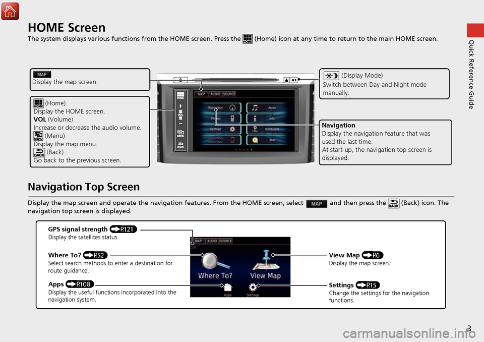
The system displays various functions from the HOME screen. Press the (Home) icon at any time to return to the main HOME scree n.
Navigation Top Screen
Display the map screen and operate the navigation features. From the HOME screen, select and then press the (Back) icon. The
navigation top screen is displayed.
(Home)
Display the HOME screen.
VOL (Volume)
Increase or decrease the audio volume.
(Menu)
Display the map menu. (Back)
Go back to the previous screen.
(Display Mode)
Switch between Da y and Night mode
manually.
Navigation
Display the navigati on feature that was
used the last time.
At start-up, the navi gation top screen is
displayed.
Display the map screen.
GPS signal strength (P121)Display the satellites status.
Where To? (P52)Select search methods to enter a destination for
route guidance.
Apps (P108)Display the useful functions incorporated into the
navigation system.
View Map (P6)Display the map screen.
Settings (P15)Change the settings for the navigation
functions.
Page 8 of 145
7
Quick Reference GuideDuring Route Guidance
During route guidance, route information is displayed on the map screen.
You can see the detailed information on the turn information screen.
Map Screen
Guidance Screen
Dashboards (P75)
Next guidance indicator
(P75)
Distance to the next guidance point and street name of
next guidance point.
Where To? (P52)
Waypoint
Calculated route
Speed limit Cancel route
Street name of next
guidance point
Distance to next guidance point
Estimated time to
next guidance point
Scrolls key
Select this key to scroll
the display.
Day or Night Mode
Press the (Display mode) icon to
manually switch between Day and
Night mode.
Turn-by-Turn Directions
The next guidance point appears on
the upper Audio/Information Display.
Day ModeNight Mode
Remaining
distance
Street name of next
guidance point
Next driving manoeuvre is
approaching
Page 12 of 145

11
Quick Reference GuideVoice Control Operation
Voice Portal Screen
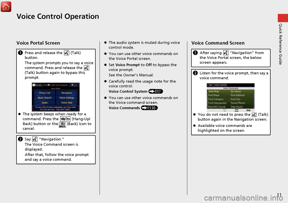
aPress and release the (Talk)
button.
The system prompts you to say a voice
command. Press and release the
(Talk) button again to bypass this
prompt.
The system beeps when ready for a
command. Press the (Hang-Up/
Back) button or the (Back) icon to
cancel.
b Say “ Navigation .”
The Voice Command screen is
displayed.
After that, follow the voice prompt
and say a voice command.
The audio system is muted during voice
control mode.
You can use other voice commands on
the Voice Portal screen.
Set Voice Prompt to Off to bypass the
voice prompt.
See the Owner's Manual.
Carefully read the usage note for the
voice control.
Voice Control System (P17)
You can use other voice commands on
the Voice command screen.
Voice Commands (P138)Voice Command Screen
aAfter saying “Navigation ” from
the Voice Portal screen, the below
screen appears.
b Listen for the voice prompt, then say a
voice command.
You do not need to press the (Talk)
button again in the Navigation screen.
Available voice commands are
highlighted on the screen.
Page 46 of 145
45
uuOther Settings uLanguage & Keyboard
Continued
System Setup
Language & Keyboard
H u (Back) uSettings uLanguage & Keyboard
Set the language for the uni t and the keyboard layout.
Select an option.
The following options are available:
• Voice Language : Sets the language for voice prompts.
2Voice Language P. 46
•Keyboard Language : Sets the language for your keyboard.
2Keyboard Language P. 46
•Keyboard Layout: Sets the keyboard layout.
2 Keyboard Layout P. 47
1Language & Keyboard
When you select a language for the audio system, the
language setting of the navigation system is
automatically switched.
See the Owner’s Manual for instructions.
Page 77 of 145

uuDriving to Your Destination uViewing the Route
76
Navigation
• Select the map dashboards when you want to change the information that is
displayed. Select the following options:
Arrival Time , Distance , Time to Destination , Via Arrival , Distance to Via ,
Time to Via , Direction of Travel , Elevation.
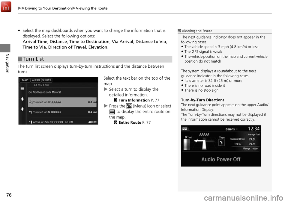
The turn list screen displays turn-by-turn instructions and the distance between
turns.
Select the text bar on the top of the
map.
uSelect a turn to display the
detailed information.
2Turn Information P. 77
uPress the (Menu) icon or select
to display the entire route on
the map.
2 Entire Route P. 77
■Turn List
1
Viewing the Route
The next guidance indicator does not appear in the
following cases.
•The vehicle speed is 3 mph (4.8 km/h) or less
•The GPS signal is weak•The vehicle position on the map and current vehicle
position do not match
The system displays a roundabout to the next
guidance indicator in the following cases.
•Its diameter is 82 ft (25 m) or more•There is no road inside it
•There is no stop sign
Turn-by-Turn Directions
The next guidance point ap pears on the upper Audio/
Information Display.
The Turn-by-Turn directions may not be displayed if
the information cannot be received correctly.
Page 131 of 145

130
Reference Information
System Limitations
GPS
The signals received from the GPS satellites
are extremely weak (less than a millionth of
the strength of a local FM station) and
require an unobstructed view of the sky.
The GPS antenna is located in the
dashboard. The signal reception can easily
be interrupted or interfered with by the
following:
• Metallic window tint on the front or side windows
• Cellular phones, PDAs, or other electronic devices docked in a cradle or lying loose
on the dashboard
• Remote starters or “hidden” vehicle tracking systems mounted near the
navigation unit
• Audio electronic devices mounted near the navigation unit
• Trees, tall buildings, highway overpasses,
tunnels, or overhead electrical power
wires The GPS is operated by the U.S. Department
of Defense. For security reasons, there are
certain inaccuracies bui
lt into the GPS for
which the navigation system must
constantly compensate. This can cause
occasional positioning errors of up to
several hundred feet (meters).
Address Calculation
The destination icon shows only the
approximate location of a destination
address. This occurs if the number of
possible addresses is different from the
number of actual addr esses on a block. For
example, the address 1425 on a 1400 block
with 100 possible addresses (because it is
followed by the 1500 block) will be shown a
quarter of the way down the block by the
system. If there are only 25 actual addresses
on the block, the actual location of address
1425 would be at the end of the block.
Database
The digitized map database reflects
conditions as they existed at various points
in time before production. Accordingly,
your database may contain inaccurate or
incomplete data or information due to the
passage of time, road construction,
changing conditions, or other causes.
For example, some places/landmarks may
be missing when you search the database
because the name was misspelled, the place
was improperly categorized, or a place/
landmark is not yet in the database. This is
also true for police st ations, hospitals, and
other public institutions. Do not rely on the
navigation system if you need law
enforcement or hospital services. Always
check with local in formation sources.