Page 50 of 368

48
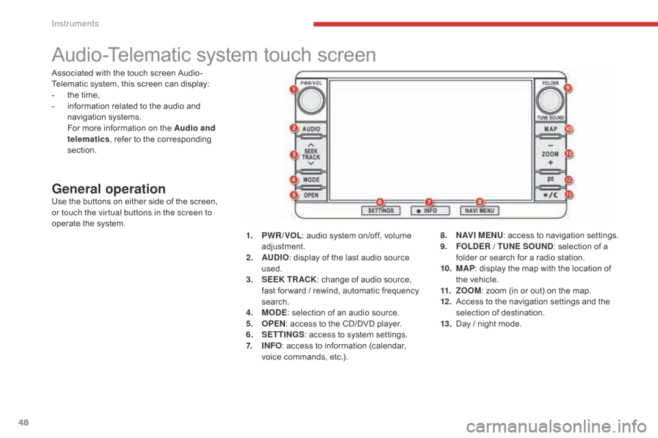
Audio-Telematic system touch screen
General operationUse the buttons on either side of the screen,
or touch the virtual buttons in the screen to
operate the system.1.
P
WR / VOL: audio system on/off, volume
adjustment.
2.
AU
DIO: display of the last audio source
used.
3.
S
EEK TR ACK: change of audio source,
fast for ward / rewind, automatic frequency
search.
4.
M
ODE: selection of an audio source.
5.
O
PEN: access to the CD/DVD player.
6.
S
ETTINGS: access to system settings.
7.
I
NFO: access to information (calendar,
voice commands, etc.). 8.
N
AV I M E NU: access to navigation settings.
9.
F
OLDER / TUNE SOUND: selection of a
folder or search for a radio station.
10.
M
AP: display the map with the location of
the vehicle.
11.
Z
OOM: zoom (in or out) on the map.
12 .
A
ccess to the navigation settings and the
selection of destination.
13.
D
ay / night mode.
Associated with the touch screen Audio-
Telematic system, this screen can display:
-
t
he time,
-
i
nformation related to the audio and
navigation systems.
F
or more information on the Audio and
telematics , refer to the corresponding
section.
Instruments
Page 128 of 368
126
C4-Aircross_en_Chap04_conduite_ed01-2016
Reversing camera
Linked with the navigation option, the reversing
camera complements the parking sensor
system and is activated automatically when
reverse gear is engaged.The image from the camera is displayed in the
navigation screen.
The zone (A)
represents the upper part of the
rear bumper.
The red line represents the distance of 50 cm
from the edge of the rear bumper.
The green lines represent the width of the
vehicle increased by 20 cm on each side.
The marks on the green lines correspond to the
edges of the rear bumper (B), then the distance
of 1 metre from the edge of the rear bumper (C)
and 2 metres (D) . In no circumstances can the reversing
camera replace the need for vigilance
on the part of the driver.
Clean the reversing camera from time
to time using a soft dry cloth.
High pressure jet wash
When washing your vehicle, do not
direct the lance to within 30 cm of the
camera lens.
Driving
Page 249 of 368
247
C4-Aircross_en_Chap10b_Mitsu6_ed01-2016
AUDIO-TELEMATIC TOUCH
SCREEN SYSTEM
The system is protected in such a way that it will only
operate in your vehicle.01 First steps - Control panel
For safety reasons, the driver must carry out operations
which require prolonged attention while the vehicle is
stationary.
When the engine is switched off and to prevent
discharging of the battery, the system switches off
following the activation of the energy economy mode.
CONTENTS
03
General
operation
04
Navigation
05
Media
06
Settings
07
Information p.
p.
p.
p.
p.
p.
p. 248
249
251
252
268
282
284
02
Steering mounted
controls p.
288
08
BLUETOOTH
® streaming - telephone
Page 250 of 368

01
248
C4-Aircross_en_Chap10b_Mitsu6_ed01-2016
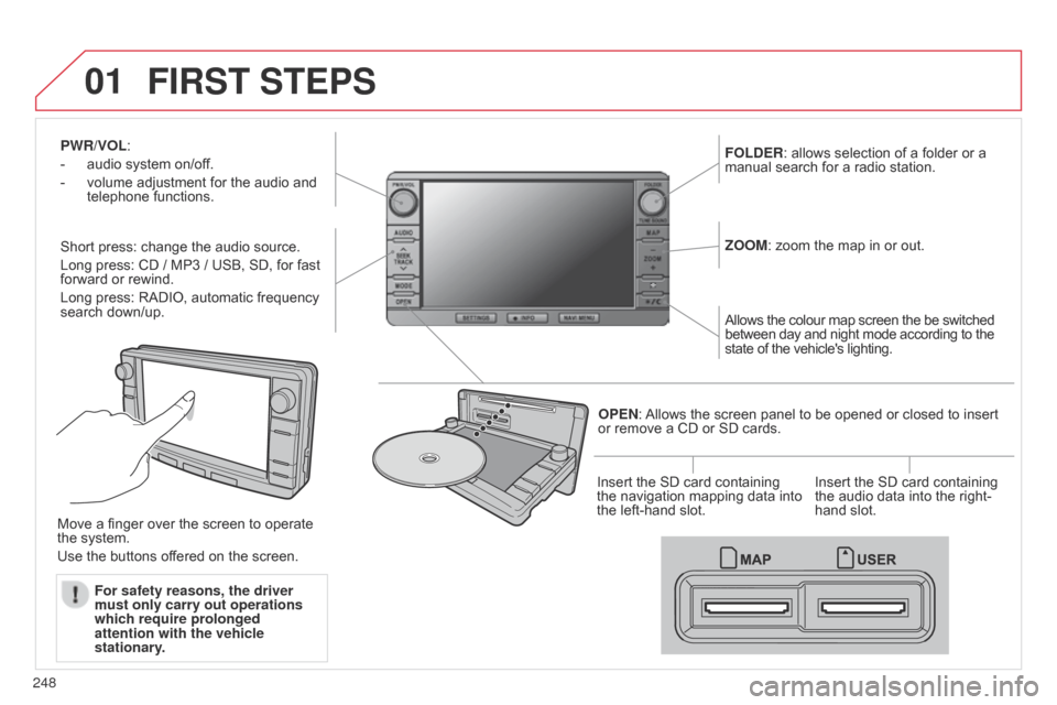
PWR/VOL:
-
audio system on/of
f.
-
volume adjustment for the audio and
telephone functions.
Short press: change the audio source.
Long press: CD / MP3 / USB, SD, for fast
forward or rewind.
Long press: RADIO, automatic frequency
search down/up. FOLDER
: allows selection of a folder or a
manual search for a radio station.
OPEN: Allows the screen panel to be opened or closed to insert
or remove a CD or SD cards. ZOOM: zoom the map in or out.
Allows the colour map screen the be switched
between day and night mode according to the
state of the vehicle's lighting.
Move a finger over the screen to operate
the system.
Use the buttons offered on the screen. For safety reasons, the driver
must only carry out operations
which require prolonged
attention with the vehicle
stationary. Insert the SD card containing
the navigation mapping data into
the left-hand slot.
Insert the SD card containing
the audio data into the right-
hand slot.
FIRST STEPS
Page 253 of 368
03
251
C4-Aircross_en_Chap10b_Mitsu6_ed01-2016
Description of the controls - Menus
SETTINGS: used to manage the
different adjustments.DESTINATION: used to set
navigation options and select the
destination.
NAVI MENU: used for adjustments
to the navigation system.
MODE: used to select the audio
source.
INFO: used to check information.
AUDIO: display the screen for the
last audio source used.
MAP: used to display the current
position of your vehicle on the map.
GENERAL
OPERATION
Page 264 of 368

04
262
C4-Aircross_en_Chap10b_Mitsu6_ed01-2016
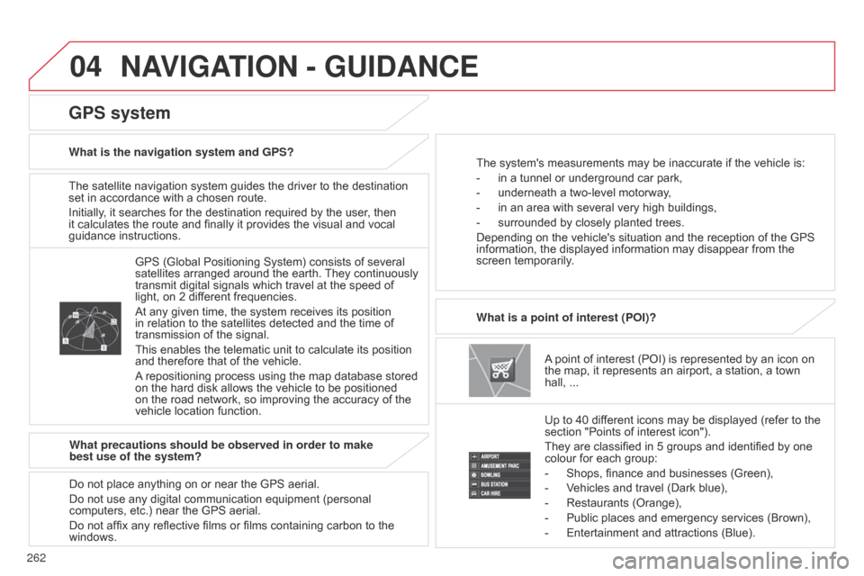
The satellite navigation system guides the driver to the destination
set in accordance with a chosen route.
Initially, it searches for the destination required by the user, then
it calculates the route and finally it provides the visual and vocal
guidance instructions.A point of interest (POI) is represented by an icon on
the map, it represents an airport, a station, a town
hall,
...
What is a point of interest (POI)?
Up to 40 different icons may be displayed (refer to the
section "Points of interest icon").
They are classified in 5 groups and identified by one
colour for each group:
-
Shops, finance and businesses (Green),
-
V
ehicles and travel (Dark blue),
-
Restaurants (Orange),
-
Public places and emergency services (Brown),
-
Entertainment and attractions (Blue).
GPS (Global Positioning System) consists of several
satellites arranged around the earth.
They continuously
transmit digital signals which travel at the speed of
light, on 2 different frequencies.
At any given time, the system receives its position
in relation to the satellites detected and the time of
transmission of the signal.
This enables the telematic unit to calculate its position
and therefore that of the vehicle.
A repositioning process using the map database stored
on the hard disk allows the vehicle to be positioned
on the road network, so improving the accuracy of the
vehicle location function.
GPS system
What is the navigation system and GPS? The system's measurements may be inaccurate if the vehicle is:
-
in a tunnel or underground car park,
-
underneath a two-level motorway
,
-
in an area with several very high buildings,
-
surrounded by closely planted trees.
Depending on the vehicle's situation and the reception of the GPS
information, the displayed information may disappear from the
screen temporarily
.
What precautions should be observed in order to make
best use of the system?
Do not place anything on or near the GPS aerial.
Do not use any digital communication equipment (personal
computers, etc.) near the GPS aerial.
Do not affix any reflective films or films containing carbon to the
windows.
NAVIGATION - GUIDANCE
Page 269 of 368

04
267
C4-Aircross_en_Chap10b_Mitsu6_ed01-2016
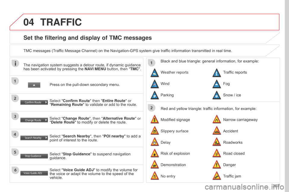
Set the filtering and display of TMC messages
TMC messages (Traffic Message Channel) on the Navigation-GPS system give traffic information transmitted in real time.Press on the pull-down secondary menu.
The navigation system suggests a detour route, if dynamic guidance
has been activated by pressing the
NAVI MENU button, then "TMC".
Select "Confirm Route" then "Entire Route" or
"Remaining Route" to validate or add to the route.
Select "Change Route", then "Alternative Route" or
"Delete Route" to modify or delete the route.
Select "Search Nearby ", then "POI nearby" to add a
point of interest to the route.
Select "Stop Guidance " to suspend navigation
guidance.
Select "Voice Guide ADJ" to modify the volume for
the voice or adapt the volume to the speed of the
vehicle. Red and yellow triangle: traffic information, for example:
Black and blue triangle: general information, for example:
Weather reports
Modified signage
Risk of explosion Traffic reports
Narrow carriageway
Road closed
Wind
Slippery surface
Demonstration Fog
Accident
Danger
Parking
Delay
No entry Snow / ice
Roadworks
Traffic jam
TRAFFIC
Page 289 of 368
287
C4-Aircross_en_Chap10b_Mitsu6_ed01-2016
Level 1Level 2 Level 3 Comments
Map Reg. Code Display the registration code for the navigation system.
Mobile Phone Make and receive telephone calls.
Version Info. View the software version and mapping data version.