2017 Acura MDX navigation
[x] Cancel search: navigationPage 335 of 369
334
TroubleshootingUpdate, Coverage, Map Errors
Troubleshooting
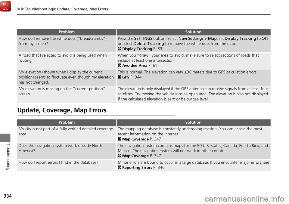
Update, Coverage, Map Errors
How do I remove the white dots (“breadcrumbs”)
from my screen?Press the SETTINGS button. Select Navi Settings > Map, set Display Tracking to Off
or select Delete Tracking to remove the white dots from the map.
2Display Tracking P. 83
A road that I selected to avoid is being used when
routing.When you “draw” your area to avoid, make sure to select sections of roads that
include at least one intersection.
2Avoided Area P. 61
My elevation (shown when I display the current
position) seems to fluctuate even though my elevation
has not changed.This is normal. The elevation can vary ±30 meters due to GPS calculation errors.
2GPS P. 344
My elevation is missing on the “current position”
screen.The elevation is only displayed if the GPS antenna can receive signals from at least four
satellites. Try moving the vehicle into an open area. The elevation is also not displayed
if the calculated elevation is zero or below sea level.
ProblemSolution
My city is not part of a full y verified detailed coverage
area.The mapping database is constantly undergoing revision. You can access the most
recent information on the internet.
2Map Coverage P. 347
Does the navigation system work outside North
America?The navigation system contains maps for the 50 U.S. states, Canada, Puerto Rico, and
Mexico. The navigation system will not work in other countries.
2Map Coverage P. 347
How do I report errors I find in the database?Minor errors are bound to occur in a large database. If you encounter major errors, see
2Reporting Errors P. 346
ProblemSolution
Page 336 of 369
335
TroubleshootingDisplay, Accessories
Troubleshooting
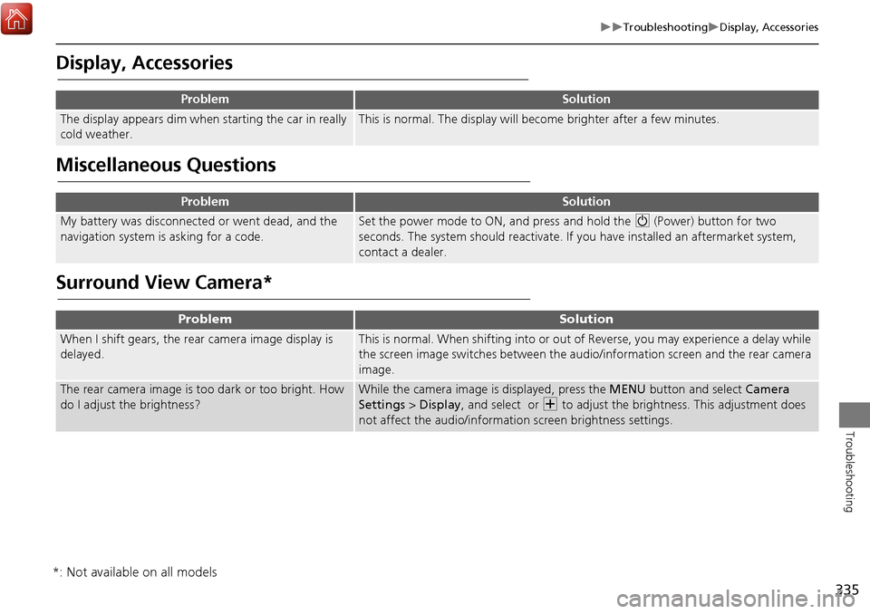
Display, Accessories
Miscellaneous Questions
Surround View Camera*
ProblemSolution
The display appears dim when starting the car in really
cold weather.This is normal. The display will become brighter after a few minutes.
ProblemSolution
My battery was disconnected or went dead, and the
navigation system is asking for a code.Set the power mode to ON, and press and hold the 9 (Power) button for two
seconds. The system should reactivate. If you have installed an aftermarket system,
contact a dealer.
ProblemSolution
When I shift gears, the rear camera image display is
delayed.This is normal. When shifting into or out of Reverse, you may experience a delay while
the screen image switches between the audio/information screen and the rear camera
image.
The rear camera image is t oo dark or too bright. How
do I adjust the brightness?While the camera image is displayed, press the MENU button and select Camera
Settings > Display , and select or N to adjust the brightness. This adjustment does
not affect the audio/informat ion screen brightness settings.
*: Not available on all models
Page 337 of 369
336
Troubleshooting
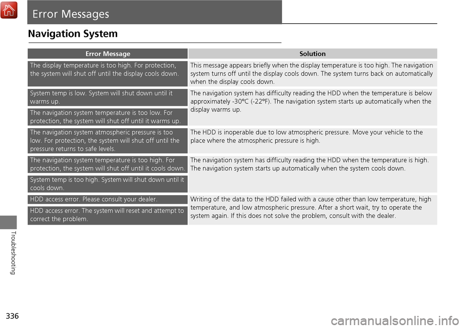
Error Messages
Navigation System
Error MessageSolution
The display temperature is too high. For protection,
the system will shut off until the display cools down.This message appears briefly when the display temperature is too high. The navigation
system turns off until the display cools down. The system turns back on automatically
when the display cools down.
System temp is low. System will shut down until it
warms up.The navigation system has difficulty readi ng the HDD when the temperature is below
approximately -30°C (-22°F). The navigation system starts up automatically when the
display warms up.
The navigation system temperature is too low. For
protection, the system will shut off until it warms up.
The navigation system atmospheric pressure is too
low. For protection, the syst em will shut off until the
pressure returns to safe levels.The HDD is inoperable due to low atmospheric pressure. Move your vehicle to the
place where the atmospheric pressure is high.
The navigation system temperature is too high. For
protection, the system will shut off until it cools down.The navigation system has difficulty reading the HDD when the temperature is high.
The navigation system starts up automatically when the system cools down.
System temp is too high. System will shut down until it
cools down.
HDD access error. Please consult your dealer.Writing of the data to the HDD failed with a cause other than low temperature, high
temperature, and low atmospheric pressure . After a short wait, try to operate the
system again. If this does not solve the problem, consult with the dealer.
HDD access error. The system will reset and attempt to
correct the problem.
Page 339 of 369

338
Error MessagesHard Disc Drive (HDD) Audio
Troubleshooting
Hard Disc Drive (HDD) Audio
If an error occurs while playing the Hard Disc Drive (HDD) Audio, you may see the
following error messages. If you cannot cl ear the error message, contact a dealer.
Error MessageSolution
HDD access error.
Please consult your dealer.—
The display system temperature is too high. For protection, the system
will shut off until the display cools down.Turn the audio system off and allow the player to cool down until the
error message is cleared.
The navigation system temperature is too low. For protection, the
system will shut o ff until it warms up.The navigation system has difficulty reading the HDD when the
temperature is below approximately -30°C (-22°F). The navigation
system starts up automaticall y when the display warms up.
Unplayable FileAppears when a file format not supported. Current track will be
skipped. The next supported track plays automatically.
Page 342 of 369
341
Reference Information
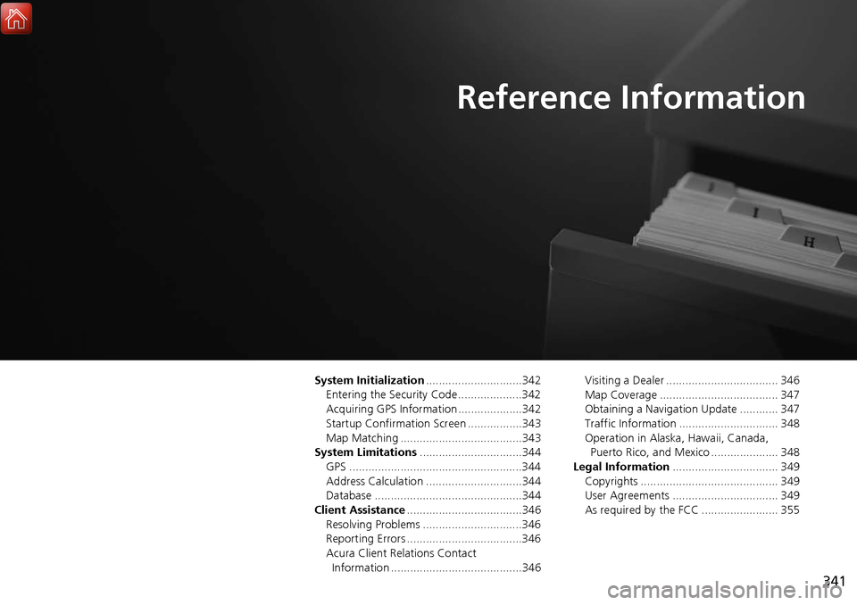
System Initialization..............................342
Entering the Security Code ....................342
Acquiring GPS Information ....................342
Startup Confirmation Screen .................343
Map Matching ......................................343
System Limitations ................................344
GPS ......................................................344
Address Calculation ..............................344
Database ..............................................344
Client Assistance ....................................346
Resolving Problems ...............................346
Reporting Errors ....................................346
Acura Client Relations Contact Information .........................................346 Visiting a Dealer ................................... 346
Map Coverage ..................................... 347
Obtaining a Navigation Update ............ 347
Traffic Information ............................... 348
Operation in Alaska, Hawaii, Canada,
Puerto Rico, and Mexico ..................... 348
Legal Information ................................. 349
Copyrights ........................................... 349
User Agreements ................................. 349
As required by the FCC ........................ 355
Page 343 of 369
342
Reference Information
System Initialization
The navigation system must be initialized if
power to the navigation system is
interrupted for any reason (e.g., the
battery was disconnected).
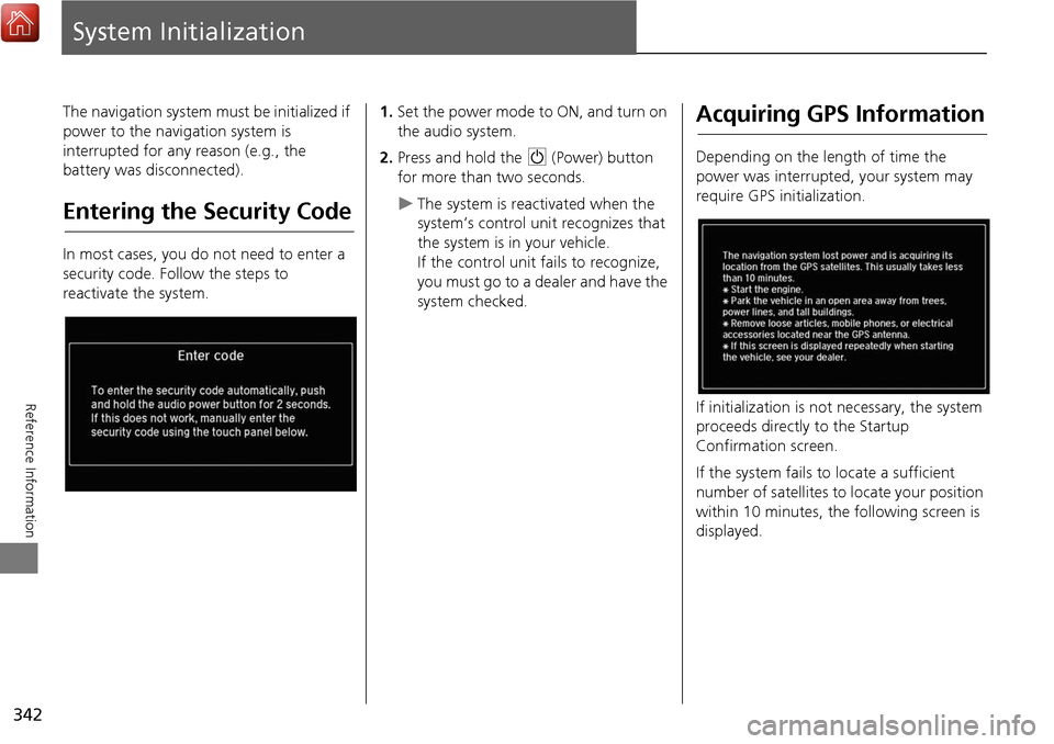
Entering the Security Code
In most cases, you do not need to enter a
security code. Follow the steps to
reactivate the system.
1.Set the power mode to ON, and turn on
the audio system.
2. Press and hold the 9 (Power) button
for more than two seconds.
The system is reac tivated when the
system’s control unit recognizes that
the system is in your vehicle.
If the control unit fails to recognize,
you must go to a dealer and have the
system checked.
Acquiring GPS Information
Depending on the length of time the
power was interrupted, your system may
require GPS initialization.
If initialization is not necessary, the system
proceeds directly to the Startup
Confirmation screen.
If the system fails to locate a sufficient
number of satellites to locate your position
within 10 minutes, the following screen is
displayed.
Page 345 of 369

344
Reference Information
System Limitations
GPS
The signals received from the GPS satellites
are extremely weak (less than a millionth
of the strength of a local FM station) and
require an unobstructed view of the sky.
The GPS antenna is located in the
dashboard. The signal reception can easily
be interrupted or interfered with by the
following:
• Metallic window tint on the front or side
windows
• Cell phones, PDAs, or other electronic
devices docked in a cradle or lying loose
on the dashboard
• Remote starters or “hidden” vehicle
tracking systems mounted near the
navigation unit
• Audio electronic devices mounted near
the navigation unit
• Trees, tall buildings, highway
overpasses, tunnels, or overhead
electrical power wires
The GPS is operated by the U.S.
Department of Defense. For security
reasons, there are certain inaccuracies built
into the GPS for wh ich the navigation
system must constantly compensate. This can cause occasional positioning errors of
up to several hundred feet.
Address Calculation
The destination icon shows only the
approximate location of a destination
address. This occurs if the number of
possible addresses is different from the
number of actual addresses on a block. For
example, the address 1425 on a 1400
block with 100 possible addresses
(because it is followed by the 1500 block)
will be shown a quarter of the way down
the block by the system. If there are only
25 actual addresses
on the block, the
actual location of address 1425 would be
at the end of the block.
Database
The digitized map database reflects
conditions as they existed at various points
in time before production. Accordingly,
your database may contain inaccurate or
incomplete data or information due to the
passage of time, road construction,
changing conditions, or other causes.
For example, some places/landmarks may
be missing when you search the database
because the name was misspelled, the
place was improperly categorized, or a
place/landmark is not yet in the database.
This is also true for police stations,
hospitals, and other public institutions. Do
not rely on the navigation system if you
need law enforcement or hospital services.
Always check with local information
sources.
Page 346 of 369

345
System LimitationsDatabase
Reference Information
In addition, the map database contains
verified and unverified areas. Unverified
streets may be missing from the map, in
the wrong location, or have an incorrect
name or address range. A message will
warn you if your route includes unverified
streets. Exercise additional caution when
driving in unve rified areas.
The database does not include, analyze,
process, consider, or reflect any of the
following categories of information:
• Neighborhood quality or safety
• Population density
• Availability or proximity of law
enforcement
• Emergency, rescue, medical, or other
assistance
• Construction work, zones, or hazards
• Road and lane closures
• Legal restrictions (such as vehicular type,
weight, load, height, and speed
restrictions)
• Road slope or grade
• Bridge height, width, weight, or other
limits
• Traffic facilities safety
• Special events •
Pavement characteristics or conditions
Every effort has been made to verify that
the database is accurate. The number of
inaccuracies you experience increases the
longer you go without obtaining an
updated map database.
2 Obtaining a Navigation Update P. 347
We assume no liability for any incident that
may result from an error in the program, or
from changed conditions not noted above.