2015 MERCEDES-BENZ S-Class tv media
[x] Cancel search: tv mediaPage 98 of 298

X
To select an intermediate destination in the
intermediate destinations menu: turn and
press the controller.
A menu appears.
X To change an intermediate destination:
select Edit
Edit in the menu.
X Change the address, e.g. the city and
street.
X To select OK OK: turn and press the controller.
The intermediate destinations menu
appears and displays the changed inter-
mediate destination.
You can change the sequence of the inter-
mediate destinations entered and the desti-
nation. To change the sequence, at least one
intermediate destination and the destination
must have been entered.
X To change the order: in the menu, select
Move
Move.
X Turn the controller and move the intermedi-
ate destination or destination to the
desired position.
X Press the controller.
X To delete an intermediate destination:
select Delete
Delete in the menu.
Accepting intermediate destinations
for the route X
To select Start Route Guidance Start Route Guidance in the
intermediate destinations menu: press the
controller.
The route is calculated with the entered
intermediate destinations.
If an intermediate destination was passed
during route guidance, the intermediate
destination will be displayed in the inter-
mediate destinations menu with a green
tick mark. Once the route has been recal-
culated, the intermediate destination is
deleted from the intermediate destinations
menu. Searching for a gas station when the
fuel level is low Requirement: the setting
Gas on Reserve Gas on Reserve
must be enabled (Y page 81).
If the fuel tank reserve level is displayed, you
will see the Gas
Gason
onReserve
Reserve Do
Doyou
you want
want
to start a search for surrounding
to start a search for surrounding
gas stations? gas stations? message.
X To select Yes YesorNo
No: turn and press the con-
troller.
If you select Yes Yes, the gas station search
starts. When the search is complete, a list
of the gas stations available along the route or in the vicinity is displayed.
If you select No No, the search is canceled.
X Select the gas station.
The address of the gas station is displayed.
X To select Start
Start: press the controller.
The selected gas station is entered into
position 1 of the intermediate destinations menu. Route guidance begins.
If the intermediate destinations menu
already contains four intermediate desti-
nations, a prompt will be displayed, asking
you whether you wish to enter the gas sta-
tion into position 1. If you select Yes
Yes, the
gas station is transferred into the list and
intermediate destination 4 is deleted. Entering a destination from
Mercedes-Benz Apps
Requirement: mbrace must be activated for
the Mercedes-Benz Apps (Y page 173).
X To switch to navigation mode: press the
00BE button.
X To show the menu: slide6the control-
ler.
X To select Destination Destination: turn and press the
controller.
X Select From Mercedes-Benz Apps
From Mercedes-Benz Apps.
A list shows the available destinations that have been transmitted to the vehicle up to
this point (Y page 181).96
Destination inputNavigation
Page 101 of 298

R
From Last Destinations
From Last Destinations
(Y page 88)
R From Contacts From Contacts (Ypage 89)
Personal route from a tour including
intermediate destinations X
Insert the SD memory card (Y page 215).
X To switch to navigation mode: press the
00CB button.
X Enter a destination, e.g. by address
(Y page 83).
X Start route calculation (Y page 86).
X Create intermediate destinations
(Y page 94).
X To select Save SaveAs
AsPersonal
Personal Route
Routein the
intermediate destinations menu: turn and
press the controller.
The route is saved in the "Personal routes" file on the SD memory card. Importing personal destinations and
routes via Mercedes-Benz Apps
You can use Mercedes-Benz Apps (e. g. Down-
load POI, Local Search) to import destinations
to navigation (Y page 181). These have their
own symbol and are filed in the Mercedes-
Mercedes-
Benz Apps Benz Apps category.
You can save the imported destinations and
routes as personal POIs and routes
(Y page 98).
When importing routes, please note:
R The Mercedes-Benz Apps may generate a
route based on a different map from the
one used by COMAND. Points on the route
may therefore be situated off the digital
roads. For this reason an imported route
commenced in COMAND may deviate from the original route from the Mercedes-Benz
Apps.
R The Mercedes-Benz Apps minimize the
number of route points offered. For this
reason an imported route commenced in COMAND may deviate from the original
route from the Mercedes-Benz Apps. Selecting and editing personal POIs
and routes
Selecting Personal POI
X Insert the SD memory card (Y page 215).
X To switch to navigation mode: press the
00CB button.
X To show the menu: slide6the control-
ler.
X To select Destination Destination: turn and press the
controller.
X Select From Memory Card
From Memory Card.
The menu displays the categories available on the SD memory card.
X To select a category or Personal Routes
Personal Routes:
turn and press the controller.
The available personal POIs or route entries
are displayed.
X Select personal POI or personal route.
The address of the personal POI appears or
the personal route is displayed in the map.
If a large number of entries are stored, a reg-
ister for quick selection appears. Personal
POIs and routes can be saved and sorted with different character sets (e. g. ABC, Cyrillic, Arabic). Personal POIs and routes
99Navigation Z
Page 105 of 298

Displays during route guidance
Change of direction Changes of direction have three phases:
R preparation phase
R announcement phase
R change-of-direction phase
Changes in direction are also shown in the multifunction display (see the vehicle Operator's
Manual).
Preparation phase: COMAND prepares you for the upcoming change of direction. Based on
the example display below, the change of direction is announced by the "Prepare to turn right message", for instance. You see the full-screen map.
Announcement phase: COMAND announces the imminent change of direction. The change
of direction is announced ahead of time, such as with the announcement "Turn right in
200 meters".
The display is now split into two sectors. The map is shown on the left side of the display, and
a detailed image of the intersection or a 3D image of the imminent change of direction is shown on the right side of the display. 0043
Next road
0044 Point at which the change of direction takes place (white dot)
0087 Change of direction (turn right here)
0085 Distance to the next change of direction
Change-of-direction phase: COMAND announces the immediate change of direction. The
change of direction is announced ahead of time, e.g. with the announcement "Now turn right".
The display is split in two like in the announcement phase. Route guidance
103Navigation Z
Page 108 of 298

Once the destination is reached, you will see the checkered flag. Route guidance is finished.
Highway information Requirement: the map content
Highway Information
Highway Informationmust be enabled.
Display mode: while driving on the highway, gas stations, rest stops, rest areas and highway
exits are displayed along with their immediate distances from the current vehicle position. X
To call up the selection mode: while displaying the highway information, slide 9the
controller.
The marker is on the highway information. The associated position is marked on the map.
X To select the desired rest stop/highway exit: turn and press the controller.106
Route guidanceNavigation
Page 112 of 298

X
To switch to navigation mode: press the00BEbutton.
X To show the menu: slide6the controller.
X To select Route
Route: turn and press the controller.
X Select Destination Information
Destination Information.
The destination and existing intermediate destinations are displayed with distances, travel
time and arrival time.
X To select destination or intermediate destination: turn and press the controller.
The address appears.
X Select Save
Save.
The destination or intermediate destination can be saved as:
R a navigable contact in the address book
R My Address
X To call up a map: select Map
Map.
X Move the map, change the map scale and select the destination or the intermediate desti-
nation (Y page 93).
X To call the destination or intermediate destination: select Call
Call.
If a phone is connected and a phone number is available, COMAND switches to the tele-
phone function.
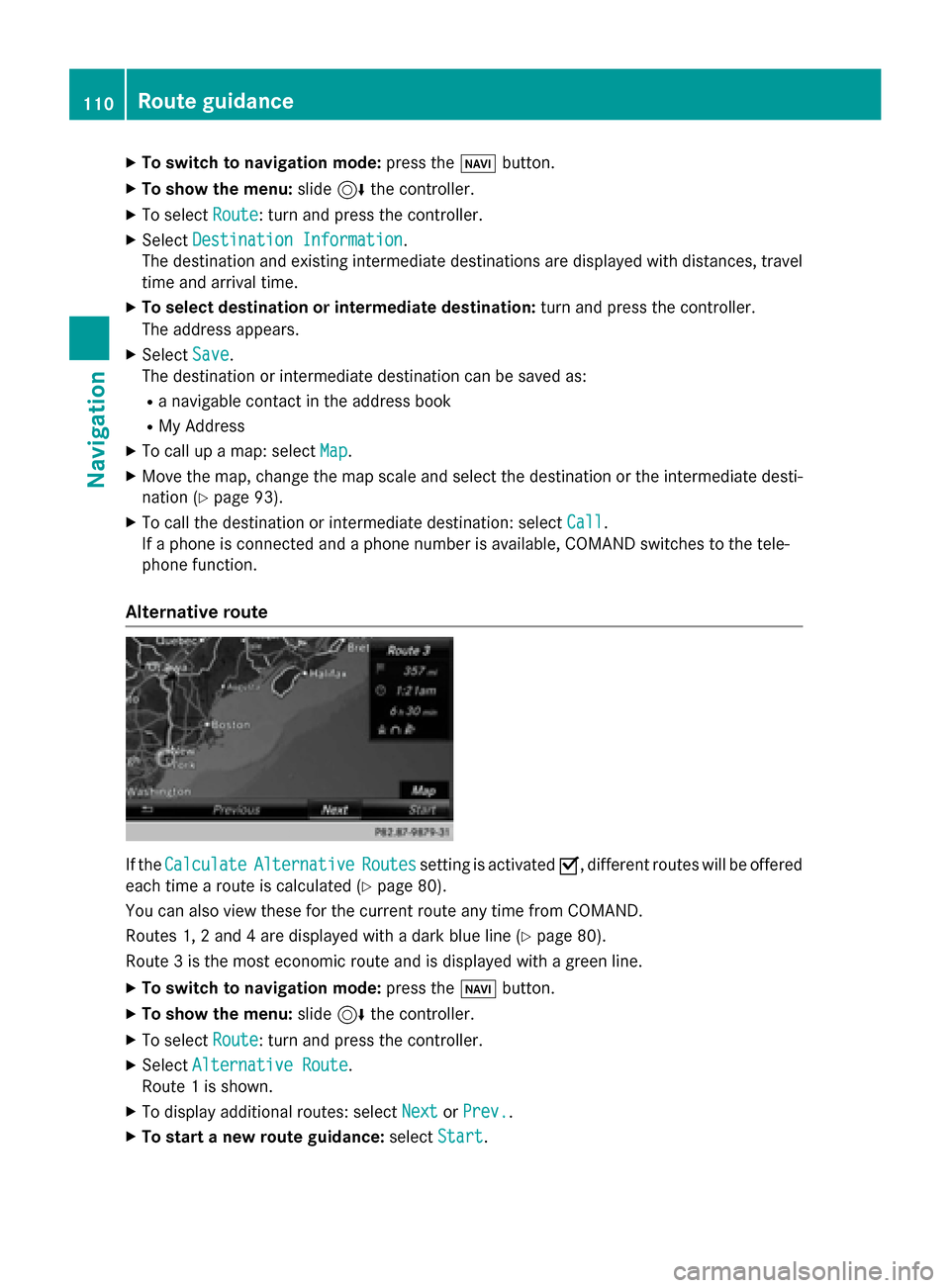
Alternative route If the
Calculate
Calculate Alternative
Alternative Routes
Routessetting is activated 0073, different routes will be offered
each time a route is calculated (Y page 80).
You can also view these for the current route any time from COMAND.
Routes 1, 2 and 4 are displayed with a dark blue line (Y page 80).
Route 3 is the most economic route and is displayed with a green line.
X To switch to navigation mode: press the00BEbutton.
X To show the menu: slide6the controller.
X To select Route
Route: turn and press the controller.
X Select Alternative Route
Alternative Route.
Route 1 is shown.
X To display additional routes: select Next
Next orPrev.
Prev..
X To start a new route guidance: selectStart
Start. 110
Route guidanceNavigation
Page 113 of 298

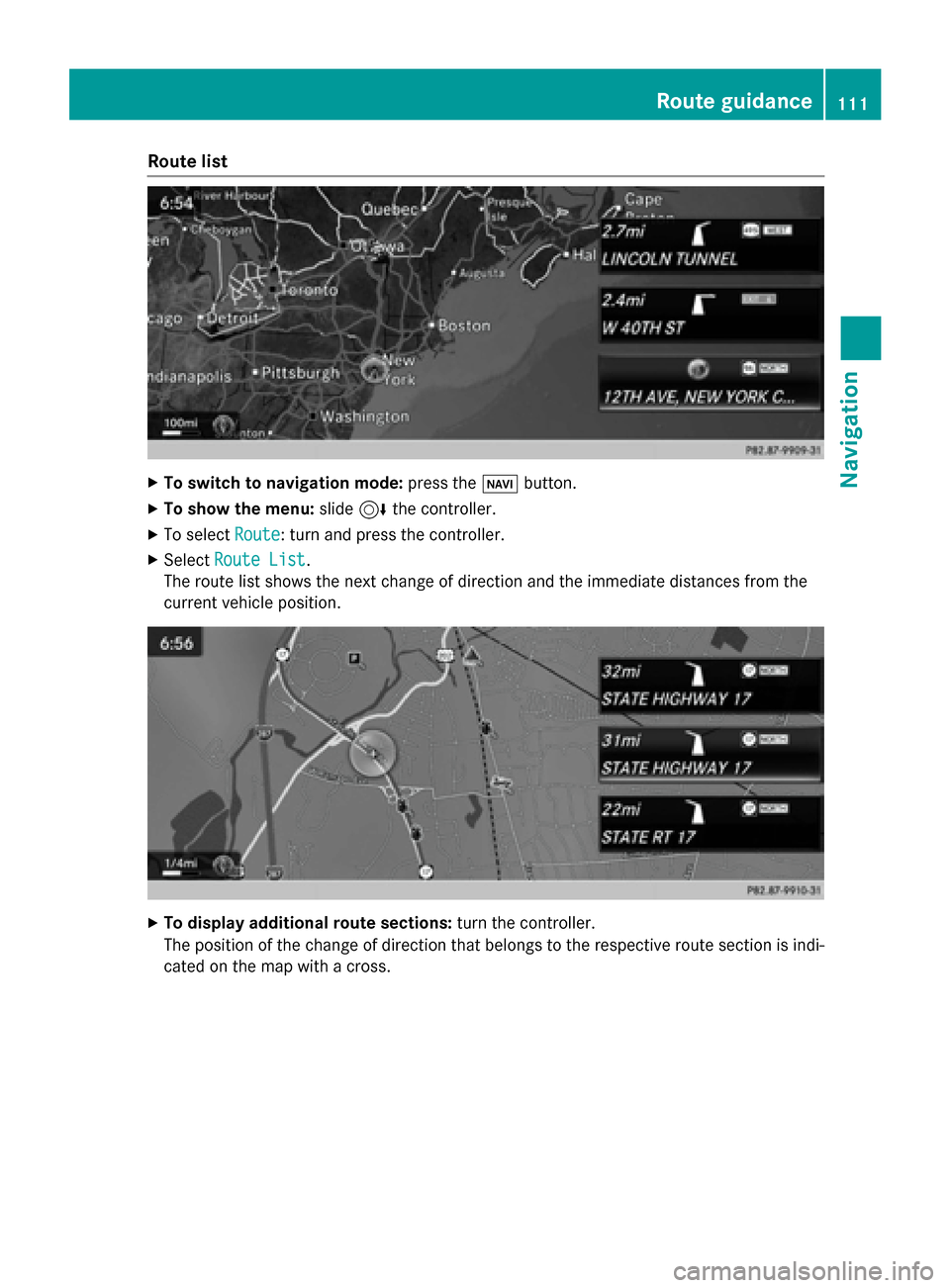
Route list
X
To switch to navigation mode: press the00BEbutton.
X To show the menu: slide6the controller.
X To select Route
Route: turn and press the controller.
X Select Route List
Route List .
The route list shows the next change of direction and the immediate distances from the
current vehicle position. X
To display additional route sections: turn the controller.
The position of the change of direction that belongs to the respective route section is indi- cated on the map with a cross. Route guidance
111Navigation Z
Page 115 of 298

factors such as time of day, time of year and
immediate weather conditions that cannot be judged or taken into consideration by the
COMAND system.
Route guidance to an off-road destina-
tion COMAND can guide you to destinations
which are within the area of the digital map,
but which are not themselves on the map.
These destinations are known as off-road
destinations, which you can enter using the
map, for example. In these cases, COMAND
guides you for as long as possible with navi-
gation announcements and displays on roads
known to the system.
If the vehicle reaches an area which is not part
of the digital map, the display appears as a
split-screen view. On the right, an arrow
appears that points to the off-road destina-
tion. You will hear the announcement: "Please follow the arrow on the display". As the vehi-
cle approaches the destination, you will see a
display to this effect.
Route guidance from an off-road loca-
tion to a destination Off-road location: the vehicle's position is on
the digital map, but the map does not contain
any information about that location.
COMAND is also able to guide you to a des-
tination even from an off-road location.
At the start of route guidance, you will see the
Road Not Mapped
Road Not Mapped message, an arrow and
the distance to the destination. The arrow
shows the compass heading to the actual
destination.
As soon as the vehicle is back on a road
known to the system, route guidance contin- ues in the usual way.
Off-road during route guidance Due to road works, for example, there may be
differences between the data on the digital
map and the actual course of the road. In such cases, the system will temporarily be
unable to locate the vehicle position on the
digital map. The vehicle is therefore in an off- road position.
In the display, you will then see the Road
Road Not Not
Mapped
Mapped message, an arrow and the distance
to the destination. The direction arrow shows
the compass heading to the destination.
As soon as the system can assign the vehicle
position to the map again, route guidance
continues in the usual way. Real-time traffic reports
Prerequisites
i This function is currently not available for
Canada.
In order to receive real-time traffic reports via satellite radio, you need to subscribe to SIR-
IUS XM Satellite Radio Traffic Message
Service.
Further information on satellite radio
(Y page 202).
COMAND can receive traffic reports via sat-
ellite radio and take account of these for
route guidance in the navigation system.
Received traffic reports are displayed on the
map either as text or as symbols. Real-time traffic reports
113Navigation Z
Page 119 of 298

X
To select Traffic
Traffic: turn and press the con-
troller.
X To select Traffic
Traffic Information
Information On
OnMap
Map:
turn and press the controller.
X Select Incidents
Incidents,Speed Speed&
&Flow
Flow orFree
Free
Flow
Flow.
The display is activated 0073or deactivated
0053. Reading out traffic reports on the
route
Introduction The read-aloud function is only available while
route guidance is active. It reads out traffic
reports affecting the current route.
You can select from the following text reader
properties:
R Language (Y page 52)
R Text reader speed (Y page 48)
You can start the text reader function man-
ually or set it to automatic.
Starting the text reader function man-
ually X
To switch to navigation mode: press the
00BE button.
X To show the menu: slide6the control-
ler.
X To select Traffic
Traffic: turn and press the con-
troller.
X Select Read Out All Messages on Read Out All Messages on
Route
Route.
COMAND reads out the reports in
sequence.
If there are no reports for the route, the
Read
Read Out OutAll
AllMessages
Messages on
onRoute
Route menu
item is gray and cannot be selected.
X To cancel the read-aloud function: select
Cancel Read-Aloud Function
Cancel Read-Aloud Function.
COMAND reads out the current report and
then exits the read-aloud function. Automatic read-aloud function X
To switch to navigation mode: press the
00BE button.
X To show the menu: slide6the control-
ler.
X To select Traffic
Traffic: turn and press the con-
troller.
X Select Read Traffic Announcements
Read Traffic Announcements
Automatically
Automatically.
Depending on the previous status, switch
the option on 0073or off 0053. Recalculating the route dynamically
The Dynamic Traffic Route Dynamic Traffic Route route type
takes into account all of the traffic reports it
receives for the current route when calculat-
ing the route (Y page 80).
If you have selected Dynamic Traffic Dynamic Traffic
Route
Route as the route type, COMAND guides you
to your destination along the updated route. Storing destinations
General notes
If a route to a destination has been calculated,
COMAND saves the destination to the last
destinations memory. If the memory is full,
COMAND overwrites the oldest destination.
When you save the current vehicle position or a crosshair position, this position is stored in
the "Last destinations" memory.
You can save destinations permanently in the
address book and on an SD memory card. For instance, this is possible immediately after
entering an address. Storing destinations
117Navigation Z