2015 HONDA ACCORD HYBRID audio
[x] Cancel search: audioPage 4 of 152

3
Quick Reference Guide
Track route (P92)
Follow your route in real-time with voice guidance. FM Traffic (P104)
Bypass congestion an d traffic incidents.
Avoid certain areas (P114)
Set streets and areas to detour around.
Add waypoints (P108)
Add up to
4 “pit stops” along your route.
Voice Control (P20)
Use voice commands to control th e system while driving. You can operate all key functions of the
navigation system.
Audio, Bluetooth ® HandsFreeLink®, and Vehicle Energy
can be operated on this navigation system. See the
Owner’s Manual for information on those systems.
Page 6 of 152

5
Quick Reference GuideVoice Control Operation
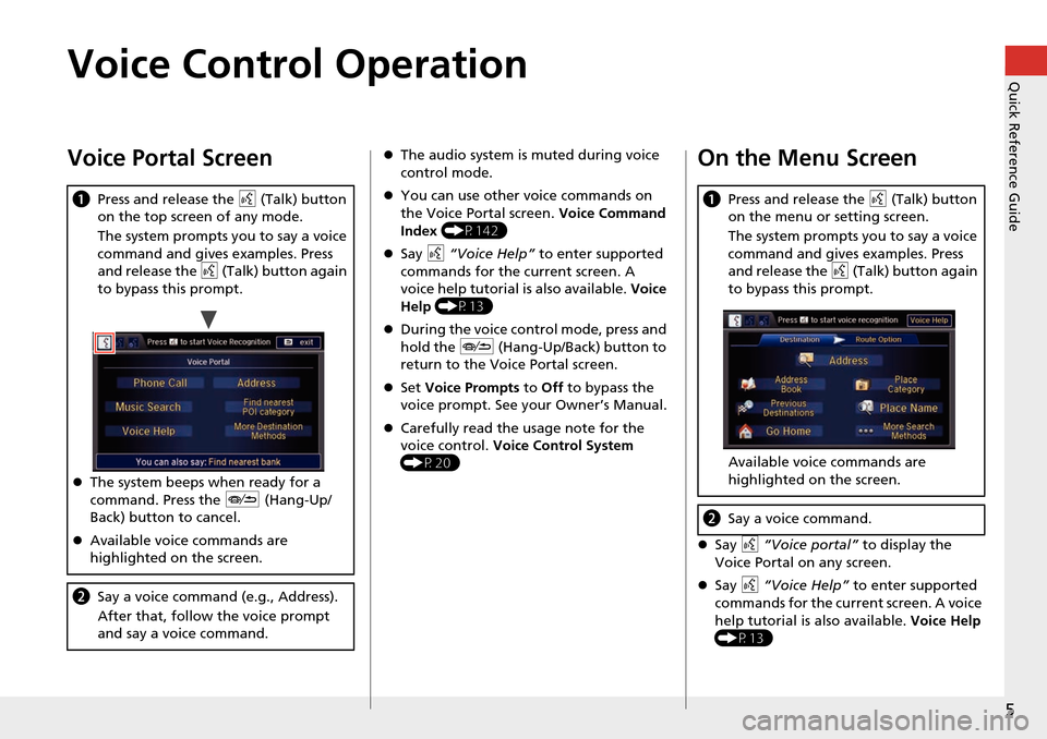
Voice Portal Screen
aPress and release the d (Talk) button
on the top screen of any mode.
The system prompts you to say a voice
command and gives examples. Press
and release the d (Talk) button again
to bypass this prompt.
The system beeps when ready for a
command. Press the J (Hang-Up/
Back) button to cancel.
Available voice commands are
highlighted on the screen.
b Say a voice command (e.g., Address).
After that, follow the voice prompt
and say a voice command.
The audio system is muted during voice
control mode.
You can use other voice commands on
the Voice Portal screen. Voice Command
Index (P142)
Say d “Voice Help” to enter supported
commands for the current screen. A
voice help tutorial is also available. Voice
Help (P13)
During the voice con trol mode, press and
hold the J (Hang-Up/Back) button to
return to the Voice Portal screen.
Set Voice Prompts to Off to bypass the
voice prompt. See your Owner’s Manual.
Carefully read the usage note for the
voice control. Voice Control System
(P20)On the Menu Screen
Say d “Voice portal” to display the
Voice Portal on any screen.
Say d “Voice Help” to enter supported
commands for the current screen. A voice
help tutorial is also available. Voice Help
(P13)
a Press and release the d (Talk) button
on the menu or setting screen.
The system prompts you to say a voice
command and gives examples. Press
and release the d (Talk) button again
to bypass this prompt.
Available voice commands are
highlighted on the screen.
b Say a voice command.
Page 21 of 152

20
System Setup
Voice Control System
Your vehicle has a voice control system that allows hands-free operation of most of
the navigation system functions.
The voice control system uses the d (Talk) and J (Hang-Up/Back) buttons on
the steering wheel and a microphone near the map lights on the ceiling.
A “Getting Started” feature provides a tutorial that explains how to use the voice
control system.
2 Getting Started Tutorial P. 13
Command Input
If the system does not understand a command or you wait too long to give a
command, the system asks y ou to repeat the command.
When you give a command, the system ge nerally either repeats the command as a
confirmation or asks you for further informa tion. If you do not wish to hear this
feedback, you can turn it off. However, list ening to the feedback will help familiarize
you with the way the system ex pects commands to be phrased.
If the system cannot perform a command or the command is not appropriate for the
screen you are on, the system beeps.
On character input screens, a list of possi ble characters is displayed if the system
does not recognize your command.
You can find out which voice commands are available for a particular screen using
the d “Voice Help” command. The system will display and read the list of available
commands to you.
2 Voice Help P. 13
1d (Talk) Button
When you press the d (Talk) button, the system
prompts you to say a voice command and gives
examples. Press and release the d (Talk) button
again to bypass this prompt and give a
command.
1 Command Input
The audio system is muted while using the voice
control system.
Set Voice Prompt to Off if you do not want the
system to provide confirmations and system
prompts. See your Owner’s Manual.
The volume of the Voice Prompt can be
adjusted from the map menu.
2 Adjusting the Voice Prompt Volume P. 100
Page 47 of 152

46
GuidanceNext Maneuver Pop up
System Setup
Next Maneuver Pop up
HSETTINGS button Navi Settings Guidance Next Maneuver Pop up
The navigation system temporarily interrupts the screen display to view the guidance
screen as you approach a guidance point.
Rotate i to select an item. Press u .
The following item s are available:
• LaneWatch : Sets whether to view the guidanc e screen while displaying the
LaneWatch screen.
On (factory default): The guidance scre en interrupts the LaneWatch screen.
Off : Disables the feature.
• Non-map Screens : Sets whether to view the guidance screen while displaying
other mode (e.g., audio, phone, etc.) screen.
On : The guidance screen interrupts other mode screens (except the rear view
mode).
Off (factory default): Disables the feature.
Page 129 of 152

128
Reference Information
System Initialization
The navigation system must be initialized if
power to the navigation system is
interrupted for any reason (e.g., the
battery was disconnected).
Entering the Security Code
Find the navigation system’s security code
and serial number label in your Owner’s
Manual kit. Do not store the label in your
vehicle. If you lose the label, you must first
retrieve the serial number, and then obtain
the code. You can find out about your
serial number and security code from a
dealer.
1. Set the power mode to ON, and turn on
the audio system.
If you set the power mode to
ACCESSORY, you will be requested
to enter the security code. See step 3.
2. Press and hold the PWR 9 (Power)
button for more th an two seconds.
The system is reactivated when the
system’s control unit recognizes that
the system is in your vehicle.
If the control unit fails to recognize,
“ENTER CODE” appears on the
navigation screen.
3. If necessary, enter the security code.
If you do not enter the security code
correctly after 10 tries, leave the
system for one hour before trying
again, or visit a dealer to have the
system reset.
NOTE:
In the U.S. you can register the security
code at Honda Owners
(owners.honda.com.), and find
information on how to retrieve the serial
number and obtain the code at radio-
navicode.honda.com .
Acquiring GPS Information
Depending on the length of time the
power was interrupted, your system may
require GPS initialization.
If initialization is not necessary, the system
proceeds directly to the Startup
Confirmation screen.
If the system fails to locate a sufficient
number of satellites to locate your position
within 10 minutes, the following screen is
displayed.
Page 131 of 152

130
Reference Information
System Limitations
GPS System
The signals received from the GPS satellites
are extremely weak (less than a millionth
of the strength of a local FM station) and
require an unobstructed view of the sky.
The GPS antenna is located in the
dashboard. The signal reception can easily
be interrupted or interfered with by the
following:
• Metallic window tint on the front or side
windows
• Cell phones, PDAs, or other electronic
devices docked in a cradle or lying loose
on the dashboard
• Remote starters or “hidden” vehicle
tracking systems mounted near the
navigation unit
• Audio electronic devices mounted near
the navigation unit
• Trees, tall buildings, freeway overpasses,
tunnels, or overhead electrical power
wires
The GPS is operated by the U.S.
Department of Defense. For security
reasons, there are certain inaccuracies built
into the GPS for wh ich the navigation
system must constantly compensate. This can cause occasional positioning errors of
up to several hundred feet.
Address Calculation
The destination icon shows only the
approximate location of a destination
address. This occurs if the number of
possible addresses is different from the
number of actual addresses on a block. For
example, the address 1425 on a 1400
block with 100 possible addresses
(because it is followed by the 1500 block)
will be shown a quarter of the way down
the block by the system. If there are only
25 actual addresses
on the block, the
actual location of address 1425 would be
at the end of the block.
Database
The digitized map database reflects
conditions as they existed at various points
in time before production. Accordingly,
your database may contain inaccurate or
incomplete data or information due to the
passage of time, road construction,
changing conditions, or other causes.
For example, some places/landmarks may
be missing when you search the database
because the name was misspelled, the
place was improperly categorized, or a
place/landmark is not yet in the database.
This is also true for police stations,
hospitals, and other public institutions. Do
not rely on the navigation system if you
need law enforcement or hospital services.
Always check with local information
sources.
Page 139 of 152

138
Legal InformationUser Agreements
Reference Information
•UPGRADES
If the SOFTWARE is provided by ALPINE
separate from the DEVICE on separate
media or via web download or other
means, and is labeled “For Upgrade
Purposes Only” you may install one (1)
copy of such SOFTWARE onto the
DEVICE as a replacement copy for the
existing SOFTWARE, and use it in
accordance with this EULA, including
any additional EULA terms
accompanying the upgrade SOFTWARE.
• TERMINATION
Without prejudice to any other rights,
ALPINE or MS may terminate this EULA
if you fail to comply with the terms and
conditions of this EULA. In such event,
you must destroy all copies of the
SOFTWARE and all of its component
parts.
• INTELLECTUAL PROPERTY RIGHTS
All title and intellec tual property rights
in and to the SOFTWARE (including but
not limited to any images, photographs,
animations, video, audio, music, text
and “applets,” incorporated into the
SOFTWARE), the accompanying printed
materials, and any copies of the
SOFTWARE, are owned by MS,
Microsoft Corporation, their affiliates or suppliers. The SOFTWARE is licensed,
not sold.
You may not copy the printed materials
accompanying the SOFTWARE. All title
and intellectual prope
rty rights in and to
the content which may be accessed
through use of the SOFTWARE is the
property of the respective content
owner and may be protected by
applicable copyright or other intellectual
property laws and treaties. This EULA
grants you no rights to use such
content. All rights not specifically
granted under this EULA are reserved by
MS, Microsoft Corporation, their
affiliates and suppliers. Use of any on-
line services which may be accessed
through the SOFTWARE may be
governed by the respective terms of use
relating to such services. If this
SOFTWARE contains documentation
that is provided only in electronic form,
you may print one copy of such
electronic documentation.
• TRADEMARKS
This EULA does not grant you any rights
in connection with any trademarks or
service marks of ALPINE MS, Microsoft
Corporation, their affiliates or suppliers. •
PRODUCT SUPPORT
Product support for the SOFTWARE is
not provided by MS, its parent
corporation Microsoft Corporation, or
their affiliates or subsidiaries. For
product support, please refer to ALPINE
support number provided in the
documentation for the DEVICE.
Should you have any questions
concerning this EULA, or if you desire to
contact ALPINE for any other reason,
please refer to the address provided in
the documentation for the DEVICE.
• SOFTWARE TRANSFER ALLOWED BUT
WITH RESTRICTIONS
You may permanently transfer rights
under this EULA only as part of a
permanent sale or transfer of the
Device, and only if the recipient agrees
to this EULA. If the SOFTWARE is an
upgrade, any transfer must also include
all prior versions of the SOFTWARE.
• EXPORT RESTRICTIONS
You acknowledge that SOFTWARE is of
US-origin. You agree to comply with all
applicable international and national
laws that apply to the SOFTWARE,
including the U.S. Ex port Administration
Regulations, as well as end-user, end-
use and country destination restrictions
Page 143 of 152

142
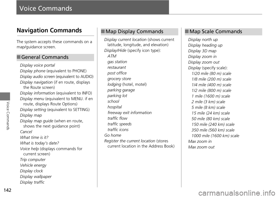
Voice Commands
Voice Commands
Navigation Commands
The system accepts these commands on a
map/guidance screen.Display voice portal
Display phone (equivalent to PHONE)
Display audio screen (equivalent to AUDIO)
Display navigation (if en route, displays
the Route screen)
Display information (equivalent to INFO)
Display menu (equivalent to MENU. if en
route, displays Route Options)
Display setting (equivalent to SETTING)
Display map
Display map guide (when en route,
shows the next guidance point)
Cancel
What time is it?
What is today’s date?
Voice help (displays commands for
current screen)
Trip computer
Vehicle energy
Display clock
Display wallpaper
Display traffic
■ General Commands
Display current location (shows current
latitude, longitude, and elevation)
Display/Hide (specify icon type):
ATM
gas station
restaurant
post office
grocery store
lodging (hotel, motel)
parking garage
parking lot
school
hospital
freeway exit information
traffic flow
traffic speeds
traffic icons
Go home
Register the current location (stores
current location in the Address Book)
■ Map Display Commands
Display north up
Display heading up
Display 3D map
Display zoom in
Display zoom out
Display (specify scale):
1/20 mile (80 m) scale
1/8 mile (200 m) scale
1/4 mile (400 m) scale
1/2 mile (800 m) scale
1 mile (1600 m) scale
2 mile (3 km) scale
5 mile (8 km) scale
15 mile (24 km) scale
50 mile (80 km) scale
150 mile (240 km) scale
350 mile (560 km) scale
1000 mile (1600 km) scale
Max zoom in
Max zoom out
■ Map Scale Commands