2015 Acura MDX sat nav
[x] Cancel search: sat navPage 162 of 341

161
Playing SiriusXM® RadioSiriusXM® Radio Service
Audio
SiriusXM® Radio Service
1.You need your radio ID read y before registering for subscription. To see the ID in
the display: Operate the On Demand Multi-Use DisplayTM until channel 0 appears.
2. Have your radio ID and credit card numb er ready, and either call or visit the
SiriusXM® website to subscribe.
Switch to the SiriusXM® mode by pressi ng the SOURCE button repeatedly or
operating the On Demand Multi-Use Display
TM, and stay in this mode for about 30
minutes until the service is ac tivated. Make sure your vehicle is in an open area with
good reception.
Loading:
SiriusXM® is loading the audio or program information.
Ch off air:
The channel is not currently broadcasting.
Ch unauthorized:
SiriusXM® Radio is receiving information update from the network.
No signal:
The signal is too weak in the current location.
Ch unavailable:
No such channel exists, the channel is not part of your subscription, or the artist or
title information is unavailable.
Check antenna:
There is a problem with the Siri usXM® antenna. Contact a dealer.
1Subscribing to SiriusXM® Radio
Contact Information for SiriusXM® Radio:
SiriusXM® Radio at www.siriusxm.com or (800)
852-9696■ Subscribing to SiriusXM® Radio
■Receiving SiriusXM® Radio
■SiriusXM® Radio Display Messages
1 Receiving SiriusXM® Radio
The SiriusXM® satellites are in orbit over the
equator; therefore, objec ts south of the vehicle
may cause satellite re ception interruptions.
Satellite signals are more likely to be blocked by
tall buildings and mount ains the farther north
you travel from the equator.
You may experience re ception problems under
the following circumstances:
• In a location with an obstruction to the south
of your vehicle.
• In tunnels
• On the lower level of a multi-tiered road
• Large items carrie d on the roof rack
Page 297 of 341

296
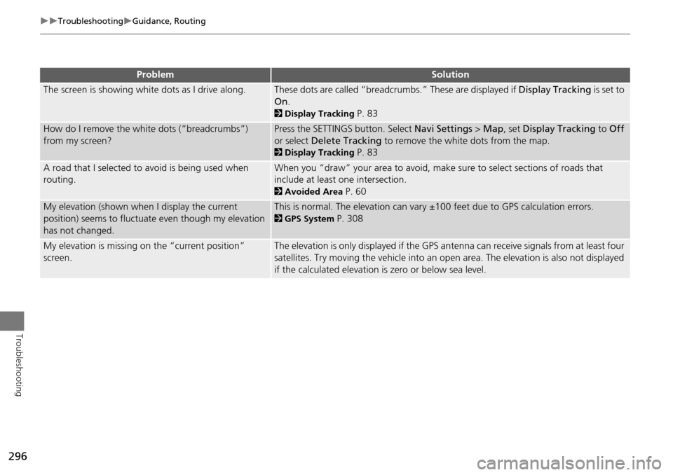
TroubleshootingGuidance, Routing
Troubleshooting
The screen is showing white dots as I drive along.These dots are called “breadcrumbs.” These are displayed if Display Tracking is set to
On .
2Display Tracking P. 83
How do I remove the white dots (“breadcrumbs”)
from my screen?Press the SETTINGS button. Select Navi Settings > Map , set Display Tracking to Off
or select Delete Tracking to remove the white dots from the map.
2Display Tracking P. 83
A road that I selected to avoid is being used when
routing.When you “draw” your area to avoid, make sure to select sections of roads that
include at least one intersection.
2Avoided Area P. 60
My elevation (shown when I display the current
position) seems to fluctuate even though my elevation
has not changed.This is normal. The elevation can vary ±100 feet due to GPS calculation errors.
2GPS System P. 308
My elevation is missing on the “current position”
screen.The elevation is only displayed if the GPS antenna can receive signals from at least four
satellites. Try moving the vehicle into an open area. The elevation is also not displayed
if the calculated elevation is zero or below sea level.
ProblemSolution
Page 307 of 341

306
Reference Information
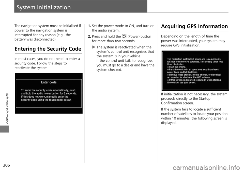
System Initialization
The navigation system must be initialized if
power to the navigation system is
interrupted for any reason (e.g., the
battery was disconnected).
Entering the Security Code
In most cases, you do not need to enter a
security code. Follow the steps to
reactivate the system.
1.Set the power mode to ON, and turn on
the audio system.
2. Press and hold the 9 (Power) button
for more than two seconds.
The system is reac tivated when the
system’s control unit recognizes that
the system is in your vehicle.
If the control unit fails to recognize,
you must go to a dealer and have the
system checked.
Acquiring GPS Information
Depending on the length of time the
power was interrupted, your system may
require GPS initialization.
If initialization is not necessary, the system
proceeds directly to the Startup
Confirmation screen.
If the system fails to locate a sufficient
number of satellites to locate your position
within 10 minutes, the following screen is
displayed.
Page 309 of 341

308
Reference Information
System Limitations
GPS System
The signals received from the GPS satellites
are extremely weak (less than a millionth
of the strength of a local FM station) and
require an unobstructed view of the sky.
The GPS antenna is located in the
dashboard. The signal reception can easily
be interrupted or interfered with by the
following:
• Metallic window tint on the front or side
windows
• Cell phones, PDAs, or other electronic
devices docked in a cradle or lying loose
on the dashboard
• Remote starters or “hidden” vehicle
tracking systems mounted near the
navigation unit
• Audio electronic devices mounted near
the navigation unit
• Trees, tall buildings, freeway overpasses,
tunnels, or overhead electrical power
wires
The GPS is operated by the U.S.
Department of Defense. For security
reasons, there are certain inaccuracies built
into the GPS for wh ich the navigation
system must constantly compensate. This can cause occasional positioning errors of
up to several hundred feet.
Address Calculation
The destination icon shows only the
approximate location of a destination
address. This occurs if the number of
possible addresses is different from the
number of actual addresses on a block. For
example, the address 1425 on a 1400
block with 100 possible addresses
(because it is followed by the 1500 block)
will be shown a quarter of the way down
the block by the system. If there are only
25 actual addresses
on the block, the
actual location of address 1425 would be
at the end of the block.
Database
The digitized map database reflects
conditions as they existed at various points
in time before production. Accordingly,
your database may contain inaccurate or
incomplete data or information due to the
passage of time, road construction,
changing conditions, or other causes.
For example, some places/landmarks may
be missing when you search the database
because the name was misspelled, the
place was improperly categorized, or a
place/landmark is not yet in the database.
This is also true for police stations,
hospitals, and other public institutions. Do
not rely on the navigation system if you
need law enforcement or hospital services.
Always check with local information
sources.
Page 314 of 341

313
Reference Information
Legal Information
Copyrights
•Infogroup-Data: Certain business data
provided by Infogroup © 2011, All
RIghts Reserved.
• EXIT-Data: © ZENRIN CO., LTD. 2011.
All rights reserved.
• Building foot print: © ZENRIN CO., LTD.
2011. All rights reserved.
• Junction View Data: © ZENRIN USA,
INC. 2011. All rights reserved.
• Brand icon: The marks of companies
displayed by this product to indicate
business locations are the marks of their
respective owners. The use of such
marks in this product does not imply any
sponsorship, approval, or endorsement
by such companies of this product.
User Agreements
In using this HDD “Satellite Linked
Navigation System” (the “HDD”), which
includes HONDA MOTOR CO., LTD.
software, ALPINE ELECTRONICS, INC.
software, and NAVTEQ database contents
(hereinafter referred to as “Licensors”),
you are bound by the terms and conditions
set forth below. By using your copy of the
HDD, you have expre ssed your Agreement
to the terms and conditions of this
Agreement. You should, therefore, make
sure that you read and understand the
following provisions. If for any reason you
do not wish to be bound by the terms of
this Agreement, please return the HDD to
your dealer.
• The HDD may not be copied, duplicated,
or otherwise modified, in whole or in
part, without the express written
permission of the Licensors.
• The HDD may not be transferred or
sublicensed to any third party for profit,
rent or loan, or lice nsed for reuse in any
manner.
■ Navigation System User
Agreement
• The HDD may not be decompiled,
reverse engineered or otherwise
disassembled, in whole or in part.
• The HDD may not be used in a network
or by any other manner of simultaneous
use in multiple systems.
• The HDD is intended solely for personal
use (or internal use where the end-user
is a business) by the consumer. The HDD
is not to be used for commercial
purposes.
• The Licensors do not guarantee to the
client that the functi ons included in the
HDD meet the specific objectives of the
user.
• Licensor shall not be responsible for any
damages caused by the use of the HDD
to the actual user or to any third party.
• The warranty on the HDD shall not
extend to an exchange or refund due to
misspelling, omission of letters, or any
other cosmetic discrepancy in the
contents of the HDD.
• The right to use the HDD shall expire
either when the user destroys the HDD
or software, or when any of the terms
of this Agreement are violated and the
Licensors exercise the option to revoke
the license to use the HDD or software.
Continued
Page 315 of 341

314
Legal InformationUser Agreements
Reference Information
•The terms and conditions hereof apply
to all subsequent users and owners as
well as to the original purchaser.
• The logos of oil companies, hotels,
convenience stores, and other
businesses are displayed for your
information and convenience, and in no
way imply any sponsorship, approval or
endorsement of these companies, or
their products. The logos are trademarks
of their respective owners.
• The marks of companies displayed by
this product to indicate business
locations are the marks of their
respective owners.
• The use of such marks in this product
does not imply any sponsorship,
approval, or endo rsement by such
companies of this product.
The user shall indemnify and save harmless
the Licensors, and their officers, employees
and agents, from and against any claim,
demand or action, irrespective of the
nature of the cause of the claim, demand
or action, alleging loss, costs, expense,
damages or injuries (including injuries
resulting in death) arising out of the use or
possession of the HDD or software. Use, duplication, or
disclosure of this HDD
by or on behalf of the United States
government is subject to “Restricted
Rights” as set forth at FAR 52.227-14, -19
or DFARS 252.227-7013, as applicable.
Manufacturers are the Licensors, including
HONDA MOTOR CO., LT D., 2-1-1 Minami
Aoyama Minato-Ku Tokyo 107-8556
JAPAN., Alpine Electronics, Inc., 20-1
Yoshima Kogyodanchi, Iwaki, Fukushima
970-1192 JAPAN., NAVTEQ Corporation,
425 W Randolph St. Chicago, IL 60606,
USA.
You have acquired a device (“DEVICE”)
that includes software licensed by Alpine
Electronics, Inc. (collectively “ALPINE”)
from an affiliate of Microsoft Corporation
(collectively “MS”). Those installed
software products of MS origin, as well as
associated media, printed materials, and
“online” or electronic documentation
(“SOFTWARE”) are protected by
international intellectual property laws and
treaties. The SOFTWARE is licensed, not
sold. All righ ts reserved.
■Navigation System END USER
LICENSE AGREEMENT
IF YOU DO NOT AGREE TO THIS END USER
LICENSE AGREEMENT (“EULA”), DO NOT
USE THE DEVICE OR COPY THE SOFTWARE
INSTEAD, PROMPTLY CONTACT ALPINE
FOR INSTRUCTIONS ON RETURN OF THE
UNUSED DEVICE(S) FOR A REFUND. ANY
USE OF THE SOFTWARE, INCLUDING BUT
NOT LIMITED TO USE ON THE DEVICE,
WILL CONSTITUTE YOUR AGREEMENT TO
THIS EULA (OR RATIFICATION OF ANY
PREVIOUS CONSENT).
• GRANT OF SOFTWARE LICENSE
This EULA grants you the following
license: You may use the SOFTWARE
only on the DEVICE.
• NOT FAULT TOLERANT
THE SOFTWARE IS NOT FAULT
TOLERANT. ALPINE HAS
INDEPENDENTLY DETERMINED HOW TO
USE THE SOFTWARE IN THE DEVICE,
AND MS HAS RELIED UPON ALPINE TO
CONDUCT SUFFICIENT TESTING TO
DETERMINE THAT THE SOFTWARE IS
SUITABLE FOR SUCH USE.
• NO WARRANTIES FOR THE SOFTWARE
THE SOFTWARE is provided “AS IS” and
with all faults. THE ENTIRE RISK AS TO
SATISFACTORY QUALITY,
PERFORMANCE, ACCURACY, AND