2014 SKODA YETI infotainment
[x] Cancel search: infotainmentPage 60 of 88

Navigation
Description of the navigation system
Preface to navigation
Introduction
This chapter contains information on the following subjects:
Navigation data
57
Main menu
58
Map display
58
Map Orientation
59
Map scale
59
Options for map display
60
Split screen
60
First and foremost, pay attention to the safety instructions » page 7 , Impor-
tant notes .
The unit uses the GPS (Global Positioning System) satellite system for route
guidance. The satellite signal allows you to determine your current vehicle po-
sition.
Outside the range of the GPS satellite signal (e.g. in dense vegetation, in tun-
nels, parking garages, etc.), the unit navigates only with restrictions using on-
vehicle sensors.
The route guidance is as follows.
› With graphical driving recommendations in the device screen and MAXI DOT
display.
› With navigation announcements.
WARNING■
Information about traffic lights, stop and right of way signs, parking and
stopping restrictions as well as lane constrictions and speed restrictions is
not taken into account for route guidance by the unit.■
The navigation announcements provided may vary from the actual situa-
tions, e.g. due out-of-date navigation data.
■
The volume should be adjusted to ensure that acoustic signals from out-
side, e.g. sirens from vehicles which have the right of way, such as police,
ambulance and fire brigade vehicles, can be heard at all time.
CAUTIONIn some countries, some unit features can no longer be selected when the ve-
hicle is running faster than a certain speed. This is not a malfunction, but com-
plies with the national legal regulations.
Navigation data
Read and observe
and on page 57 first.
Navigation data source
You received the SD memory card with navigation data together with the unit.
For correct functioning of the device, the card must be inserted into slots
12
or
13
» Fig. 1 on page 7 during the entire route guidance.
Insert the memory card » page 33, SD memory card .
Data update
The navigation data is subject to constant changes (such as new streets,
changes of street names and house numbers) and are no longer valid after
some time. Therefore the route guidance may be inaccurate of incorrect. We
recommend that you update the navigation data on a regular basis.
For more information on updating the data, please visit the ŠKODA website
www.infotainment.skoda-auto.com or contact a ŠKODA Partner.
The version of the navigation data for maps can be found in the navigation
settings
→
→ Version information .
Card has been damaged or lost
If the SD memory card with the navigation data has been damaged or lost, a
new card can be obtained from ŠKODA original accessories. The navigation da-
ta can be loaded only on the original card.
57Description of the navigation system
Page 70 of 88

Home address
The menu provides a quick destination guide to a stored home address.›
Press in the menu Navigation function key
Destinations → Home address .
The route calculation and the route guidance is started or after the route cal-
culation the route type can be selected then the route guidance starts.
If the home address has not been entered, a message with the following menu
is displayed.
Please select as your home address: your current position or a new address.
› Position
- Entry of the home address through taking the current position of
the vehicle;
› Address
- Enter the home address in writing.
The position of the “Home address”is displayed in the map by the symbol -
D
» Fig. 32 on page 58 .
The home address is also available in the menu Navigation, by pressing the
symbol key
→ Manage memory → Define home address .
Custom destination (vCard)
Custom destinations can be loaded onto the device from an SD memory card or
a USB flash drive in vCard format.
›
Press in the menu Navigation function key
→ Import destinations .
A list of possible data import sources is displayed.
After selecting the source and confirming the menu item Import all vCards
from this folder the importing the data stored in vCard format into the device
memory begins.
For more information on creating and importing your custom destination see
the ŠKODA Web pages www.infotainment.skoda-auto.com .
Image with GPS coordinates
If an image contains the GPS coordinates, viewing causes the function key
» Fig. 21 on page 36 to be shown.
›
Press the function key
and the destination details opens
» page 75.
POI
Introduction
This chapter contains information on the following subjects:
Entering a new POI
67
Search area for POI
68
Search and selecting a POI
68
Quick search and selecting a POI
68
Personal POI
68
First and foremost, pay attention to the safety instructions » page 7 , Impor-
tant notes .
This chapter covers the search and entry options of a POI.
Entering a new POI
Fig. 39
POI entry
›
Press in the menu Navigation function key
→ New dest. → Options
→
POI - the following menu appears.
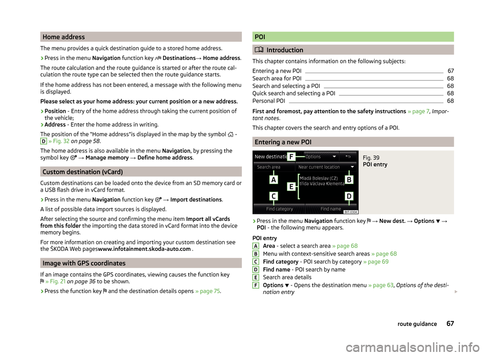
POI entry Area - select a search area » page 68
Menu with context-sensitive search areas » page 68
Find category - POI search by category » page 69
Find name - POI search by name
Search area details
Options
- Opens the destination menu
» page 63, Options of the desti-
nation entry
ABCDEF67route guidance
Page 71 of 88

More options for calling the menu
› Press in the menu
Navigation function key Route → New dest. / stopover
→ Options
→ POI .
› Press in the menu
Navigation function key
Other POIs .
Search area for POI
Fig. 40
Search area for POIs
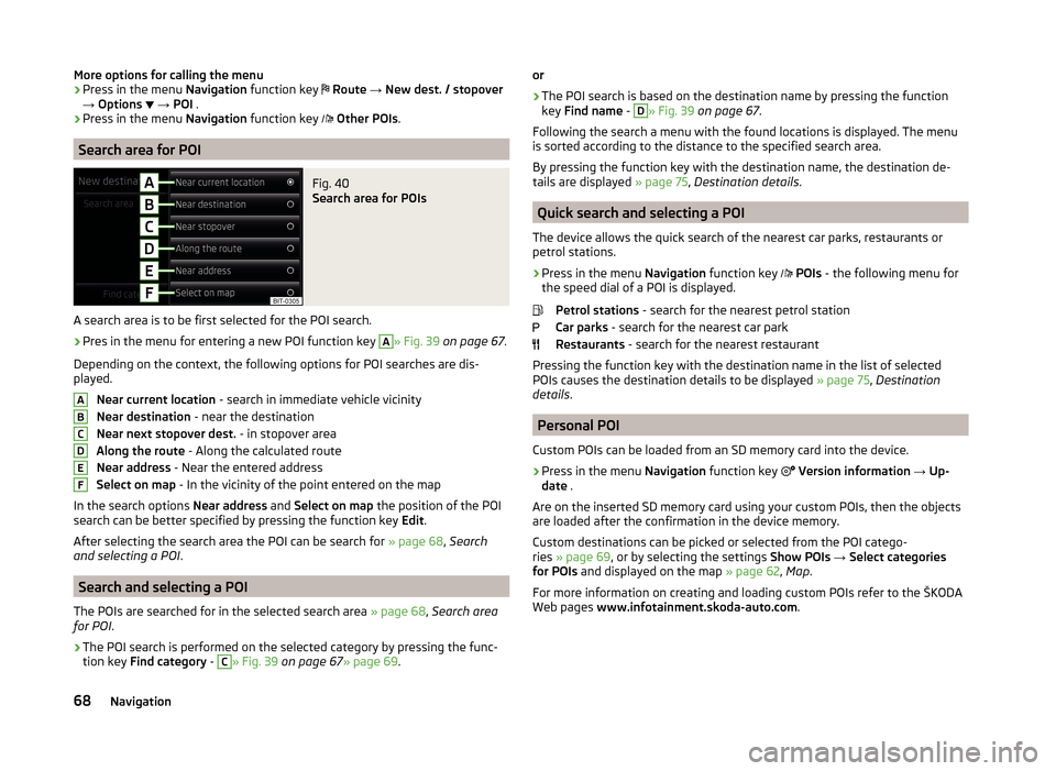
A search area is to be first selected for the POI search.
›
Pres in the menu for entering a new POI function key
A
» Fig. 39 on page 67 .
Depending on the context, the following options for POI searches are dis-
played.
Near current location - search in immediate vehicle vicinity
Near destination - near the destination
Near next stopover dest. - in stopover area
Along the route - Along the calculated route
Near address - Near the entered address
Select on map - In the vicinity of the point entered on the map
In the search options Near address and Select on map the position of the POI
search can be better specified by pressing the function key Edit.
After selecting the search area the POI can be search for » page 68, Search
and selecting a POI .
Search and selecting a POI
The POIs are searched for in the selected search area » page 68, Search area
for POI .
›
The POI search is performed on the selected category by pressing the func-
tion key Find category -
C
» Fig. 39 on page 67 » page 69.
ABCDEFor›
The POI search is based on the destination name by pressing the function
key Find name -
D
» Fig. 39 on page 67 .
Following the search a menu with the found locations is displayed. The menu
is sorted according to the distance to the specified search area.
By pressing the function key with the destination name, the destination de-
tails are displayed » page 75, Destination details .
Quick search and selecting a POI
The device allows the quick search of the nearest car parks, restaurants or
petrol stations.
›
Press in the menu Navigation function key
POIs - the following menu for
the speed dial of a POI is displayed.
Petrol stations - search for the nearest petrol station
Car parks - search for the nearest car park
Restaurants - search for the nearest restaurant
Pressing the function key with the destination name in the list of selected
POIs causes the destination details to be displayed » page 75, Destination
details .
Personal POI
Custom POIs can be loaded from an SD memory card into the device.
›
Press in the menu Navigation function key
Version information → Up-
date .
Are on the inserted SD memory card using your custom POIs, then the objects
are loaded after the confirmation in the device memory.
Custom destinations can be picked or selected from the POI catego-
ries » page 69 , or by selecting the settings Show POIs → Select categories
for POIs and displayed on the map » page 62, Map .
For more information on creating and loading custom POIs refer to the ŠKODA
Web pages www.infotainment.skoda-auto.com .
68Navigation
Page 88 of 88

www.skoda-auto.com
Amundsen: Yeti
Infotainment anglicky 11.2014
S90.5614.02.20
5L0012720DA
5L0012720DA