2014 MITSUBISHI OUTLANDER change time
[x] Cancel search: change timePage 5 of 226
5
IntroductionBefore UseIntroduction
The followings are what you need to know before using this product.
Before Use
Disclaimers
• Mitsubishi Motors will in no way be held
responsible for losses resulting from fire,
earthquake, tsunami, flood, or other natural
disasters; from actions of third parties; from
other accidents; or from inappropriate or
abnormal usage conditions utilized by the
customer, be said conditions deliberate or
unintentional.
• There will be no indemnification for alteration
or loss of any information stored upon
this product (address book etc.) by the
customer or a third party resulting from
improper use of this product, the influence
of static electricity or electric noise, or at
the time of malfunction or repair or similar
circumstances. We recommend that you
create backups of important information as a
precautionary measure.
• Some personal information (addresses in
address book, telephone numbers etc.) input
into this product may remain in memory even
if this product is removed. The customer
is responsible for proper handling and
management (including deleting) of personal
information to protect privacy when handing
this product over to anyone else or disposing
of it. Mitsubishi Motors will in no way be held
responsible. •
Mitsubishi Motors will in no way be held
responsible for any collateral losses (loss
of business profits, alteration or loss of
recorded data) resulting from the usage or
inability to use this product.
• Please be aware that the map displayed
is from when the data was prepared, so it
may differ from current conditions. Also,
Mitsubishi Motors will in no way be held
responsible for any losses resulting from
map data inadequacies.
• This product contains data on traffic
regulations, but due to changes in traffic
rules, this data may differ from the actual
traffic rules. Always obey the actual traffic
regulations. Also, Mitsubishi Motors will in
no way be held responsible for any losses
resulting from traffic accidents or traffic
rule violations due to traffic regulation data
inadequacies.
• Returns, refunds, exchange, or conversion
for reasons of map data inadequacy or the
like are not possible. There may be times
when the map data does not match the
specific objective of the user. The contents of
the map data are subject to change without
notice. The map data may contain wrong or
missing characters, incorrect locations etc. •
The rule guidance and audio guidance,
for example when to turn, may sometimes
differ from the actual traffic signs or traffic
regulations. Always obey the actual traffic
signs and actual traffic regulations.
• For the purpose of product improvement,
specifications and external appearance may
be subject to change without advance notice.
Accordingly, while the contents of the User
Manual may differ, please be aware that
returns, refunds, exchange, or conversion
are not possible.
• This User Manual explains details for
multiple vehicle models together. Depending
on the vehicle model, there may be functions
that may be described but not available,
or requirements for separately purchased-
products. Thank you for your understanding.
• Images and illustrations used in the
User Manual are either those used in
development, or used for explanations.
Please be aware that these may differ from
the actual images and illustrations used in
the product.
• Please be aware that Mitsubishi Motors,
including after-sales service departments,
will in no way be held responsible for any
losses or detriment resulting from alteration
or loss of any information stored in this
product, including customer registration
information.
Page 6 of 226
6
Important Points on Usage
Common
• During operation, ensure that the vehicle is
not stationary in a garage or other confined
area with bad ventilation while the engine
is running. Doing so may result in gas
poisoning.
• For safety, the driver is not to operate this
product while the vehicle is moving. The
driver should also minimize as much as
possible the time spent viewing the screen.
Being distracted by the screen can result in
an accident.
• Do not turn the volume up to the extent that
you cannot hear sounds from outside the
vehicle while driving. Driving without being
able to hear sounds from outside the vehicle
can result in an accident.
• Do not disassemble or modify the product.
This may lead to malfunction, smoking, or
fire.
• Avoid relying on this product for guidance
to emergency facilities (hospitals, fire
departments, police, etc.). Contact such
emergency facilities directly.
• When operating, ensure that the vehicle is
stopped in a safe area in which stopping is
permitted.
• Continued usage of this product without
the engine running may deplete the vehicle
battery, meaning that the engine may not be
able to start.
Ensure this product is used while the engine
is running. •
The following phenomena are characteristic
of LCD screens. They do not indicate a
malfunction.
- Small black dots or bright dots (red, blue,
green) on the screen.
- Screen movement is slow during cold
weather.
- The screen is sometimes dark during hot
weather.
- The color tones and brightness vary with
the viewing angle.
• It is a characteristic of LCD screens that the
picture quality varies with the viewing angle.
When using this product for the first time,
adjust the picture quality.
• If you paste an commercially-available LCD
protective film or the like on the screen, it
may interfere with touch panel operation.
• If you operate the touch panel with a sharp
object (pen tip, finger nail, etc.), the screen
may be scratched and this unit may be
damaged, leading to faulty operation.
• Operating the touch panel with gloves on
may cause faulty operation.
• When cleaning the screen, wipe it with a soft
cloth. Do not use benzene, paint thinners,
anti-static agents, or other chemical wipes.
They could scratch the screen.
iPod/iPhone Playback
Function (Option)
• This product supports audio playback from
iPod/iPhone devices, however differing
versions mean that playback cannot be
guaranteed.
• Please be aware that depending on the
iPod/iPhone model or version, operation
may differ.
FCC NOTE
This device complies with part 15 of the FCC
Rules.
Operation is subject to the following two
conditions : (1) This device may not cause
harmful interference, and (2) this device must
accept any interference received, including
interference that may cause undesired
operation.
FCC CAUTION
Changes or modifications not expressly
approved by the party responsible for
compliance could void the user’s authority to
operate the equipment.
Page 28 of 226
28 Navigation Functions
Route Search Methods
• The route displayed in the route guidance
is a reference route to the destination. It
is not necessarily the shortest route. This
route guidance also does not take traffic
congestion information into account.
• Not all roads are used in route guidance.
• Routes using ferries are set to be less
recommended than normal roads. Therefore,
even when a ferry provides a quicker route
to the destination, a route not using the ferry
may be displayed.
• When a toll road interchange, parking area,
or service area is set as the destination or
as a waypoint, select from an establishment
search or from a freeway simplified map and
set without scrolling the map.
• Sometimes, the route is not the same as the
one prepared previously even though the
same locations were set as the destination
and waypoints.
• Sometimes routes are displayed that include
pedestrian ways, stairs, etc. that are not
passable by vehicle.
• If there is no road to the destination or only
narrow roads, a route may be displayed
that goes to some place apart from the
destination.
• Because searches are carried out passing
alongside establishments, depending on the
road configuration, roundabout routes may
be displayed.
• Sometimes routes are searched that take
traffic rule information into account.
• Sometimes, some temporary rules are not
taken into account or the time for which
they are applied differs from when they are
actually in effect.
Route Guidance
• When your car is driving on the searched
route, this displays the distance until the
destination or the next waypoint.
• When your car is driving off the searched
route, this displays the distance from the
point where you left the route until the
destination or the next waypoint.
• The display of the estimated time of arrival
at the destination is calculated based on the
remaining time data in the map data and
learning trip information.
• Sometimes even though you need to turn
at a junction, the junction name is not in the
guidance and the junction is not covered in
the audio guidance.
• Sometimes left and right turn guidance
differs from the actual road configuration.
• When you go off the route, for example by
turning one junction too early, sometimes the
audio guidance continues for the route you
had been on.
• Sometimes the distance in the guidance is
slightly too high or too low.
Precautions for operating the
navigation
• During route guidance, always obey the
actual traffic regulations. Failure to do so
may cause a traffic accident.
• The route is searched using the map data on
the map card. Sometimes it may differ from
actual restrictions for construction, one-way
rules, and other traffic rules. Always obey
the actual traffic regulations.
• Traffic rules that depend on the time of
day reflect the time at which the route was
searched. When driving the route, always
obey the actual traffic regulations.
• The distance your car has traveled is
measured with the speed sensor (and this
speed is proportional to the rotation rate of
the tires).When the tires are new, if you have
non-standard tires, or if the tire air pressure
is not correct, error inputs the distance
measurement more easily and the location
of your car may not be displayed correctly.
• The route is a reference route to around the
destination. It is not the shortest route or the
route most free of traffic congestion.
• While you are driving, the amount of road
information displayed is restricted and some
roads may not be displayed.(For example,
narrow streets)
• If the distance to the destination is extremely
short or extremely long, route search may be
impossible.
• Even if you travel off the route, the route is
automatically recalculated.
• The estimated time of arrival varies with the
road conditions and how you drive.
Page 29 of 226
Navigation Screen 29
NAVIBasic Operation
Navigation Screen
This section explains the navigation map screen and the display contents\
for the menu
screens.
Map Display Contents
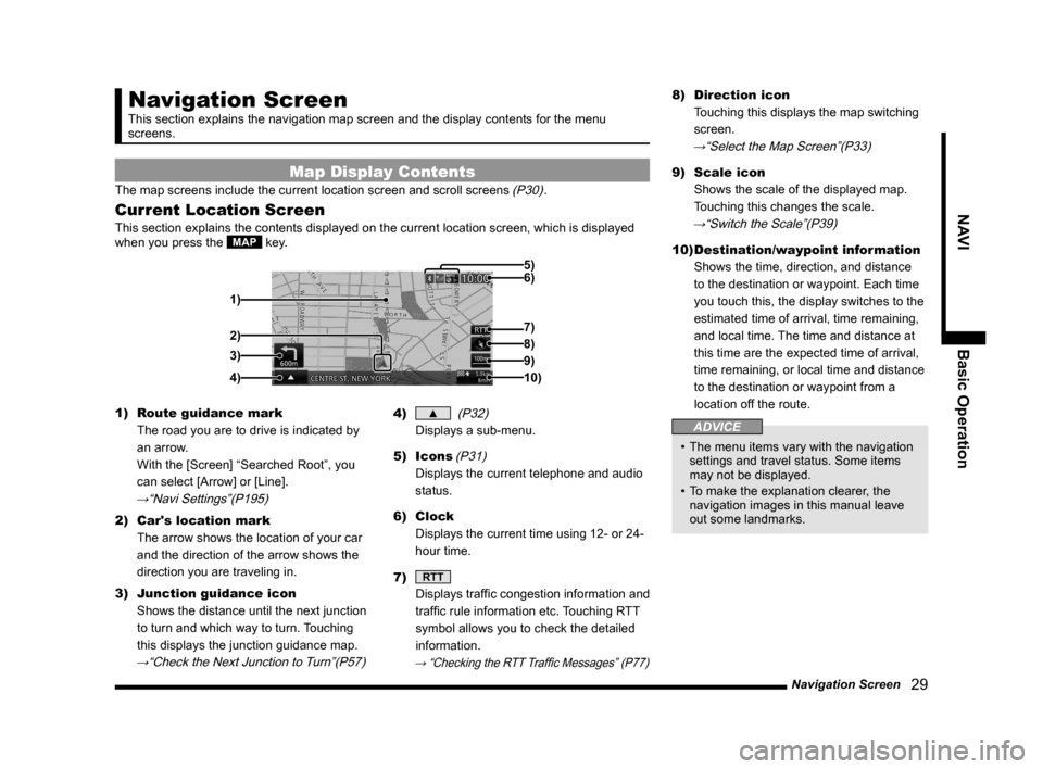
The map screens include the current location screen and scroll screens (P30).
Current Location Screen
This section explains the contents displayed on the current location scr\
een, which is displayed
when you press the MAP key.
3)
4) 1) 6) 5)
8)
7)
2)
9)
10)
1) Route guidance mark
The road you are to drive is indicated by
an arrow.
With the [Screen] “Searched Root”, you
can select [Arrow] or [Line].
→“Navi Settings”(P195)
2) Car's location mark
The arrow shows the location of your car
and the direction of the arrow shows the
direction you are traveling in.
3) Junction guidance icon
Shows the distance until the next junction
to turn and which way to turn. Touching
this displays the junction guidance map.
→“Check the Next Junction to Turn”(P57)
4) ▲ (P32)
Displays a sub-menu.
5) Icons
(P31)
Displays the current telephone and audio
status.
6) Clock
Displays the current time using 12- or 24-
hour time.
7)
RTT
Displays traffic congestion information and
traffic rule information etc. Touching RTT
symbol allows you to check the detailed
information.
→ “Checking the RTT Traffic Messages” (P77)
8) Direction icon
Touching this displays the map switching
screen.
→“Select the Map Screen”(P33)
9) Scale icon
Shows the scale of the displayed map.
Touching this changes the scale.
→“Switch the Scale”(P39)
10) Destination/waypoint information
Shows the time, direction, and distance
to the destination or waypoint. Each time
you touch this, the display switches to the
estimated time of arrival, time remaining,
and local time. The time and distance at
this time are the expected time of arrival,
time remaining, or local time and distance
to the destination or waypoint from a
location off the route.
ADVICE
• The menu items vary with the navigation
settings and travel status. Some items
may not be displayed.
• To make the explanation clearer, the
navigation images in this manual leave
out some landmarks.
Page 33 of 226

Select the Map Screen 33
NAVIBasic Operation
Select the Map
Screen
You can change the map type and reference
orientation.
1Touch the “Direction icon”.
Direction icon
2Touch either “Type” or
“Reference orientation”.
Reference orientation
Type
3Touch Set .
▼
The map type or reference orientation is
changed.
ADVICE
• You can select the map type and the
reference orientation separately.
• To change the right screen for Two Maps
display, touch the direction icon on the
right screen side.
However, it is not possible to display a 3D
view map on the left screen.
Types of Maps
This section explains the types of maps you
can change to.
One Map
You can display the standard map on one
screen.
Two Maps
You can display two maps with different scales
at the same time.
ADVICE
• You can make the right screen a 3D view
map.
Page 34 of 226

34 Select the Map Screen
Freeway Info
This displays a list of freeway exit service
areas with the current location as the starting
point.
ADVICE
• You can check various information on the
freeway simplified map
→“Freeway Information”(P44)
• To select a freeway simplified map, it is
necessary to be driving on a freeway.
• It cannot be displayed on one screen
(entire screen).
• You can find out the distance to various
establishments and other information.
Turn List
This displays a list of the locations for route
guidance on the left screen.
P side P
Displays a sub-screen and displays the audio
status, trip information, etc. at the same time
as the map. You can change the information
displayed on the sub-screen.
→“Change the P side P Display
Information”(P36)
Arrow Guide
The location for the next route guidance is
displayed with an arrow on the left screen.
Page 39 of 226
Operate the Map 39
NAVI Basic Operation
Operate the Map
This section explains how to perform such
operations as changing the scale and
scrolling the map.
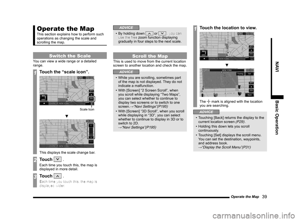
Switch the Scale
You can view a wide range or a detailed
range.
1Touch the “scale icon”.
Scale Icon
▼
This displays the scale change bar.
2Touch .
Each time you touch this, the map is
displayed in more detail.
3Touch .
Each time you touch this, the map is
displayed wider.
ADVICE
• By holding down or , you can
use the free zoom function displaying
gradually in four steps to the next scale.
Scroll the Map
This is used to move from the current location
screen to another location and check the map.
ADVICE
• While you are scrolling, sometimes part
of the map is not displayed. They do not
indicate a malfunction.
• With [Screen] “2 Screen Scroll”, when
you scroll while displaying “Two Maps”,
you can select whether to continue to
display two screens or to switch to one
screen.
→“Navi Settings”(P195)
• With [Screen] “3D Scroll”, when you scroll
while displaying in “3D”, you can select
whether to continue to display in 3D or to
switch to 2D.
→“Navi Settings”(P195)
1Touch the location to view.
▼
The mark is aligned with the location
you are searching.
ADVICE
• Touching [Back] returns the display to the
current location screen (P29).
• Holding this down lets you scroll
continuously.
• Touching [Set] displays the scroll menu.
You can set the destination, waypoints,
and address book.
→“Display the Scroll Menu”(P31)
Page 57 of 226
Route Checking 57
NAVI Route Checking and Changing
Route Checking and Changing
Route Checking
If a route has been set, you can check it.
Check the Next Junction to
Tur n
When the route you are traveling has a
junction ahead where you must turn left or
right, you can have audio guidance and
junction guidance map display provided ahead
of time.
ADVICE
• You must be traveling a route.
• For some maps, only audio guidance is
provided.
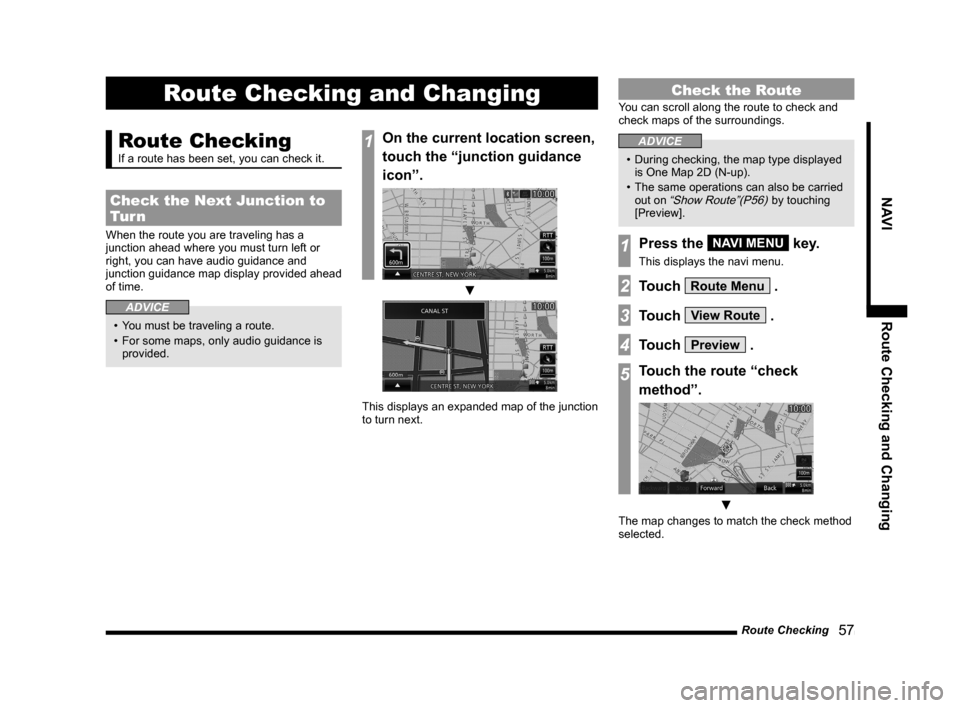
1On the current location screen,
touch the “junction guidance
icon”.
▼
This displays an expanded map of the junction
to turn next.
Check the Route
You can scroll along the route to check and
check maps of the surroundings.
ADVICE
• During checking, the map type displayed
is One Map 2D (N-up).
• The same operations can also be carried
out on
“Show Route”(P56) by touching
[Preview].
1Press the NAVI MENU key.
This displays the navi menu.
2Touch Route Menu .
3Touch View Route .
4Touch Preview .
5Touch the route “check
method”.
▼
The map changes to match the check method
selected.