Page 367 of 444
05
365
Red and yellow triangle: traffic information, for example:
Modified signs
Risk of explosion Narrow carriageway
Road closed
Slippery surface
Demonstration Accident
Danger
Delay
No entry Roadworks
Traffic jam
Main traffic symbols
Black and blue triangle: general information, for example:
Weather reports Traffic reports
Wind Fog
Parking Snow / ice Receiving TA messages
TRAFFIC
Select "Settings". Press on Navigation to display the primary
page then go to the secondary page.
Select "Voice".
Activate / Deactivate "Traffic (TA)".
The TA (Traffic Announcement) function gives priority to TA alert
messages. To operate, this function needs good reception of a radio
station transmitting this type of message. When a traffic report is
transmitted, the current audio source (Radio, CD, USB, ...) is interrupted
automatically to play the TA message. Normal playback of the audio
source resumes at the end of the transmission of the message.
Page 368 of 444
05
Diverting from a route
Press on Navigation to display the primary
page then go to the secondary page.
Select "Traffic messages".
Select "Diversion".
Select the diversion distance by pressing + or -.Select "Recalculate route". The route
will be modified in time and distance.
Select "Confirm".
The route may be diverted following the reception of a traffic
information message.
TRAFFIC
Page 369 of 444
05
367
Map settings
MAP
Map orientation
Select "Map settings".
Select "Orientation". Select:
-
"
Flat view north heading" to keep the map
always North up,
-
"
Flat view vehicle heading" to have the
map follow the direction of travel,
-
"
Perspective view" to display a
perspective view.
Press on Navigation to display the primary
page then go to the secondary page.
Select "Confirm" to save the modifications.
Page 370 of 444
05
Street names are visible on the map from the 100 m scale.
Configure
Select "Aspect".
Select:
-
"
"Day" map colour" to have the map
always in day mode.
-
"
"Night" map colour
" to have the map
always in night mode.
-
"
Automatic day/night
" to have
the brightness of the map adjusted
automatically according to the ambient light
level.
This mode makes use of the vehicle's
sunshine sensor or by manual operation of
the vehicle's lighting.
Select "
Map settings".
Press on Navigation to display the primary
page then go to the secondary page.
MAP
Then "Confirm" to save the modifications.
Page 371 of 444
05
369
Navigation speech synthesis
Volume / Street names
Select "Settings".
Select "Voice".Select "Confirm" to save the modifications.
Press on Navigation to display the primary
page then go to the secondary page.
SETTINGS
Select "Voice synthesis" and/or "Male voice"
and/or "Female voice" and/or "Speak road
names".
Page 380 of 444
07CONNECTED SERVICES
Level 1Level 2
"Connected services"
Primary page
Driving assistance
applications, see following
page on "CITROËN
MULTICITY CONNECT"*. Identification
DUN connection settings
Transfer rate
It may be that certain new
generation Smartphones
are not compatible with this
standard.
Secondary page
Internet navigation via
Bluetooth telephone Dial-Up
Networking (DUN).
* Depending on country.
Page 392 of 444

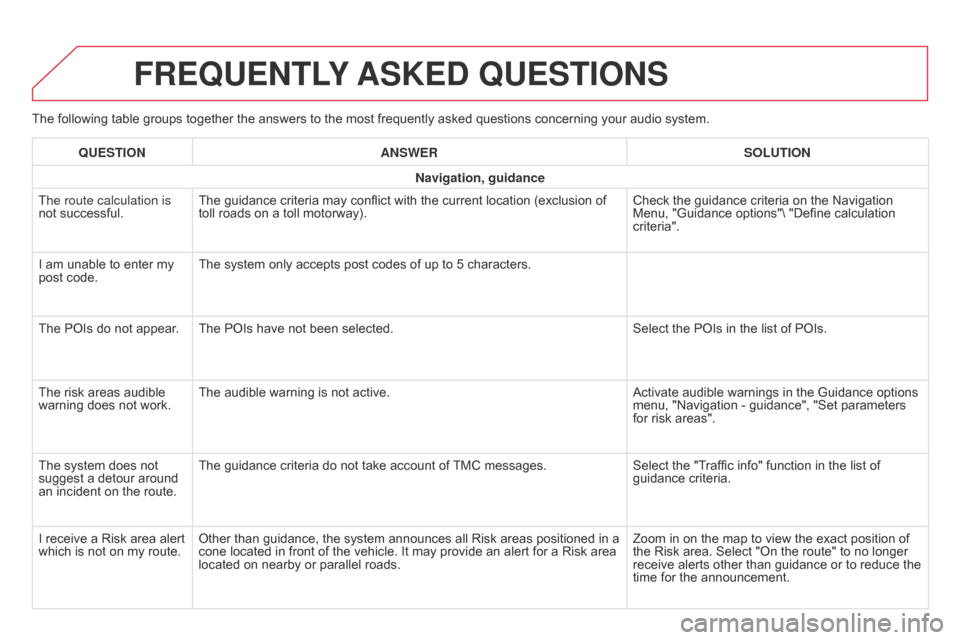
The following table groups together the answers to the most frequently asked questions concerning your audio system.
FREqUENTLY ASKED q UESTIONS
qUESTION ANSWER SOLUTION
Navigation, guidance
The route calculation is
not successful. The guidance criteria may conflict with the current location (exclusion of
toll roads on a toll motorway). Check the guidance criteria on the Navigation
Menu, "Guidance options"\ "Define calculation
criteria".
I am unable to enter my
post code. The system only accepts post codes of up to 5 characters.
The POIs do not appear
. The POIs have not been selected. Select the POIs in the list of POIs.
The risk areas audible
warning does not work. The audible warning is not active.
Activate audible warnings in the Guidance options
menu, "Navigation - guidance", "Set parameters
for risk areas".
The system does not
suggest a detour around
an incident on the route. The guidance criteria do not take account of TMC messages.
Select the "Traffic info" function in the list of
guidance criteria.
I receive a Risk area alert
which is not on my route. Other than guidance, the system announces all Risk areas positioned in a
cone located in front of the vehicle. It may provide an alert for a Risk area
located on nearby or parallel roads. Zoom in on the map to view the exact position of
the Risk area. Select "On the route" to no longer
receive alerts other than guidance or to reduce the
time for the announcement.
Page 400 of 444

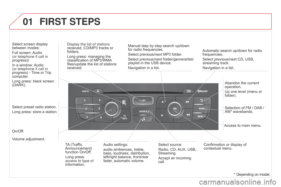
01
Automatic search up/down for radio
frequencies.
Select previous/next CD, USB,
streaming track.
Navigation in a list.
Display the list of stations
received, CD/MP3 tracks or
folders.
Long press: managing the
classification of MP3/WMA
files/update the list of stations
received.
Abandon the current
operation.
Up one level (menu or
folder).
On/Off. Selection of FM / DAB /
AM* wavebands.
Select preset radio station.
Long press: store a station. Select screen display
between modes:
Full screen: Audio
(or telephone if call in
progress)/
In a window: Audio
(or telephone if call in
progress) - Time or Trip
computer.
Long press: black screen
(DARK).
Audio settings:
audio ambiences, treble,
bass, loudness, distribution,
left/right balance, front/rear
fader, automatic volume. Access to main menu.
TA (Traffic
Announcement)
function On/Off.
Long press:
access to type of
information. Select source:
Radio, CD, AUX, USB,
Streaming.
Accept an incoming
call.
Confirmation or display of
contextual menu.
Manual step by step search up/down
for radio frequencies.
Select previous/next MP3 folder.
Select previous/next folder/genre/artist/
playlist in the USB device.
Navigation in a list.
Volume adjustment.
FIRST STEPS
* Depending on model.