2013 RENAULT FLUENCE navigation system
[x] Cancel search: navigation systemPage 17 of 60
Downloaded from www.Manualslib.com manuals search engine short menu . . . . . . . . . . . . . . . . . . . . . . . . . . . . . . . . . . . . . . . . . . . . . . . . . . . . . . . . . . . . . (current page)
JauneNoirNoir texte
15
ENG_UD31433_2
NFA/Principes d’utilisation (XNX - NFA - Renault)
ENG_NW_947-4_TTY_Renault_0
13:22
oPerating PrinciPLes (2/2)
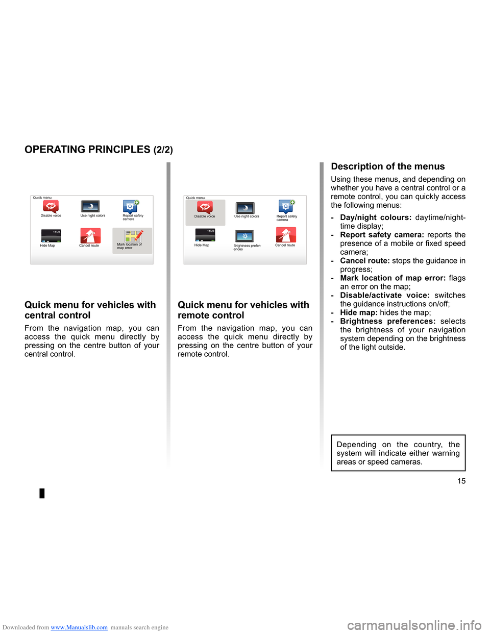
Quick menu for vehicles with
central control
From the navigation map, you can
access the quick menu directly by
pressing on the centre button of your
central control .
Quick menu for vehicles with
remote control
From the navigation map, you can
access the quick menu directly by
pressing on the centre button of your
remote control .
13:22
description of the menus
Using these menus, and depending on
whether you have a central control or a
remote control, you can quickly access
the following menus:
- d ay/night colours: daytime/night-
time display;
- r eport safety camera: reports the
presence of a mobile or fixed speed
camera;
- cancel route: stops the guidance in progress;
- Mark location of map error: flags
an error on the map;
- d isable/activate voice: switches
the guidance instructions on/off;
- Hide map: hides the map;
- Brightness preferences: selects
the brightness of your navigation
system depending on the brightness
of the light outside .
Quick menu
Disable voice Use night colors Report safety
camera
Hide Map Cancel routeMark location of
map error Quick menu
Disable voice Use night colors Report safety
camera
Hide Map Cancel route
Brightness prefer -
ences
Depending on the country, the
system will indicate either warning
areas or speed cameras .
Page 18 of 60
Downloaded from www.Manualslib.com manuals search engine volume . . . . . . . . . . . . . . . . . . . . . . . . . . . . . . . . . . . . . . . . . . . . . . . . . . (up to the end of the DU)
voice activate . . . . . . . . . . . . . . . . . . . . . . . . . . . . . . . . . . . . . . . . . . . (up to the end of the DU)
voice deactivate . . . . . . . . . . . . . . . . . . . . . . . . . . . . . . . . . . . . . . . (up to the end of the DU)
sounds activate . . . . . . . . . . . . . . . . . . . . . . . . . . . . . . . . . . . . . . . . . . . (up to the end of the DU)
sounds deactivate . . . . . . . . . . . . . . . . . . . . . . . . . . . . . . . . . . . . . . . (up to the end of the DU)
16
ENG_UD31500_4
Volume (XNX - NFA - Renault)
ENG_NW_947-4_TTY_Renault_0
15:15
13:2213:22
Volume and voice
VoLuMe and Voice
Volume
changing the volume
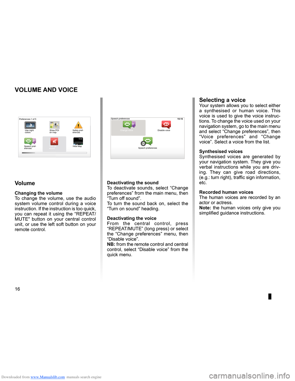
To change the volume, use the audio
system volume control during a voice
instruction . If the instruction is too quick,
you can repeat it using the “REPEAT/
MUTE" button on your central control
unit, or use the left soft button on your
remote control .
deactivating the sound
To deactivate sounds, select “ Change
preferences ” from the main menu, then
“Turn off sound” .
To turn the sound back on, select the
“Turn on sound ” heading .
deactivating the voice
F r o m t h e c e n t r a l c o n t r o l , p r e s s
“REPEAT/MUTE” (long press) or select
the “ Change preferences ” menu, then
“Disable voice ” .
nB: from the remote control and central
control, select “Disable voice” from the
quick menu .
selecting a voiceYour system allows you to select either
a synthesised or human voice . This
voice is used to give the voice instruc-
tions . To change the voice used on your
navigation system, go to the main menu
and select “Change preferences”, then
“ Voice preferences ” and “Change
voice” . Select a voice from the list .
synthesised voices
Synthesised voices are generated by
your navigation system . They give you
verbal instructions while you are driv -
ing . They can give road directions,
(e .g .: turn right), traffic sign information,
etc .
recorded human voices
The human voices are recorded by an
actor or actress .
note: the human voices only give you
simplified guidance instructions .
Safety pref-
erences
Speech pref -
erences Turn off
sound
Hide Map Speech preferences
Change voice
Speech preferences Disable voice
Preferences 1 of 5
Use night
colors Show POI
on map
Page 19 of 60
Downloaded from www.Manualslib.com manuals search engine mapdisplay . . . . . . . . . . . . . . . . . . . . . . . . . . . . . . . . . . . . . . . . . . . . . . . . . . . . . . . . . . . . . . (current page)
map scale . . . . . . . . . . . . . . . . . . . . . . . . . . . . . . . . . . . . . . . . . . . . . . . . . . . . . . . . . . . . . . . . (current page)
map map symbols . . . . . . . . . . . . . . . . . . . . . . . . . . . . . . . . . . . . . . . . . . . . . . . . . . . . (current page)
compass . . . . . . . . . . . . . . . . . . . . . . . . . . . . . . . . . . . . . . . . . . . . . . . . . . . . . . . . . . . . . . . . (current page)
17
ENG_UD25418_2
NFA/Lire une carte (XNX - NFA - Renault)
ENG_NW_947-4_TTY_Renault_0
Marc Bloch
Avenue du Golf
A venue Léon
Marc Bloch
Avenue du Golf A
venue Léon
\f.5k\b
6:52
300\betres
6:\f7
LW 102\f5 \é 66 \é \é RDS-AF 26°C
A2/E35 Utrech
t
1\f
k\b
30
0:05h
Reading a map
reading a MaP
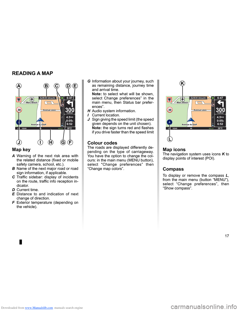
Map key
A Warning of the next risk area with
the related distance (fixed or mobile
safety camera, school, etc .) .
B Name of the next major road or road
sign information, if applicable .
C Traffic sidebar: display of incidents
on the route, traffic info reception in-
dicator .
D Current time .
E Distance to and indication of next
change of direction .
F Exterior temperature (depending on
the vehicle) .
a
FHi
Map iconsThe navigation system uses icons K to
display points of interest (POI) .
compass
To display or remove the compass L ,
from the main menu (button “MENU”),
select “ Change preferences ”, then
“Show compass ” .
Bde
gJ
c
Marc Bloch
Avenue du Golf
Avenue Léon
Marc Bloch
Avenue du Golf A
venue Léon
\f.5k\b
6:52
300\betres
6:\f7
LW 102\f5 \é 66 \é \é RDS-AF 26°C
A2/E35 Utrech
t
1\f
k\b
30
0:05h
G Information about your journey, such
as remaining distance, journey time
and arrival time .
note: to select what will be shown,
select Change preferences ” in the
main menu, then Status bar prefer-
ences” .
H Audio system information .
I Current location .
J Sign giving the speed limit (the speed
given depends on the unit chosen) .
note: the sign turns red and flashes
if you drive faster than the speed limit
colour codesThe roads are displayed differently de-
pending on the type of carriageway .
You have the option to change the col-
ours: in the main menu (MENU button),
select " Change preferences ” then
“Change map colors ” .
L
K
Page 23 of 60
Downloaded from www.Manualslib.com manuals search engine JauneNoirNoir texte
21
ENG_UD31424_2
NFA/Entrer une destination (XNX - NFA - Renault)
ENG_NW_947-4_TTY_Renault_0
GOVIROFLA Y
CHAVILL ELE CHESNAY
SEVRES
VIROFLA Y
CHA
VILL E
LE CHESNAY SEVRES
L I V E
0:13 \f
9.4 \bm
IQ Routes
20 mai, 9:50
Avenue Roger-Salengr\
o
Chaville
entering a destination (4/4)
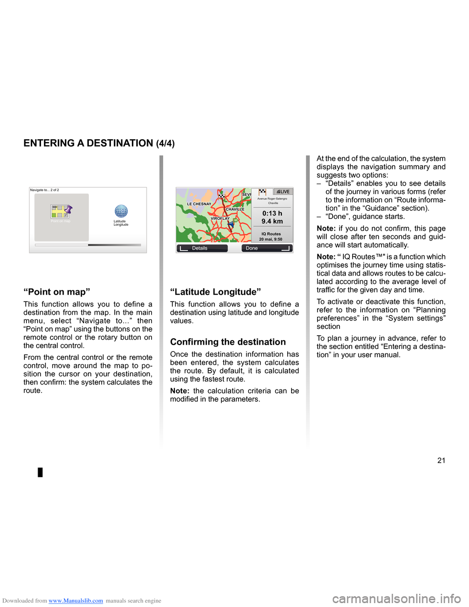
“Latitude Longitude ”
This function allows you to define a
destination using latitude and longitude
values .
confirming the destination
Once the destination information has
been entered, the system calculates
the route . By default, it is calculated
using the fastest route .
n ote: the calculation criteria can be
modified in the parameters .
“Point on map ”
This function allows you to define a
destination from the map . In the main
menu, select “ Navigate to . . .” then
“Point on map” using the buttons on the
remote control or the rotary button on
the central control .
From the central control or the remote
control, move around the map to po -
sition the cursor on your destination,
then confirm: the system calculates the
route .
Navigate to . . . 2 of 2
Details Done
Latitude
Longitude
At the end of the calculation, the system
displays the navigation summary and
suggests two options:
– “Details ” enables you to see details
of the journey in various forms (refer
to the information on “Route informa-
tion” in the “Guidance” section) .
– “Done”, guidance starts .
n ote: if you do not confirm, this page
will close after ten seconds and guid -
ance will start automatically .
note: “ IQ Routes™" is a function which
optimises the journey time using statis-
tical data and allows routes to be calcu-
lated according to the average level of
traffic for the given day and time .
To activate or deactivate this function,
refer to the information on “ Planning
preferences ” in the “System settings”
section
To plan a journey in advance, refer to
the section entitled “Entering a destina-
tion” in your user manual .
Point on map
Page 24 of 60
Downloaded from www.Manualslib.com manuals search engine guidanceactivation . . . . . . . . . . . . . . . . . . . . . . . . . . . . . . . . . . . . . . . . . . . . . . . . . . . . . . . . . . (current page)
screen navigation display . . . . . . . . . . . . . . . . . . . . . . . . . . .(up to the end of the DU)
detailed route . . . . . . . . . . . . . . . . . . . . . . . . . . . . . . . . . . . . . . . . (up to the end of the DU)
22
ENG_UD31434_2
NFA/Guidage (XNX - NFA - Renault)
ENG_NW_947-4_TTY_Renault_0
Jaune NoirNoir texte
9:13am
Guidance
guidance (1/4)
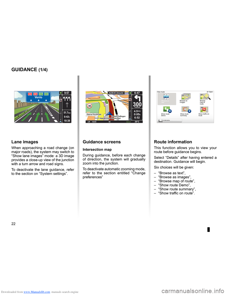
guidance screens
intersection map
During guidance, before each change
of direction, the system will gradually
zoom into the junction .
To deactivate automatic zooming mode,
refer to the section entitled “ Change
preferences ”
route information
This function allows you to view your
route before guidance begins .
Select “Details” after having entered a
destination . Guidance will begin .
Six choices will be given:
– “Browse as text”,
– “Browse as images ”,
– “Browse map of route”,
– “Show route Demo”,
– “Show route summary”,
– “Show traffic on route” .
View route
Browse as
text Browse as
images Browse
map of
route
Show route
Demo Show route
summary
Find alternative
A2
A67 D27 E34Venlo
10:39
9:57
0:42h
51.7km14
km
Lane images
When approaching a road change (on
major roads), the system may switch to
“Show lane images” mode: a 3D image
provides a close-up view of the junction
with a turn arrow and road signs .
To deactivate the lane guidance, refer
to the section on “System settings” .
30
4.5km
6:52
300metres
6:47
LW 10245 \1 66 \1 \1 \fDS-\bF 26°C
\b2/E35 Utrech
t
14
km
0:05hShow traffic on
route
Page 28 of 60

Downloaded from www.Manualslib.com manuals search engine 26
ENG_UD31435_3
NFA/Rechercher alternative (XNX - NFA - Renault)
ENG_NW_947-4_TTY_Renault_0
LIVE
Find alternative
Find aL ternatiVe
itinerary with waypoints
To add waypoints to your route, press
“MENU/SET" in the main menu, select
"Find alternative ”, “Travel via . . .”, then
enter the waypoint address .
Travel via . . .
Home FavoriteAddress
Recent
destina -
tion Point of Interest
TomTom Places
Main Menu 1 of 3
Navigate to . . . Find alternative
Traffic
Change pref -
erences LIVE services
Safety Alerts
Current position:
Find alternative
Avoid roadblock
Minimise
delays
Show route
summary Avoid part of
route Travel via . . .
Calculate alter
-
native
Current position: Current position:
The system calculates the route taking
the detour into account .
note: you can add several waypoints
to your route .
Planning a route in advance
You can use your navigation system to
plan journeys in advance by selecting
both your starting point and your des -
tination . For example, to find out how
long a journey is going to take before
you start, or to check the route of a jour-
ney you are planning . To access the menu, from the main
m e n u ( M E N U / S E T b u t t o n ) , s e l e c t
"Prepare route
” .
Select a starting point in the same way
as you would select your destination .
Select a destination .
Choose the type of route, then confirm .
The system plans the route and allows
you to view the details .
Page 29 of 60

Downloaded from www.Manualslib.com manuals search engine traffic information . . . . . . . . . . . . . . . . . . . . . . . . . . . . . . . . . . (up to the end of the DU)
detour . . . . . . . . . . . . . . . . . . . . . . . . . . . . . . . . . . . . . . . . . . . . . . . . . . . (up to the end of the DU)
second route . . . . . . . . . . . . . . . . . . . . . . . . . . . . . . . . . . . . . . . . . (up to the end of the DU)
navigation . . . . . . . . . . . . . . . . . . . . . . . . . . . . . . . . . . . . . . . . . . . . . (up to the end of the DU)
27
ENG_UD22840_2
NFA/Info Trafic (XNX - NFA - Renault)
ENG_NW_947-4_TTY_Renault_0
LIVE14
km14
km
Traffic information
traFFic inForMation (1/3)
a
F
e
d
c
BMain Menu 1 of 3
Navigate to . . . Find alternative Traffic
Change prefer -
ences LIVE services
Safety Alerts
Current position:
the “traffic info” service
“Traffic info ” is a service available on
your navigation system which allows
you to receive up-to-date traffic infor -
mation from the best local sources .
The traffic info service uses TMC in -
formation transmitted on the FM band .
This service flags up events as points
on the map and covers major roads . It
is updated approximately every 15 min-
utes .
n ote: the menu title is “HD Traffic™"
depending on the LIVE Services used .
display
the “t raffic info” function
The navigation system indicates traffic
incidents:
– by displaying symbols on the map
(list of icons at the end of the sec -
tion);
– with voice messages .
Depending on the operating status of
the “ Traffic info ” service, the following
icons are displayed on the traffic side-
bar:
A Your device is searching for an FM
station broadcasting traffic informa -
tion .
B Traffic information is up-to-date or
being updated .
C Traffic information has not been up-
dated for at least 9 minutes .
D Traffic information has not been up-
dated for at least 14 minutes .
E Traffic information has not been up-
dated for at least 19 minutes .
F Traffic information has not been up-
dated for at least 24 minutes .
the traffic bar
The side traffic bar displayed in guid
-
ance mode, shows the latest traffic in-
formation for your route .
note: the traffic sidebar differs depend -
ing on the source used . Bar 1 with the
LIVE Services connected .
Bar 2 if the RDS-TMC source is con -
nected .
n ote: please see the “LIVE Services”
chapter for more information about the
“HD Traffic™" service .
12
The availability of the “Traffic Info”
service varies according to country .
Page 36 of 60

Downloaded from www.Manualslib.com manuals search engine favouriteadd . . . . . . . . . . . . . . . . . . . . . . . . . . . . . . . . . . . . . . . . . . . . . . . . . . (up to the end of the DU)
34
ENG_UD31467_2
NFA/Gérer les favoris (XNX - NFA - Renault)
ENG_NW_947-4_TTY_Renault_0
Jaune NoirNoir texte
Add and manage favourites
add and Manage F aVourites (1/2)
creating an entry
In the main menu (MENU/SET button),
select "Add Favorite “ .
You can select the location for your
Favourite from the following list:
“Home”
You can set your home location as a
Favourite .
“Favorite”
Not used
“address”
When you enter an address, you can
choose from four options:
– City center ,
– Street and house number ,
– Zip Code,
– Crossing or intersection .
“recent destination”
Select a favourite location from the list
of those you have recently entered as a
destination . “Point on map
”
Select the location of your Favourite
using the cursor, then select “ Done”
using the soft button .
“t omt om Places™”
Select a place using TomTom Places™,
then select “Done ” .
“Point of interest ”
You can add a Point of Interest (POI) as
a Favourite from the list below:
– POI near you: to search from a list of
POIs near your current position .
– POI in city: to choose a POI in a par-
ticular town or city . You have to spec-
ify a town or city .
– POI near Home: to search from a list
of POIs near your Home location .
If you are currently navigating to a des-
tination, you can also select from a list
of POIs which are on your route or near
your destination . . Choose one of these
options:
– POI along route,
– POI near destination .
Give your Favourite a name that is easy to remember . Your navigation system will
always suggest a name, usually the address of the Favourite . To enter a name,
just start typing .
Main Menu 2 of 3
Cancel route Browse
map
Map correc-
tionsAdd
Favorite
View
route Remove SD
card
Current position:
Add Favorite:1/2
Home FavoriteAddress
Recent desti -
nation TomTom
Places Point of Interest