2013 NISSAN GT-R engine
[x] Cancel search: enginePage 269 of 315

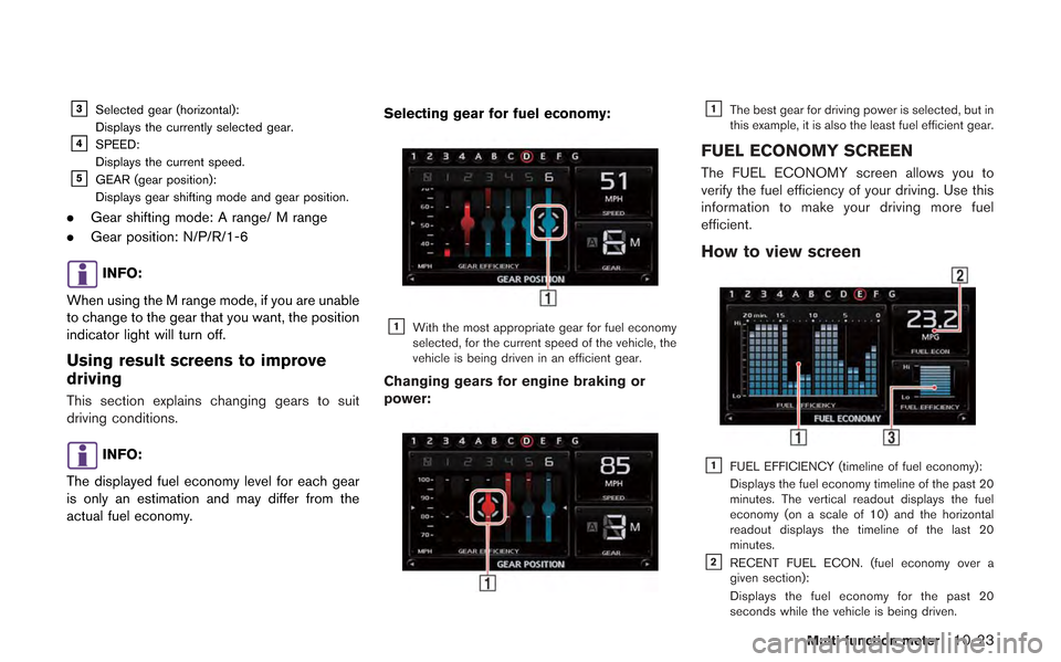
&3Selected gear (horizontal):
Displays the currently selected gear.
&4SPEED:
Displays the current speed.
&5GEAR (gear position):
Displays gear shifting mode and gear position.
.Gear shifting mode: A range/ M range
. Gear position: N/P/R/1-6
INFO:
When using the M range mode, if you are unable
to change to the gear that you want, the position
indicator light will turn off.
Using result screens to improve
driving
This section explains changing gears to suit
driving conditions.
INFO:
The displayed fuel economy level for each gear
is only an estimation and may differ from the
actual fuel economy. Selecting gear for fuel economy:
&1With the most appropriate gear for fuel economy
selected, for the current speed of the vehicle, the
vehicle is being driven in an efficient gear.
Changing gears for engine braking or
power:
&1The best gear for driving power is selected, but in
this example, it is also the least fuel efficient gear.
FUEL ECONOMY SCREEN
The FUEL ECONOMY screen allows you to
verify the fuel efficiency of your driving. Use this
information to make your driving more fuel
efficient.
How to view screen
&1FUEL EFFICIENCY (timeline of fuel economy):
Displays the fuel economy timeline of the past 20
minutes. The vertical readout displays the fuel
economy (on a scale of 10) and the horizontal
readout displays the timeline of the last 20
minutes.
&2RECENT FUEL ECON. (fuel economy over a
given section):
Displays the fuel economy for the past 20
seconds while the vehicle is being driven.
Multi function meter10-23
Page 275 of 315

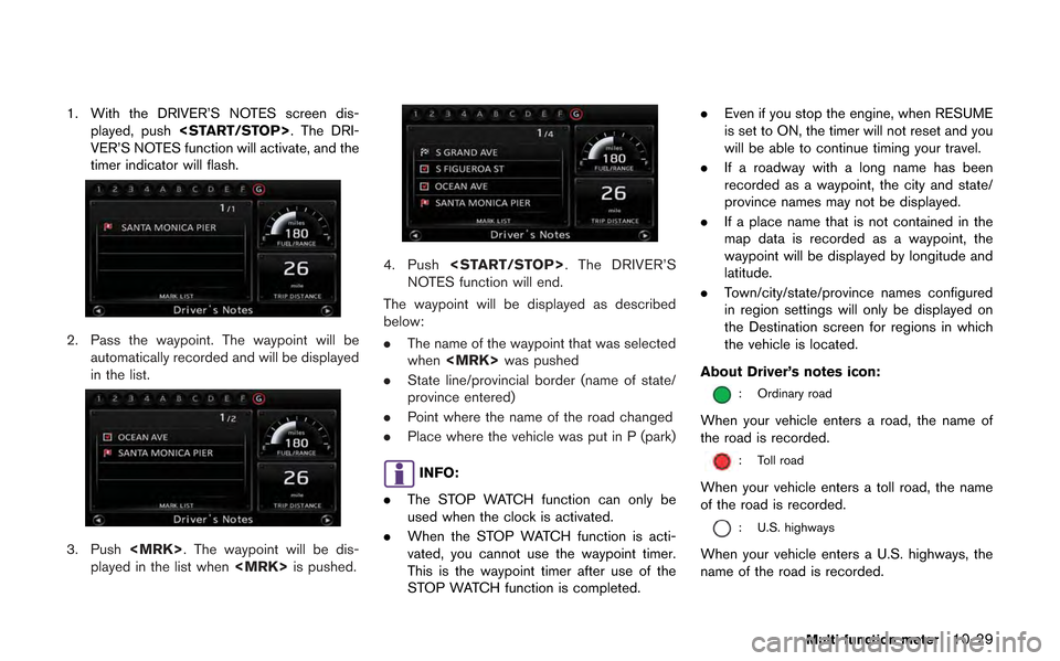
1. With the DRIVER’S NOTES screen dis-played, push
VER’S NOTES function will activate, and the
timer indicator will flash.
2. Pass the waypoint. The waypoint will be automatically recorded and will be displayed
in the list.
3. Push
played in the list when
4. Push
NOTES function will end.
The waypoint will be displayed as described
below:
. The name of the waypoint that was selected
when
. State line/provincial border (name of state/
province entered)
. Point where the name of the road changed
. Place where the vehicle was put in P (park)
INFO:
. The STOP WATCH function can only be
used when the clock is activated.
. When the STOP WATCH function is acti-
vated, you cannot use the waypoint timer.
This is the waypoint timer after use of the
STOP WATCH function is completed. .
Even if you stop the engine, when RESUME
is set to ON, the timer will not reset and you
will be able to continue timing your travel.
. If a roadway with a long name has been
recorded as a waypoint, the city and state/
province names may not be displayed.
. If a place name that is not contained in the
map data is recorded as a waypoint, the
waypoint will be displayed by longitude and
latitude.
. Town/city/state/province names configured
in region settings will only be displayed on
the Destination screen for regions in which
the vehicle is located.
About Driver’s notes icon:
: Ordinary road
When your vehicle enters a road, the name of
the road is recorded.
: Toll road
When your vehicle enters a toll road, the name
of the road is recorded.
: U.S. highways
When your vehicle enters a U.S. highways, the
name of the road is recorded.
Multi function meter10-29
Page 283 of 315

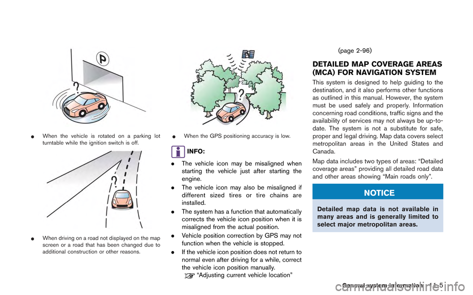
*When the vehicle is rotated on a parking lot
turntable while the ignition switch is off.
*When driving on a road not displayed on the map
screen or a road that has been changed due to
additional construction or other reasons.
*When the GPS positioning accuracy is low.
INFO:
. The vehicle icon may be misaligned when
starting the vehicle just after starting the
engine.
. The vehicle icon may also be misaligned if
different sized tires or tire chains are
installed.
. The system has a function that automatically
corrects the vehicle icon position when it is
misaligned from the actual position.
. Vehicle position correction by GPS may not
function when the vehicle is stopped.
. If the vehicle icon position does not return to
normal even after driving for a while, correct
the vehicle icon position manually.
“Adjusting current vehicle location” (page 2-96)
DETAILED MAP COVERAGE AREAS
(MCA) FOR NAVIGATION SYSTEM
This system is designed to help guiding to the
destination, and it also performs other functions
as outlined in this manual. However, the system
must be used safely and properly. Information
concerning road conditions, traffic signs and the
availability of services may not always be up-to-
date. The system is not a substitute for safe,
proper and legal driving. Map data covers select
metropolitan areas in the United States and
Canada.
Map data includes two types of areas: “Detailed
coverage areas” providing all detailed road data
and other areas showing “Main roads only”.
NOTICE
Detailed map data is not available in
many areas and is generally limited to
select major metropolitan areas.
General system information11-5
Page 293 of 315

tion taken with permission from Canadian
authorities, including:*CHer Majesty the Queen
in Right of Canada,*CQueen’s Printer for
Ontario,*CCanada Post Corporation, Geo-
Base®.
NAVTEQ holds a non-exclusive license from the
United States Postal Service
®to publish and
sell ZIP+4®information.
*CUnited States Postal Service®2008. Prices
are not established, controlled or approved by
the United States Postal Service
®. The following
trademarks and registrations are owned by the
USPS: United States Postal Service, USPS, and
ZIP+4.
Terms and conditions
Personal Use Only. You agree to use this Data
together with Nissan Automotive Products for
the solely personal, non-commercial purposes
for which you were licensed, and not for service
bureau, timesharing or other similar purposes.
Accordingly, but subject to the restrictions set
forth in the following paragraphs, you may copy
this Data only as necessary for your personal
use to (i) view it, and (ii) save it, provided that
you do not remove any copyright notices that
appear and do not modify the Data in any way.
You agree not to otherwise reproduce, copy,
modify, decompile, disassemble or reverse engineer any portion of this Data, and may not
transfer or distribute it in any form, for any
purpose, except to the extent permitted by
mandatory laws. Multi-disc sets may only be
transferred or sold as a complete set as
provided by HITACHI and not as a subset
thereof.
Restrictions.
Except where you have been
specifically licensed to do so by HITACHI, and
without limiting the preceding paragraph, you
may not (a) use this Data with any products,
systems, or applications installed or otherwise
connected to or in communication with vehicles,
capable of vehicle navigation, positioning, dis-
patch, real time route guidance, fleet manage-
ment or similar applications; or (b) with or in
communication with any positioning devices or
any mobile or wireless-connected electronic or
computer devices, including without limitation
cellular phones, palmtop and handheld compu-
ters, pagers, and personal digital assistants or
PDAs.
Warning. The Data may contain inaccurate or
incomplete information due to the passage of
time, changing circumstances, sources used
and the nature of collecting comprehensive
geographic data, any of which may lead to
incorrect results.
No Warranty. This Data is provided to you “as is,” and you agree to use it at your own risk.
HITACHI and its licensors (and their licensors
and suppliers) make no guarantees, representa-
tions or warranties of any kind, express or
implied, arising by law or otherwise, including
but not limited to, content, quality, accuracy,
completeness, effectiveness, reliability, fitness
for a particular purpose, usefulness, use or
results to be obtained from this Data, or that the
Data or server will be uninterrupted or error-free.
Disclaimer of Warranty:
HITACHI AND ITS
LICENSORS (INCLUDING THEIR LICENSORS
AND SUPPLIERS) DISCLAIM ANY WARRAN-
TIES, EXPRESS OR IMPLIED, OF QUALITY,
PERFORMANCE, MERCHANTABILITY, FIT-
NESS FOR A PARTICULAR PURPOSE OR
NONINFRINGEMENT. Some States, Territories
and Countries do not allow certain warranty
exclusions, so to that extent the above exclusion
may not apply to you.
Disclaimer of Liability: HITACHI AND ITS
LICENSORS (INCLUDING THEIR LICENSORS
AND SUPPLIERS) SHALL NOT BE LIABLE TO
YOU: IN RESPECT OF ANY CLAIM, DEMAND
OR ACTION, IRRESPECTIVE OF THE NATURE
OF THE CAUSE OF THE CLAIM, DEMAND OR
ACTION ALLEGING ANY LOSS, INJURY OR
DAMAGES, DIRECT OR INDIRECT, WHICH
MAY RESULT FROM THE USE OR POSSES-
General system information11-15