Page 97 of 204

96
Map MenuMap Legend
Navigation
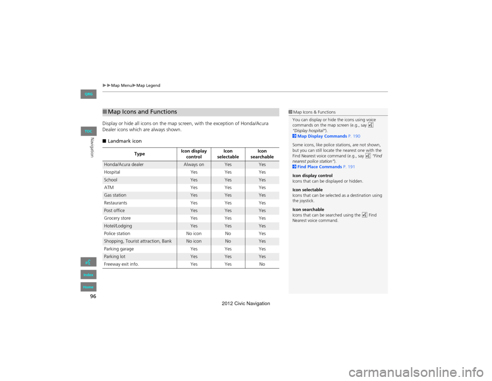
Display or hide all icons on the map screen, with the exception of Honda/Acura
Dealer icons which are always shown.
■ Landmark icon
■Map Icons and Functions
Type Icon display
control Icon
selectable Icon
searchable
Honda/Acura dealerAlways onYesYes
Hospital YesYes Yes
SchoolYesYesYes
ATM YesYesYes
Gas stationYesYesYes
Restaurants YesYesYes
Post officeYesYesYes
Grocery store YesYesYes
Hotel/LodgingYesYesYes
Police station No iconNoYes
Shopping, Tourist attraction, BankNo iconNoYes
Parking garage YesYes Yes
Parking lotYesYesYes
Freeway exit info. YesYes No
1Map Icons & Functions
You can display or hide the icons using voice
commands on the map screen (e.g., say d
“Display hospital” ).
2 Map Display Commands P. 190
Some icons, like police stations, are not shown,
but you can still locate th e nearest one with the
Find Nearest voice command (e.g., say d “Find
nearest police station” ).
2 Find Place Commands P. 191
Icon display control
Icons that can be displayed or hidden.
Icon selectable
Icons that can be selected as a destination using
the joystick.
Icon searchable
Icons that can be searched using the d Find
Nearest voice command.
QRG
Index
Home
TOC
2012 Civic Navigation
Page 98 of 204

97
Map MenuMap Legend
Navigation
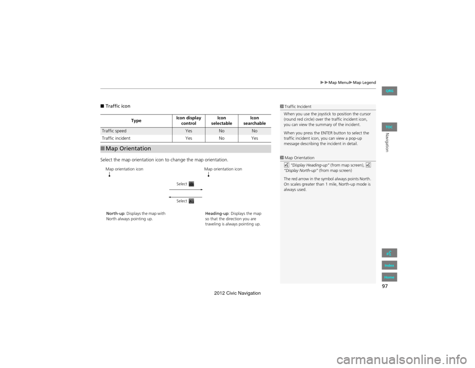
■Traffic icon
Select the map orientation icon to change the map orientation.
Type Icon display
control Icon
selectable Icon
searchable
Traffic speedYesNoNo
Traffic incident YesNoYes
■Map Orientation
1 Traffic Incident
When you use the joystick to position the cursor
(round red circle) over the traffic incident icon,
you can view the summa ry of the incident.
When you press the ENTER button to select the
traffic incident icon, you can view a pop-up
message describing the incident in detail.
1 Map Orientation
d “Display Heading-up” (from map screen), d
“Display North-up” (from map screen)
The red arrow in the symbol always points North.
On scales greater than 1 mile, North-up mode is
always used.
Map orientation icon
North-up: Displays the map with
North always pointing up. Map orientation icon
Heading-up : Displays the map
so that the direction you are
traveling is always pointing up.
Select
Select
QRG
Index
Home
TOC
2012 Civic Navigation
Page 99 of 204
98
Map MenuMap Legend
Navigation
Display and save your current location for future use as a destination. The address,
latitude, longitude, and elevation of your current location are displayed.
■ To save your current location in the address book:
1.Select the vehicle icon on the map.
2. Select Save.
3. Edit the name, phone number, and
category.
2 Address Book P. 30
4. Select OK.
■
Current Location1 Current Location
d “Display Current Location” (on map screen)
You can also save the current location by saying
d “Register the Current Location” .
If you have PIN-protected your address book,
enter your PIN when prompted. Select OK. PINs
are optional.
2 PIN Numbers P. 36
The elevation is not displayed if the system is
receiving insufficient GPS information. When
elevation is displayed, it may differ with roadside
elevation signs by ±100 feet or more.
Saving your current locati on does not change or
cancel your current route.
QRG
Index
Home
TOC
2012 Civic Navigation
Page 100 of 204
99
Map MenuFM Traffic
Navigation
FM Traffic
HMAP MENU (on map) Traffic Incidents
View and avoid specific incidents and/or congestion on your route: 1.Select On Route .
2. Select an incident from the list.
The system displays the map
screen and the incident location.
3. Select Traffic Detail.
1FM Traffic
You must be in or near a traffic-enabled city to
receive coverage for that area. FM Traffic is
available in the lower 48 states and Hawaii.
Automatic traffic rerouting may not provide a
detour route depending on circumstances.
d “Display traffic incidents” , d “Display traffic
list”
You can also display the traffic incidents from the
INFO screen.
You can display traffic incidents and related
information on the map screen using voice
commands.
2 Map Display Commands P. 190
Continued
QRG
Index
Home
TOC
2012 Civic Navigation
Page 101 of 204
100
Map MenuFM Traffic
Navigation
4.Select Avoid.
Repeat step 2 to 4 as necessary.
5. Select Reroute .
The system recalculates a detour
route that avoids the traffic
incidents.
1FM Traffic
You can choose to avoid up to 10 traffic
incidents. It is not always possible for the system
to calculate a route that avoids all traffic
incidents or specific traffic incidents you select.
The “On Route” tab on the Traffic List screen is
only available during route guidance.
You cannot select an incident to avoid from the
“All” tab.
You can also detour around a traffic incident
manually if you encounter an unexpected
obstacle.
2 Taking a Detour P. 102
QRG
Index
Home
TOC
2012 Civic Navigation
Page 102 of 204

101
Navigation
Changing Your Route
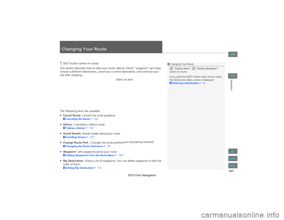
HDEST button (when en route)
This section describes how to alter your route, add an interim “waypoint” (pit stop),
choose a different destination, cancel your current destination, and continue your
trip after stopping.
Select an item.
The following items are available:
• Cancel Route : Cancels the ro ute guidance.
2Canceling the Route P. 102
• Detour : Calculates a detour route.
2Taking a Detour P. 102
• Avoid Streets : Avoids streets along your route.
2Avoiding Streets P. 102
• Change Route Pref. : Changes the route preferen ces (calculating method).
2
Changing the Route Preference P. 78
• Waypoint : Sets waypoints along your route.
2Adding Waypoints from the Route Menu P. 104
• My Destination : Shows a list of waypoints. You can delete waypoints or edit the
order of them.
2 Editing My Destination P. 107
1Changing Your Route
d “Display Menu” , d “Display Navigation”
(when en route)
If you press the DEST button when not en route,
the Destination Menu screen is displayed.
2 Entering a Destination P. 56
QRG
Index
Home
TOC
2012 Civic Navigation
Page 103 of 204

102
Changing Your RouteCanceling the Route
Navigation
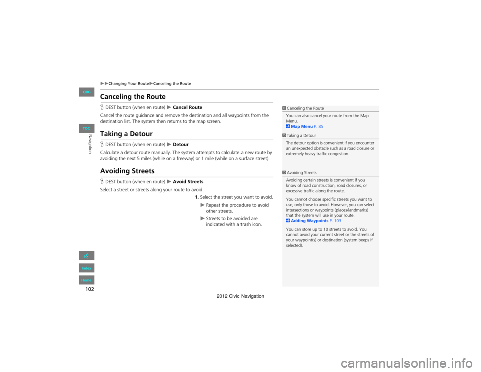
Canceling the Route
HDEST button (when en route) Cancel Route
Cancel the route guidance and remove the destination and all waypoints from the
destination list. The system th en returns to the map screen.
Taking a Detour
HDEST button (when en route) Detour
Calculate a detour route manually. The system attempts to calculate a new route by
avoiding the next 5 miles (while on a freeway) or 1 mile (while on a surface street).
Avoiding Streets
H DEST button (when en route) Avoid Streets
Select a street or streets along your route to avoid. 1.Select the street you want to avoid.
Repeat the procedure to avoid
other streets.
Streets to be avoided are
indicated with a trash icon.
1Canceling the Route
You can also cancel your route from the Map
Menu.
2 Map Menu P. 85
1Taking a Detour
The detour option is convenient if you encounter
an unexpected obstacle such as a road closure or
extremely heavy traffic congestion.
1 Avoiding Streets
Avoiding certain streets is convenient if you
know of road construction, road closures, or
excessive traffic along the route.
You cannot choose specific streets you want to
use, only those to avoid. However, you can select
intersections or waypoi nts (places/landmarks)
that the system will use in your route.
2 Adding Waypoints P. 103
You can store up to 10 streets to avoid. You
cannot avoid your current street or the streets of
your waypoint(s) or destination (system beeps if
selected).
QRG
Index
Home
TOC
2012 Civic Navigation
Page 104 of 204
103
Changing Your RouteAdding Waypoints
Navigation
2.Select OK.
The system calculates a new
route.
Adding Waypoints
Add up to four waypoints (pit stops) along the route to your destination.
Waypoints are displayed on the map
screen as small, numbered red flags.
The route follows the waypoints in
the order they are listed in the
destination list.
1Adding Waypoints
Waypoints allow you to stop for gas or food, for
example, and then continue on to your
destination.
Press the MAP/GUIDE button to return to the
map screen without adding a waypoint at any
time.
The search corridor used for adding waypoints
can be adjusted.
2 Edit Waypoint Search Area P. 45
You can delete waypoints or edit the order of
waypoints in the destination list.
2 Editing My Destination P. 107
QRG
Index
Home
TOC
2012 Civic Navigation