Page 153 of 176

152Navigation System
Frequently Asked Questions
Display, Accessories
Rear Camera
Miscellaneous Other Questions
ProblemSolution
The display appears dim when starting the car in really cold
weather. Is there a problem? No. This is normal, and it will become brighter after a few minutes.
Problem Solution
When I shift gears, the rear camera image is delayed. When shifting into or out of reverse, you may experience delays when the
screen image switches between the navigation screen and the rear camera
image. This is normal.
The rear camera image is too dark or too bright. How do I
adjust the brightness? While the camera image is displaye
d, use the rotating portion of the
Interface Dial (knob ) to adjust the brightness . This adjustment does not
affect the SETUP screen brightness adjustments.
Problem Solution
My clock frequently changes forward and backward by one
hour. Why is this? The clock is being automatically set ba
sed on your GPS location. If you live
and work on the boundary between two time zones, you can turn off this
feature. See page 110.
When driving near a time zone border, the time changes even
though I am not near the time zone. Why is this? The time zone borders are only appr
oximated in the system. Depending on
the geography of the time zone boundary, the switch to a different zone can
be erratic. See page 110.
My state does not observe dayl ight savings time. How do I
turn off this feature? You can turn off this feature. See page 109.
Page 154 of 176

Navigation System153
Frequently Asked Questions
Daylight savings time occurred, but the navigation system did
not change time even though SETUP shows Auto Daylight
is ON . Go to the
Clock adjustment screen in SETUP and select DST Selection.
Ensure that the correct DST schedule is selected. For more information, see
Clock Adjustment on page 109.
The navigation system automatic daylight time feature is not
switching the navigation system clock on the correct dates.
Why is this? 1) Go to the
Clock adjustment screen in SETUP and ensure that Auto
Daylight is ON .
2) The navigation system is designed to switch to daylight savings time
according to the months selected in the DST schedule selection screen.
Ensure that the appropriate schedule is selected. For more information,
see Clock Adjustment on page 109.
The navigation system clock switched by one hour for no
apparent reason. Wh at can cause this? 1) You may be driving near
a time zone boundary (see Auto Daylight on
page 109).
2) The navigation system does not switch between standard and daylight
savings time. Set Auto Daylight to ON on the Clock adjustment
screen in SETUP, and ensure that the correct month switching schedule
is chosen on the DST schedule selection screen. See page 109 for more
information.
My battery was disconnected or went dead, and the
navigation system is asking for a code. Where do I find this
code? There should be a card in the glove box with the anti-theft code for the
navigation/audio syst
em. This card contains the 4-digit security code and
serial number. If you cannot find it , your dealer can help you out.
I speak a language other than English. When will other
languages be available for the navigation system? This is being considered
as a future enhancement.
Problem
Solution
Page 155 of 176

154Navigation System
Troubleshooting
* If the error persists, or is shown for a wide area, see your dealer.
Screen Error MessageSolution
Navigation system is unable to acquire a proper GPS
signal.Make sure there is nothing on the dashboard
blocking the GPS antenna (aftermarket
metallic window tinting or aftermarket devices placed on the dashboard like radar
detectors, cell phones, or loose items). If the dashboard is clear of objects, move the
vehicle to an open space away from tall buildings, trees, etc.
Navigation unit door is open or No DVD disc is inserted.
Please check system. Make sure that the navigation DVD disc is
inserted with the label side up and the
navigation unit door is fully snapped closed (see page 126).
No DVD disc. Please check system. Check that the navigation DVD disc is inserted with the label side up (page 126). If the
problem persists, see your dealer.
DVD disc reading error (unformatted). Please consult
your dealer. Check the DVD disc surface for deep scratches or other damage. Make sure you are
using a navigation DVD (white-colored labe
l). The system cannot read other mapping
databases or video DVDs. If the problem persists, see your dealer.
Display temp is too high. System will shut down until
display cools down. This message will appear briefly when the display temperature is too high, and then the
display will turn off until the temperature
cools down. The system will turn back on
when the display cools down.
Outside temperature is low. System will take a while to
start up. The temperature is below -22°F and the na
vigation ECU has difficulty reading the
DVD. The system will start up when the temperature warms up.
Navigation system voice rec ognition cannot be activated
when another unit is using the audio system. Bluetooth
® HandsFreeLink® can override the navigation system. Make sure the
HFL
TALK button is not on when you press the NAVI TALK button, or the message will
appear. Simply press the HFL BACK button to resume control of the navigation voice
buttons.
Route has not been complete d. Please try again from a
different location. This message will appear when you are routing to or from a place (new area) that is not
in the database. Try planning a different
route to or from a different location.*
No alternate route found. Original route wi ll be followed. No alternative route method was found. The original route method will be used.*
Ensure that a road name is displayed at the bottom of the map.
This destination cannot be found in database .The destination was not found in the database. Try another destination nearby, or select
the destination with the Interface Dial.*
Vehicle is out of the database coverage area. The vehicle is located outside of the mapped area provided by your navigation DVD.
See page 128 for map coverage.
Page 156 of 176

Navigation System155
Glossary
Glossary
The following is a glossary of terms
pertaining to the voice recognition
navigation system.
Average Fuel - The average fuel
economy value as displayed by the
Trip computer screen.
Avoid Area - Areas you wish to avoid
can be entered into the system, and
will be avoided while routing.
Breadcrumbs - Off-road tracking dots
that can be followe d on the map to
retrace your route back to a mapped
(digitized) road. This function can be
turned on/off in the SETUP screen
(Other ).
Database - This consists of the map
data, and the POI (Points of Interest)
data stored on the DVD.
DCA - Detailed Coverage Area. The
main metropolitan areas in the lower
48 U.S. states, Hawaii, and southern
Canada are mapped to this level. See
page 128 for a list of these areas. Digitized Road -
A road that appears on
the navigation screen. The road name
will appear at the bottom of the
navigation screen. If the user drives
“off road,” the navigation system will
display “breadcrumbs,” depending on
how far you drive from a mapped
road.
Disclaimer Screen - Screen containing
cautionary information. It is meant to
be read carefully and acknowledged
by the client when using the
navigation system.
DVD or DVD-ROM - Digital Versatile
Disc. The navigation program and
database resides on this disc. For
information on how to order a
replacement or update DVD, see
page 125.
Elapsed Time - Elapsed Time for the
current trip as displayed by the Trip
computer screen. FAQ -
Frequently Asked Questions. See
page 146 for a list of client FAQs and
troubleshooting information.
GPS - Global Positioning System. A
network of 24 satellites in orbit
around the earth. The navigation
system can simultaneously receive
signals from up to 12 satellites to
accurately position the vehicle on the
map.
GPS Antenna - Located under the
dashboard. Electronic items operating
in this general location can interfere
with the GPS signal.
HFL - Bluetooth ® HandsFreeLink®.
Your vehicle is equipped with this
feature, which uses Bluetooth
technology as a wireless link between
the vehicle and your Bluetooth-
compatible cell phone.
Icon - Symbol representing Points of
Interest (POI) that can be displayed
on the map.
Page 157 of 176

156Navigation System
Glossary
Initialization - This refers to the period
needed to reacquire the GPS satellite
orbital information whenever the
navigation system power has been
disconnected. This can take 10 to 45
minutes with the ve hicle out in an
open area.
Instant Fuel - The current
instantaneous fuel economy value as
displayed by the Trip computer
screen.
LCD - Liquid Crystal Display. The
navigation screen.
Map Matching - The received GPS information allows the navigation
system to position the vehicle on the
map. Map matching has occurred if
the map screen is displaying the
current street name in the bottom-
shaded area.
Mic - Abbreviation for the microphone
used for receiving voice commands.
It is located near the map light in the
ceiling. MW -
Maneuver Window. While en
route to a destination, this window
displays information about the next
maneuver.
Navi - Abbreviation for the navigation
system.
North Pointer - The map symbol
showing the map orientation. See
page 62.
Off Route - This occurs when the user
leaves mapped roads. Off-road
tracking dots (“breadcrumbs”) are
displayed if the option is enabled in
the SETUP screen. The user can use
them to return to a mapped road. The
bottom of the navigation screen will
say, “Not on a digitized road.”
Outlying Areas - These are rural areas
that typically have only their main
roads mapped. All other roads are
shown in light brown for reference
only, since they have not been
verified.
PIN - Personal Identification Number.
A 4-digit number creat ed by the client
to protect personal information. POI -
Point of Interest. These are the
businesses, schools, etc. found under
the Places option on the MENU
screen ( Enter destination by ). See
page 56.
Polygon - Colored areas on the map
screen denoting parks, schools, etc.
See Map Screen “features” for a list
of the assigned colors. See page 56.
Reminder - Automatic “pop-up”
Calendar message. See Calendar on
page 84.
Security Code - Code needed to
activate the navigation system or
audio system. See Entering the
Security Code on page 118.
Unverified Streets - These streets have
not been verified for turn restrictions,
one-way, etc. They are shown in light
brown on the map. Unverified streets
may be missing from the map, shown
in the wrong location, or have an
incorrect name or address range.
Vehicle Speed Sensor - Provides speed
signal to the navigation system for
moving the VP icon on the map.
Page 158 of 176

Navigation System157
Glossary
Verified Streets - These streets consist
of the detailed metropolitan coverage
areas and all other inter-town
connection roads. These roads are
shown in black on the map.
Voice Control - See VR.
VP - Vehicle Position. When in map
mode, this circular icon shows the
vehicle position on the map. Push in
on the Interface Dial , select Show
Icon on Map , move the Interface
Dial left to select Current
Position . It shows the latitude,
longitude, and elevation of your
current position.
VR - Voice Recognition. This allows
voice control of many of the
navigation functions. The hardware
consists of the microphone, voice
control switch ( NAVI TALK/NAVI
BACK buttons), and the front
speakers.
Waypoint - A temporary destination you may enter while en route (e.g., a
gas station, ATM, etc.). See page 74. Yaw Rate Sensor -
Senses when the
vehicle makes a turn, which makes
the VP change direction on the map
as you turn.
Zagat Ratings - Restaurant ratings information prov ided by Zagat
Survey. See the INFO screen ( Other)
on page 89 for an explanation of the
ratings.
Page 159 of 176

Setup (displays the SETUP scree")
158Navigation System
Voice Command Index
Global Commands
The system accepts these commands on
any screen.Help (reads list of the commands for
the displayed screen)
Setup (displays the SETUP screen
(Main Setup ))
Display map (displays the map
screen)
Display menu (displays the MENU
screen ( Enter destination by))
Display audio screen
Information (displays the INFO
screen ( Main Info))
Trip Computer
Back (to previous screen, same as
CANCEL or NAVI BACK button)
Cancel (cancels current activity)
What time is it? The “Voice Command Help” option on
the
INFO screen ( Other) lists many of
the following controls. To avoid
distraction while you are driving, the
system can read the commands for you.
The commands are accessible at any
time while driving and can be read to
you so that you do not need to memorize
all of them.
Navigation General
Commands
The system accepts these commands on
a map/guidance screen.
Display menu (if en route, displays
the MENU screen ( Route))
Display navigation (if en route,
displays the MENU screen
( Route))
Display map
Display map guide (when en route,
shows the next maneuver)
Display setup (or just Setup)
Display information (or just
Information )
Display audio screen
Trip computer
Cancel
Backward (or just Back)
What time is it?
Repeat voice (repeats the screen
prompt)
Help (reads list of Navigation
General and Navigation Display
Commands at any screen)
Page 160 of 176
*
How far to the destination? (when en
route, tells the dis")
Navigation System159
Voice Command Index
Voice command help
How long to the destination? (when
en route, tells the time to
destination)*
How far to the destination? (when en
route, tells the distance to
destination)*
Display destination map (when en
route, shows the map of the
destination)
Display entire route (when en route,
adjusts the map scale so that the
entire route is displayed)
Register the current location (puts current location in the personal
Address Book)
* These commands are not available if you scroll through the map while en
route to a destination.Navigation Display
Commands
The system accepts these commands on
a map/guidance screen.
Display current location (shows
current latitude, longitude, and
elevation)
Display north up
Display heading up
Display zoom in
Display zoom out
Display: (the selected scale)
1/20 mile (80 m) scale
1/8 mile (200 m) scale
1/4 mile (400 m) scale
1/2 mile (800 m) scale
1 mile (1600 m) scale
2 mile (3 km) scale
5 mile (8 km) scale
15 mile (24 km) scale
50 mile (80 km) scale
150 mile (240 km) scale
350 mile (560 km) scale Display:
(display the selected icon on
the screen)
ATM
gas station
restaurant
post office
grocery store
lodging (hotel, motel)
parking garage
parking lot
school
hospital
one way
freeway exit information
traffic
traffic speeds
traffic icons
traffic incidents
weather
weather warning icon
weather icons
 1
1 2
2 3
3 4
4 5
5 6
6 7
7 8
8 9
9 10
10 11
11 12
12 13
13 14
14 15
15 16
16 17
17 18
18 19
19 20
20 21
21 22
22 23
23 24
24 25
25 26
26 27
27 28
28 29
29 30
30 31
31 32
32 33
33 34
34 35
35 36
36 37
37 38
38 39
39 40
40 41
41 42
42 43
43 44
44 45
45 46
46 47
47 48
48 49
49 50
50 51
51 52
52 53
53 54
54 55
55 56
56 57
57 58
58 59
59 60
60 61
61 62
62 63
63 64
64 65
65 66
66 67
67 68
68 69
69 70
70 71
71 72
72 73
73 74
74 75
75 76
76 77
77 78
78 79
79 80
80 81
81 82
82 83
83 84
84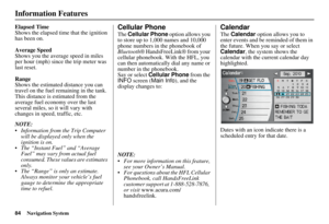 85
85 86
86 87
87 88
88 89
89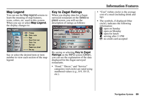 90
90 91
91 92
92 93
93 94
94 95
95 96
96 97
97 98
98 99
99 100
100 101
101 102
102 103
103 104
104 105
105 106
106 107
107 108
108 109
109 110
110 111
111 112
112 113
113 114
114 115
115 116
116 117
117 118
118 119
119 120
120 121
121 122
122 123
123 124
124 125
125 126
126 127
127 128
128 129
129 130
130 131
131 132
132 133
133 134
134 135
135 136
136 137
137 138
138 139
139 140
140 141
141 142
142 143
143 144
144 145
145 146
146 147
147 148
148 149
149 150
150 151
151 152
152 153
153 154
154 155
155 156
156 157
157 158
158 159
159 160
160 161
161 162
162 163
163 164
164 165
165 166
166 167
167 168
168 169
169 170
170 171
171 172
172 173
173 174
174 175
175