Page 10 of 332
8
Familiarisation
Interior
4-wheel drive system with
electronic control *
This system allows the selection of a
transmission mode, according to the drivingconditions.
CVT gearbox
This system offers driving combining a fully automatic mode and a manual mode.
Digital air conditioning
This automatic air conditioning system maintains
the desired comfor t level and adequate air circulation in the passenger compartment.
Audio and communication
systems
These systems benefit from the following
technologies: radio, CD player, USB player, Bluetooth system, satellite navigation system
with colour screen, auxiliary sockets.
AUDIO-TELEMATIC system
122
113
92 28
3
223
AUDIO- CD system
*
Depending on version.
Page 58 of 332

56
Monitoring
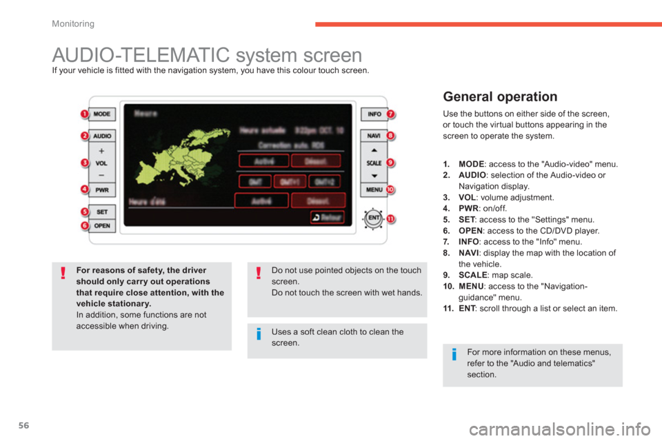
AUDIO-TELEMATIC system screen If your vehicle is fitted with the navigation system, you have this colour touch screen.
General operation
Use the buttons on either side of the screen,
or touch the virtual buttons appearing in the screen to operate the system.
Uses a soft clean cloth to clean thescreen.
Do not use pointed objects on the touch screen.Do not touch the screen with wet hands.
For reasons of safety, the driver should only carry out operationsthat require close attention, with the vehicle stationary.
In addition, some functions are notaccessible when driving.
1.MODE
: access to the "Audio-video" menu.2.AUDIO
: selection of the Audio-video or
Navigation display.3.VOL
: volume adjustment. 4.PWR
: on/off.
5.SET: access to the "Settings" menu. T6.OPEN: access to the CD/DVD player.
7.INFO: access to the "Info" menu. 8.NAVI
: display the map with the location of
the vehicle. 9.SCALE
: map scale. 10. MENU: access to the "Navigation-guidance" menu.11.ENT
: scroll through a list or select an item.T
For more information on these menus, refer to the "Audio and telematics"section.
Page 132 of 332
130
Driving
Reversing camera
Linked with the navigation option, the reversing camera complements the parking sensor system and is activated automatically whenreverse gear is engaged.The colour ima
ge is provided on the navigation screen with indication of the limit of the rear
bumper and of the general direction of the
vehicle.
Page 205 of 332

203
7
Practical information
The fitting of electrical equipment or accessories which are not recommended by CITROËN may resultin a failure of your vehicle's electronicsystem and excessive electrical consumption.
Please note this precaution. Youare advised to contact a CITROËNrepresentative to be shown the range of recommended equipment and accessories.
Installation of radiocommunicationtransmitters
Before installing any after-market radiocommunication transmitter, you cancontact a CITROËN dealer for thespecification of transmitters which can be fitted (frequency, maximum power,aerial position, specific installation requirements), in line with the Vehicle Electromagnetic Compatibility Directive (2004/104/EC).
Depending on the legislation in forcein the country, it may be compulsory to have a high visibility safety vest,warning triangle and spare bulbs andfuses available in the vehicle.
"Multimedia":
semi-integral satellite navigation systems, portable satellite navigation systems, audiosystems, speakers, rear shelf with speakers, hands-free kit, DVD player, mapping update
DVD, speed camera detector, Wi-Fi on board,
230V socket, head-up display, iPhone charger,
rear multimedia carrier...
Page 225 of 332
223
AUDIO-TELEMATIC system
The system is protected in such a way that it will onlyoperate in your vehicle.
01 First steps - Control panel
For safety reasons, the driver must carry out operations
which require prolonged attention while the vehicle is stationary.
When the en
gine is switched off and to prevent
discharging of the battery, the system switches off following the activation of the energy economy mode.
CONTENTS
02 General operation
03 Navigation - Guidance
04 Audio / Video
05 Settings
06 Information
07 USB player p.
p.
p.
p.
p.
p.
p. 224
225
226
236
258
261
264
08 BLUETOOTH
®
streaming - telephone
09 BLUETOOTH
®
telephone p.
p. 269
271
Page 226 of 332
224
01FIRST STEPS
AUDIO: select Audio-video (FM, CD, musicserver, ...) or Navigation (map) display.
V
OL: adjust audio-video volume.
SCALE: change the scale of the map.
P
OWER: audio system on/off (only).
OPEN: opens the screen andgives access to CD/DVD.
A second press closes the
screen.
ENT:
confi rms the choice of the itemselected in the screen.
For certain operations, con
fi rmation is given by pressing the touch screen.
Scroll the map displa
yed or selection of an
item.
Move a fi n
ger over the screen to operate
the system.
Use the buttons o
ffered on the screen.
For safet
y reasons, the driver
must only carry out operations
which require prolonged
attention with the vehicle
stationary.
Mute on/off.
Next or
previous selection for:
- a radio station,
- an audio track
(CD),
- a chapter
(DVD).
Set the audio volume.
Chan
ge the audio-video source (FM, CD, music server, ...).
Page 228 of 332

226
03 NAVIGATION - GUIDANCE
The satellite navigation system guides the driver to the destination
that he has set in accordance with a chosen route.
Initiall
y, it searches for the destination required by the user, thenit calculates the route and fi nally it provides the visual and vocal guidance instructions.
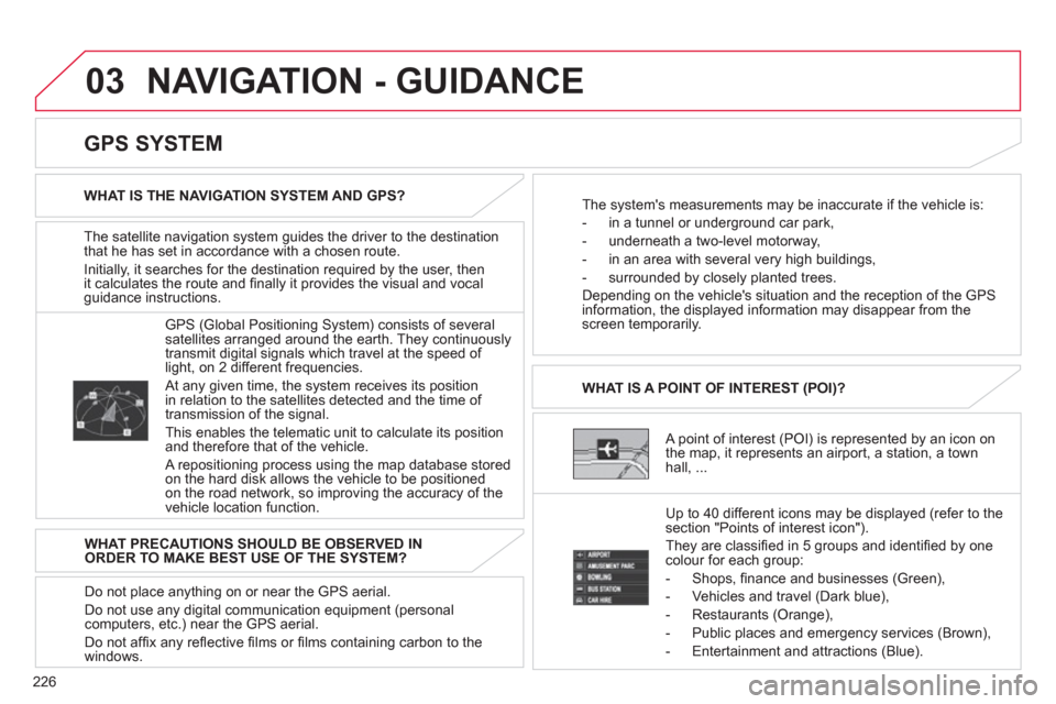
A point of interest (POI) is represented by an icon on
the map, it represents an airport, a station, a town
hall, ... WHAT IS A POINT OF INTEREST
(POI)?
Up to 40 different icons ma
y be displayed (refer to the
section "Points of interest icon").
The
y are classifi ed in 5 groups and identifi ed by onecolour for each group:
-
Shops, fi nance and businesses (Green),
- Vehicles and travel
(Dark blue),
- Restaurants
(Orange),
- Public places and emer
gency services (Brown),
- Entertainment and attractions
(Blue).
GPS
(Global Positioning System) consists of severalsatellites arranged around the earth. They continuouslytransmit digital signals which travel at the speed of
light, on 2 different frequencies.
At any given time, the system receives its position
in relation to the satellites detected and the time of
transmission of the signal.
This enables the telematic unit to calculate its position
and therefore that of the vehicle.
A repositioning process using the map database storedon the hard disk allows the vehicle to be positionedon the road network, so improving the accuracy of the
vehicle location function.
GPS SYSTEM
WHAT IS THE NAVIGATION SYSTEM AND GPS?
The system's measurements may be inaccurate if the vehicle is:
- in a tunnel or under
ground car park,
- underneath a two-level motorwa
y,
-
in an area with several very high buildings,
- surroun
ded by closely planted trees.
Depending on the vehicle's situation and the reception o
f the GPSinformation, the displayed information may disappear from the
screen temporarily.
WHAT PRECAUTIONS SHOULD BE OBSERVED IN
ORDER TO MAKE BEST USE OF THE SYSTEM?
Do not place anything on or near the
GPS aerial.
Do not use an
y digital communication equipment (personalcomputers, etc.) near the GPS aerial.
Do not affi x an
y refl ective fi lms or fi lms containing carbon to the
windows.
Page 237 of 332
235
03
TRAFFIC INFORMATION
Press
Explanation
Result
Press [Route].
Press [Displa
y new route].
The s
ystem offers a detour route (dynamic guidance).
Press [Back] and enter to return to the previous screen.
The s
ystem asks you to confi rm or not the new route.
Press [Yes] to confi rm your choice. The system displays the name of the new route.
Press [No] to not register the route.
During navigation, the system gives you traffi c
information received in real time.
The s
ystem can then suggest a detour route, if dynamic guidance has been activated by pressingMENU, [Navigation settings] then [TMC].
NAVIGATION - GUIDANCE