Page 46 of 312

�4Suggested route:
Appears in bold yellow during route
guidance.
�5/Direction indicator:
Indicates the setting of the map: north al-
ways pointing up or the vehicle’s direction
always pointing up on the display. Touch the
icon to change this setting.
“Setting the map orientation”
(page 3-15)
�6Scale indicator:
Indicates the scale of the map.
Touch the icon to display the scale bar. This
allows the map scale to be adjusted.
“Operating with the touch opera-
tion” (page 3-5)
�7Arrow and distance:
Indicates the distance to the next guide
point and the turning direction at that guide
point.
�8Stored Location (orange) :
Displays the locations that are stored in the
Address Book. Icons can be changed ac-
cording to personal preferences.
�9Avoid Area (green or blue) :
Displays the areas to avoid that are stored
in the Address Book with green or blue
icons. During the route search, the route
guidance is performed by searching for a
route that avoids those areas.
�10Street name:
Displays the name of the street the vehicle
is currently driving on.
�11Traffic indicator:
Displays the reception condition of traffic
information transmitted from the provider.
Green: Reception condition is good.
Gray: Reception condition is not good.
No mark: Subscription to XM NavTraffic�
service is not detected.
Birdview ™ (3D) MAP
Birdview ™ displays the map from an elevated
perspective. In Birdview ™, it is easy to recognize
an image of the route because it provides a pan-
oramic view over a long distance.
INFO:
About the Birdview ™ display
●“Birdview ™” is a registered trademark of
Clarion Co., Ltd.
●The map in Birdview ™ always appears with
the current forward direction facing up.
BUILDING GRAPHICS
In the area where the building graphics are
stored in the map data, the building graphics are
displayed when the map is zoomed in. On the
2D map display, these are called “Building foot-
print graphics”, and on the Birdview™ display,
these are called “3D building graphics”.
The method to look at the map is the same for
the 2D and Birdview™ maps.
NMA0002
Map settings3-3
Page 194 of 312
: Information
: Road work
: Slippery road
: Weather
: Incident
�4Traffic indicator:
Displays the reception condition of traffic
information transmitted from the provider.
Green: Reception condition is good. Gray:
Reception condition is not good. No mark:
Subscription to XM NavTraffic�service is
not detected.
Traffic information display and scale
levels
2D map and Birdview™ Map
320 miles (640 km)
80 miles (160 km)
32 miles (64 km)
8 miles (16 km)
INFO:
The traffic information icons are not displayed on
the map screen when the map scale is set to the
building footprint graphics (2D map) or the 3D
building graphics (Birdview™ map) .
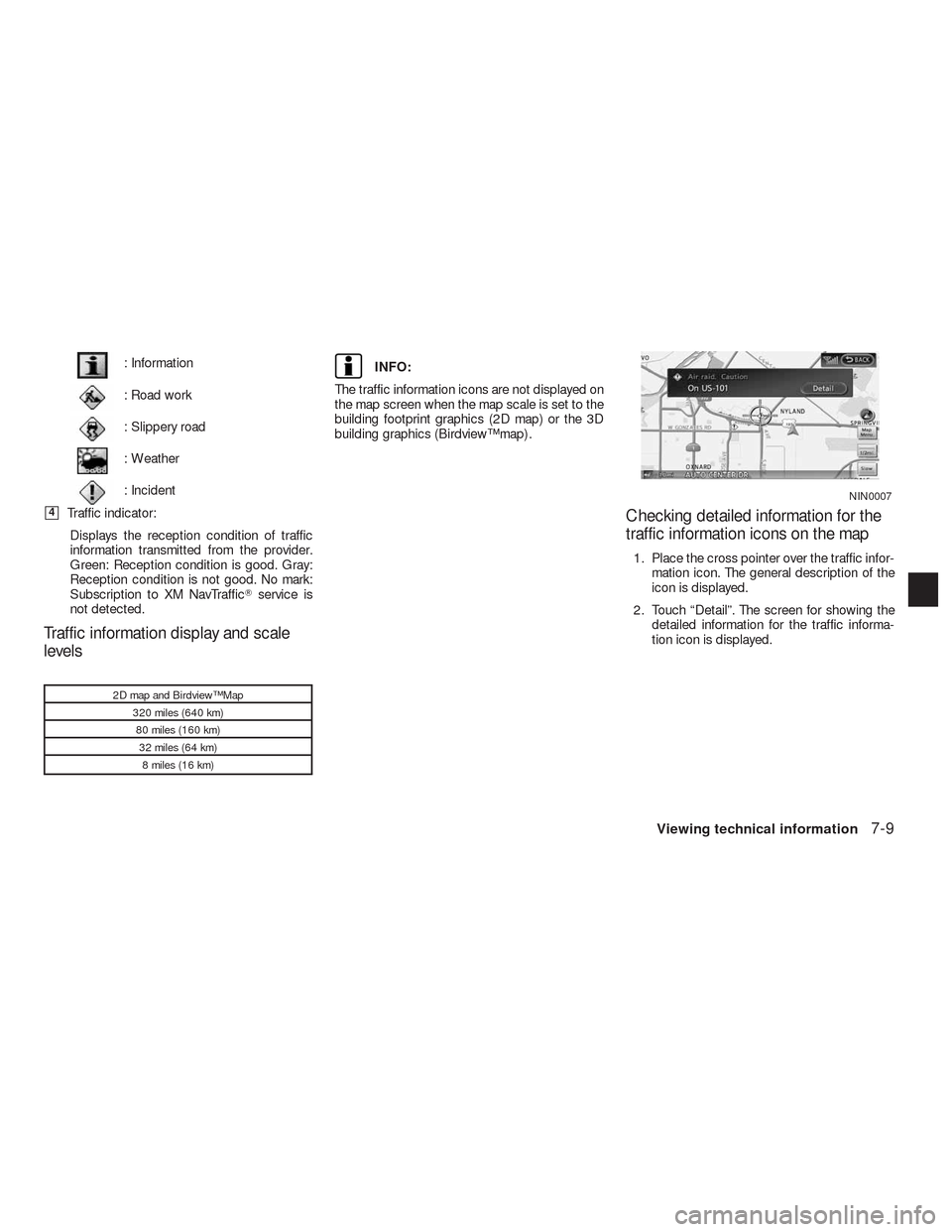
Checking detailed information for the
traffic information icons on the map
1. Place the cross pointer over the traffic infor-
mation icon. The general description of the
icon is displayed.
2. Touch “Detail”. The screen for showing the
detailed information for the traffic informa-
tion icon is displayed.
NIN0007
Viewing technical information7-9
Page 197 of 312

INFO:
The reception condition of the XM�weather in-
formation transmitted from the provider can be
confirmed using the “Weather” indicator on the
upper right side of the screen.
Green: The reception condition is good.
Gray: The reception condition is not good.
No mark: A subscription to the XM Nav-
Weather™ service is not detected.DISPLAYING WEATHER INFORMA-
TION SCREEN
Basic operation
1. Press INFO.
2. Select “Weather Info”.
3. Press BACK to return to the previous
screen. Press MAP to return to the current
location map screen.
Available items:
●Current Weather and Forecasts:
Displays current weather information and
three-day forecasts.
●Warnings and Watches History:
Displays a list of warnings and watches re-
cently detected around the current location.●Weather Map:
Displays the current weather map for the pre-
ferred area.
●Temperature Map:
Displays the current temperature map for the
preferred area.
●Warnings Map:
Displays the current watches/warnings map
for the preferred area.
●Road Condition Map:
Displays the current road condition map for
the preferred area.
Selecting a city
When displaying various weather information
screens by selecting INFO, the range can be
specified for the weather information from
among the current location (local) , destination,
countrywide (nation) or a specified city.
The city can be specified by selecting one from
the list that is displayed.
LNV0591LNV0592
7-12Viewing technical information