2010 MERCEDES-BENZ SLS COUPE stop start
[x] Cancel search: stop startPage 81 of 361
X
Select COMAND ("MB Bluetooth").
X Whe nprompted, enter the passkey on the
Bluetooth ®
device and then on COMAND. System language settings
This function allows you to determine the lan-
guage for the menu displays and the naviga-
tion messages. The language selection
affects the inpu toptions in the editing and
smart speller.
X Select System 0004Settings0004Language .
The list of languages appears. The 0023dot
indicates the current setting.
X To select alanguage: turn002800130029 or slide
001F0013000D.
The selection moves up and down.
X To confirm the language selection: press
0017.
COMAND loads the selected language and
sets it.
i The language selection affects the input
options in the editing and smart speller.
i If you change the system language, the
language for LINGUATRONIC will be also be
changed. If the selected language is not
supported by LINGUATRONIC, "English"
will be selected.
X To cancel language selection: slide
002B0013002C. Reset
i You can reset COMAND to the factory
settings. This includes the deletion of all of
you rpersonal data.
Personal data can include the following:
R phone numbers
R address book entries
R music files in the MUSIC REGISTER
R entries in the destination memory
R station presets Resetting is recommended before selling or
transferring ownership of your vehicle, for
example.
X
Select System0004 Settings0004Reset .
Ap rompt appears asking whethe ryou wish
to reset.
X Select YesorNo.
If you select Yes, a prompt will appear again
asking whether you really wish to reset.
X Select YesorNo.
If you select Yes, a message will be shown.
COMAND is reset and restarted. Navigation system (introduction)
Safety notes
G
Risk of accident
For safety reasons, only enter a new destina-
tion when the vehicle is stationary. You may
otherwise be distracted from the traffic con-
ditions, cause an accident and injure yourself
and others.
COMAND calculates the route to the destina-
tion without taking account of the following,
for example:
R traffic lights
R stop and give way signs
R parking or stopping restrictions
R lane narrowing
R other road and traffic rules and regulations
COMAND may give incorrect driving recom-
mendations if the data on the digital map does
not correspond to the actual conditions. For
example, a route may have been diverted or
the direction of a one-way street may have
changed.
For this reason, you must always observe the
respective road and traffic rules and regula-
tions during your journey. Road and traffic
rules and regulations always have priority
over system driving recommendations. 78
Navigation system (introduction)COMAND APS
BA 197 ECE RE 2010/6a; 1; 2, en-GB
sabbaeu
Version: 3.0.3.6 2010-05-07T14:19:43+02:00 - Seite 78
Page 96 of 361
R
entering a destination from the list of last
destinations
R entering a special destination
R entering a destination using the map
R entering an intermediate stop Entering
adestination by address
i In certain countries, it is no tpossible to
enter an address if the vehicle is travelling
at more than approximately 5 km/h. As
soon as the vehicle speed drops below
about 3km/h, the function is available
again.
When entering an address as the destination,
you have the following options:
R entering the country, town/postcode and
street
R entering the country, town/postcode and
centre
R entering the country, town/postcode,
street and number
R entering the country, town/postcode,
street and junction
R entering the country, town/postcode and
special destination
You can then start route calculation
(Y page 101).
Calling up the address input menu X
Switch to navigation mode and display the
menu system (Y page 82).
X Select Destination0004 Address entry.
The address inpu tmenu appears. It shows
the destination last used for starting route
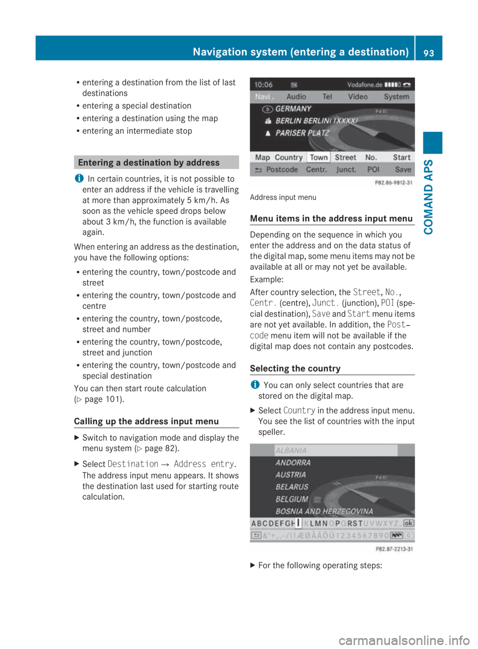
calculation. Address input menu
Menu items in the address input menu
Depending on the sequence in which you
enter the address and on the data status of
the digital map, some menu items may not be
available at all or may not yet be available.
Example:
After country selection, the
Street,No.,
Centr. (centre), Junct.(junction), POI(spe-
cial destination), SaveandStart menu items
are not yet available. In addition, the Post‐
code menu item will not be available if the
digital map does not contain any postcodes.
Selecting the country i
You can only select countries that are
stored on the digital map.
X Select Country in the address input menu.
You see the list of countries with the input
speller. X
For the following operatin gsteps: Navigation syste
m(entering adestination)
93COMAND APS
BA 197 ECE RE 2010/6a; 1; 2, en-GB
sabbaeu Version: 3.0.3.6 2010-05-07T14:19:43+02:00 - Seite 93 Z
Page 104 of 361
X
To cancel the selection: selectBackand
press 0017.
or
X Press the 0001back button next to the
COMAND controller.
X To confirm your selection: press0017.
After you have confirme dyour selection,
the address input menu appears again.
COMAND has accepted the selected junc-
tion and automatically entered it in the
address input menu. You can now start
route calculation.
Starting route calculation i
You cannot start route calculation until all
the necessary address data has been
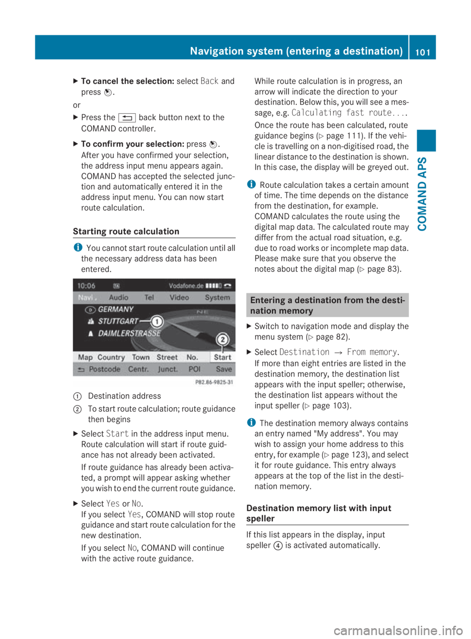
entered. 0001
Destination address
0002 To start route calculation; route guidance
then begins
X Select Startin the address input menu.
Route calculation will start if route guid-
ance has not already been activated.
If route guidance has already been activa-
ted, a prompt will appear asking whether
you wish to end the current route guidance.
X Select YesorNo.
If you select Yes, COMAND will stop route
guidance and start route calculation for the
new destination.
If you select No, COMAND will continue
with the active route guidance. While route calculation is in progress, an
arrow will indicate the direction to your
destination .Below this, you will see a mes-
sage, e.g. Calculating fast route....
Once the route has been calculated, route
guidance begins (Y page 111). If the vehi-
cle is travelling on a non-digitised road, the
linear distance to the destination is shown.
In this case, the display will be greyed out.
i Route calculation takes a certain amount
of time. The time depends on the distance
from the destination, for example.
COMAND calculates the route using the
digital map data. The calculated route may
differ from the actual road situation, e.g.
due to road works or incomplete map data.
Please make sure that you observe the
notes about the digital map (Y page 83). Entering
adestination from the desti-
nation memory
X Switch to navigation mode and display the
menu system (Y page 82).
X Select Destination 0004From memory .
If more than eight entries are listed in the
destination memory, the destination list
appears with the input speller; otherwise,
the destination list appears without the
input spelle r(Ypage 103).
i The destination memory always contains
an entry named "My address". You may
wish to assign your home address to this
entry, for example (Y page 123), and select
it for route guidance. This entry always
appears at the top of the list in the desti-
nation memory.
Destination memory list with input
speller If this list appears in the display, input
speller
0014is activated automatically. Navigation system (entering
adestination)
101COMAND APS
BA 197 ECE RE 2010/6a; 1; 2, en-GB
sabbaeu Version: 3.0.3.6
2010-05-07T14:19:43+02:00 - Seite 101 Z
Page 107 of 361
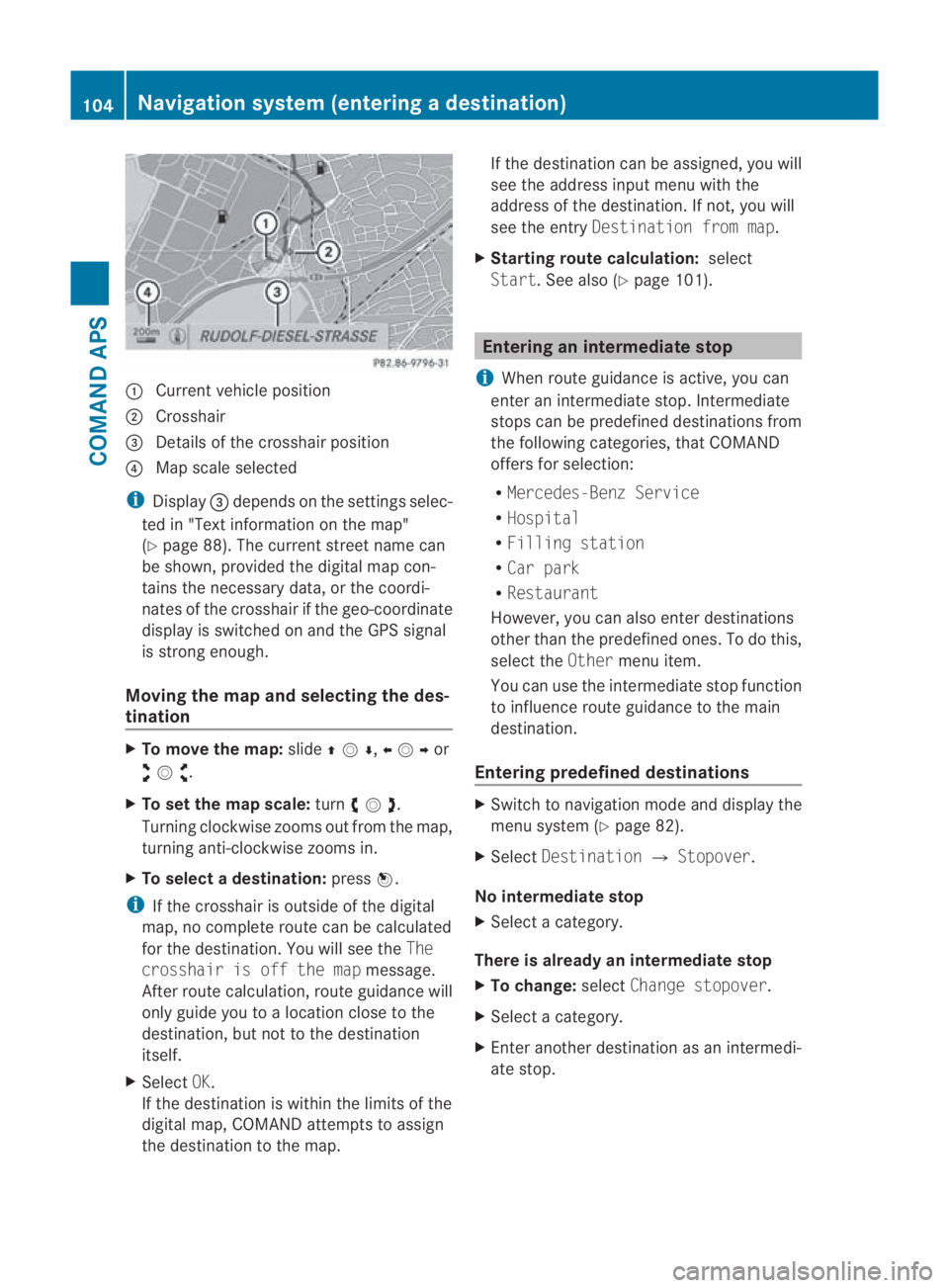
0001
Curren tvehicle position
0002 Crosshair
0015 Details of the crosshair position
0014 Map scale selected
i Display 0015depends on the settings selec-
ted in "Text information on the map"
(Y page 88). The current street name can
be shown, provided the digital map con-
tains the necessary data, or the coordi-
nates of the crosshair if the geo-coordinate
display is switched on and the GPS signal
is strong enough.
Moving the map and selecting the des-
tination X
To move the map: slide001F0013000D ,002B0013002Cor
002A00130027 .
X To set the map scale: turn002800130029 .
Turning clockwise zooms out from the map,
turning anti-clockwise zooms in.
X To select adestination: press0017.
i If the crosshair is outside of the digital
map, no complete route can be calculated
for the destination .You will see the The
crosshair is off the map message.
After route calculation, route guidance will
only guide you to a location close to the
destination, but not to the destination
itself.
X Select OK.
If the destination is within the limits of the
digital map, COMAND attempts to assign
the destination to the map. If the destination can be assigned, you will
see the address input menu with the
address of the destination .Ifnot, you will
see the entry Destination from map.
X Starting route calculation: select
Start.S ee also (Y page 101). Entering an intermediate stop
i When route guidance is active, you can
enter an intermediate stop. Intermediate
stops can be predefined destinations from
the following categories, that COMAND
offers for selection:
R Mercedes-Benz Service
R Hospital
R Filling station
R Car park
R Restaurant
However, you can also enter destinations
other than the predefined ones. To do this,
select the Othermenu item.
You can use the intermediate stop function
to influence route guidance to the main
destination.
Entering predefined destinations X
Switch to navigation mode and display the
menu system (Y page 82).
X Select Destination 0004Stopover.
No intermediate stop
X Select a category.
There is already an intermediate stop
X To change: selectChange stopover.
X Select a category.
X Enter another destination as an intermedi-
ate stop. 104
Navigation system (entering
adestination)COMAND APS
BA 197 ECE RE 2010/6a; 1; 2, en-GB
sabbaeu Version: 3.0.3.6
2010-05-07T14:19:43+02:00 - Seite 104
Page 108 of 361
Selecting
acategory
COMAND first searches in the selected cate-
gory for destinations along the route .Ifthere
are no destinations available there, COMAND
searches for destinations in an area around
the vehicle position.
If COMAND does not find any destinations,
you will see a message to this effect.
X Select OK.
X If necessary, select another category.
If COMAND finds destinations, a list
appears on the right-hand side of the dis-
play.
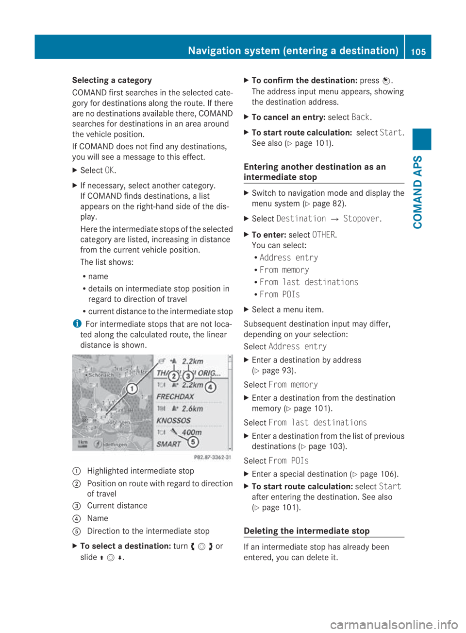
Here the intermediate stops of the selected
category are listed, increasing in distance
from the current vehicle position.
The list shows:
R
name
R details on intermediate stop position in
regard to direction of travel
R current distance to the intermediate stop
i For intermediate stops that are not loca-
ted along the calculated route, the linear
distance is shown. 0001
Highlighted intermediate stop
0002 Position on route with regard to direction
of travel
0015 Current distance
0014 Name
0012 Direction to the intermediate stop
X To selectad estination:turn002800130029or
slide 001F0013000D . X
To confirm the destination: press0017.
The address input menu appears, showing
the destination address.
X To cancel an entry: selectBack.
X To start route calculation: selectStart.
See also (Y page 101).
Entering another destinatio nas an
intermediate stop X
Switch to navigation mode and display the
menu system (Y page 82).
X Select Destination 0004Stopover .
X To enter: selectOTHER.
You can select:
R Address entry
R From memory
R From last destinations
R From POIs
X Select a menu item.
Subsequent destination input may differ,
depending on your selection:
Select Address entry
X Enter a destination by address
(Y page 93).
Select From memory
X Enter a destination from the destination
memory (Y page 101).
Select From last destinations
X Enter a destination from the list of previous
destinations (Y page 103).
Select From POIs
X Enter a special destination (Y page 106).
X To start route calculation: selectStart
after entering the destination. See also
(Y page 101).
Deleting the intermediate stop If an intermediate stop has already been
entered, you can delete it.Navigation system (entering
adestination)
105COMAND APS
BA 197 ECE RE 2010/6a; 1; 2, en-GB
sabbaeu Version: 3.0.3.6
2010-05-07T14:19:43+02:00 - Seite 105 Z
Page 114 of 361
Depending on the map scale selected, spe-
cial destination icons appear on the map.
The scale at which the icons are displayed
on the map varies according to the icon.
You can select the icons tha tCOMAND will
display (Y page 85).
No special destinations are available:
You will see a message to this effect.
i You also see this message if you have
selected the No symbols menu item under
"Map display".
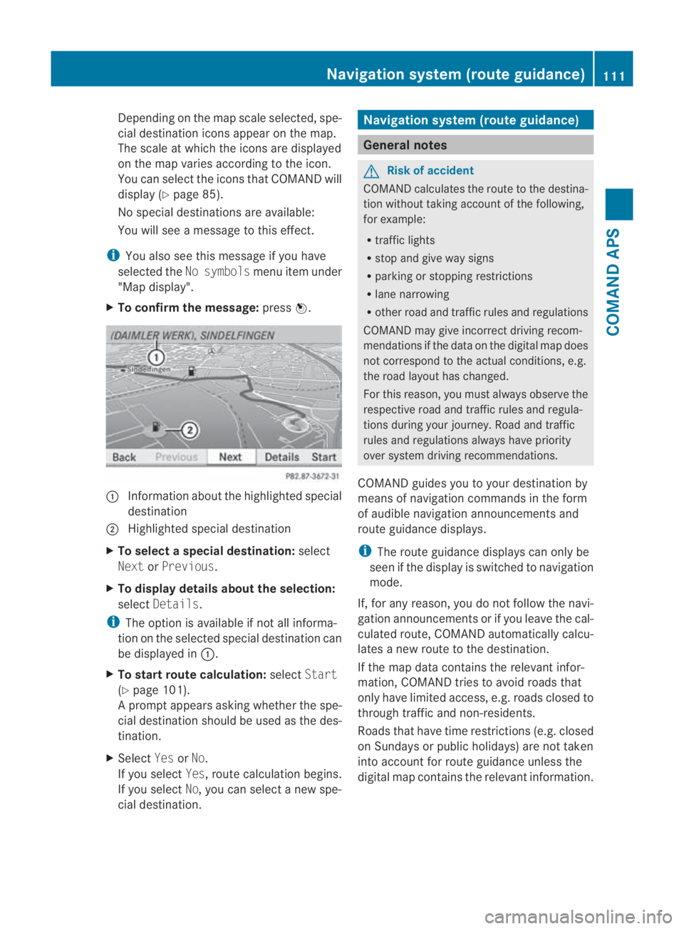
X To confirm the message: press0017. 0001
Information aboutt he highlighted special
destination
0002 Highlighted special destination
X To selectas pecial destination: select
Next orPrevious .
X To display details about the selection:
select Details.
i The option is available if not all informa-
tion on the selected special destination can
be displayed in 0001.
X To start route calculation: selectStart
(Y page 101).
Ap rompt appears asking whethe rthe spe-
cial destination should be used as the des-
tination.
X Select YesorNo.
If you select Yes, route calculation begins.
If you select No, you can select a new spe-
cial destination. Navigation system (route guidance)
General notes
G
Risk of accident
COMAND calculates the route to the destina-
tion without taking account of the following,
for example:
R traffic lights
R stop and give way signs
R parking or stopping restrictions
R lane narrowing
R other road and traffic rules and regulations
COMAND may give incorrect driving recom-
mendations if the data on the digital map does
not correspond to the actual conditions, e.g.
the road layouth as changed.
For this reason, you must always observe the
respective road and traffic rules and regula-
tions during your journey. Road and traffic
rules and regulations always have priority
ove rsystem driving recommendations.
COMAND guides you to your destination by
means of navigation commands in the form
of audible navigation announcements and
route guidance displays.
i The route guidance displays can only be
see nift he display is switched to navigation
mode.
If, for any reason, you do not follow the navi-
gation announcements or if you leave the cal-
culated route, COMAND automatically calcu-
lates a new route to the destination.
If the map data contains the relevant infor-
mation, COMAND tries to avoid roads that
only have limited access, e.g. roads closed to
through traffic and non-residents.
Roads that have time restrictions (e.g. closed
on Sundays or publich olidays) are not taken
into account for route guidance unless the
digital map contains the relevant information. Navigation system (route guidance)
111COMAND APS
BA 197 ECE RE 2010/6a; 1; 2, en-GB
sabbaeu Version: 3.0.3.6 2010-05-07T14:19:43+02:00 - Seite 111 Z
Page 119 of 361
message, a directio
narrow and the distance
to the destination or to the intermediate stop,
if this was configured (Y page 104). The direc-
tional arrow shows the linea rdirection of the
destination. The distance and the estimated
arrival time are displayed in grey in this case.
The route is highlighted blue, starting from
the last recognised street the vehicle was on
before it left the map.
As soon as the vehicle is back on a digitised
road, the distance to the destination appears,
based on the calculated route. Route guid-
ance continues in the usual way.
Route guidance from an off-map loca-
tion to adestination If the vehicle position is outside the area cov-
ered by the digital map, then the vehicle is in
an off-map location. COMAND is also able to
guide you to a destination even from such a
location.
At the start of route guidance you will see the
Off road message, a directio narrow and the
linea rdistance to the destination or to the
intermediate stop, if this has been config-
ured. The arrow shows the compass heading
to the road left last.
The route is highlighted blue fro mthe nearest
road known to the system.
As soon as the vehicle is back on a road
known to the system, route guidance contin-
ues in the usual way.
Off-road during route guidance Due to roadworks, for example, there may be
differences between the data on the digital
map and the actual course of the road.
In such cases, the system will temporarily be
unable to locate the vehicle position on the
digital map and thus considers the vehicle to
be in an off-road position.
You will see the Off roadmessage in the
display, a direction arrow and the distance to
the destination or to the intermediate stop, if
this was configured. As soon as the system can assign the vehicle
position to the map again, route guidance
continues in the usual way. Navigation announcements
i Audible navigation announcements are
muted during a telephone call.
If you have missed an announcement, you can
call up the current announcement at any
time.
X To call up the current announcement:
select 0025in the map display with the menu
system (Y page 83) shown.
X To switch off navigation announce-
ments: during the announcement, press
and hold the 000Bbutton.
You will briefly see the message: The
guidance instructions have been
muted.
X To switch navigation announcements
on again manually: select0025in the map
display with menu system displayed.
or
X Start a new route calculation
(Y page 101).
or
X Switch COMAND on again or start the
engine.
i COMAND switches the navigation
announcements on automatically if it
receives RDS-TMC traffic announcements
during dynamic route guidance
(Y page 119) and starts recalculating the
route.
X To adjust the volume of the announce-
ments: adjust the volume during the auto-
matic announcement (Y page 67).
or
X Call up an announcemen tmanually using
Navi00040025 and adjust the volume.116
Navigation system (route guidance)COMAND APS
BA 197 ECE RE 2010/6a; 1; 2, en-GB
sabbaeu
Version: 3.0.3.6
2010-05-07T14:19:43+02:00 - Seite 116
Page 121 of 361
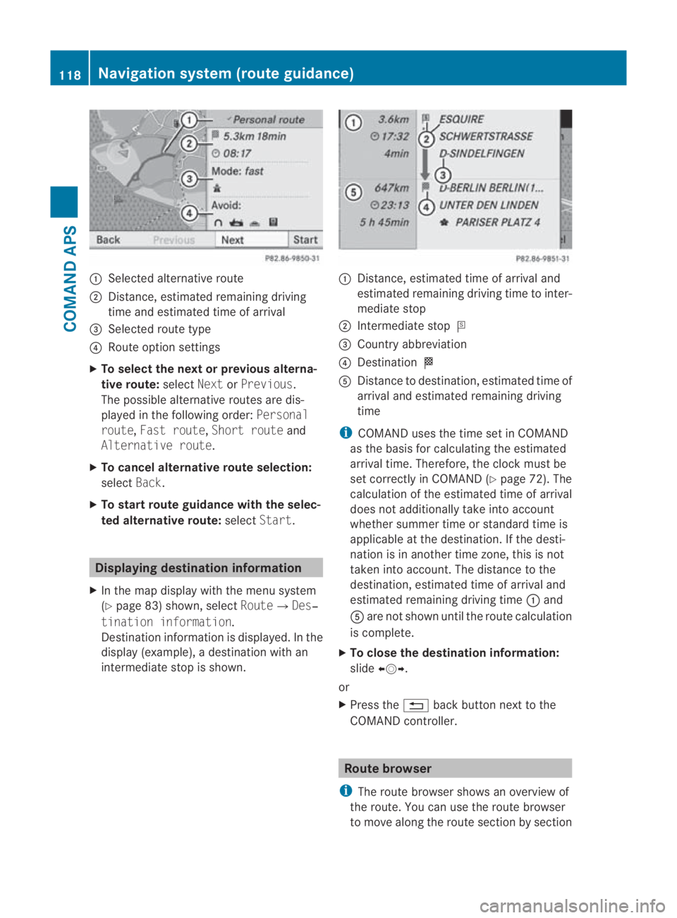
0001
Selected alternative route
0002 Distance, estimated remaining driving
time and estimated time of arrival
0015 Selected route type
0014 Route option settings
X To select the next or previous alterna-
tive route: selectNextorPrevious.
The possible alternative routes are dis-
played in the following order: Personal
route, Fast route, Short route and
Alternative route.
X To cancel alternative route selection:
select Back.
X To start route guidance with the selec-
ted alternative route: selectStart. Displaying destination information
X In the map display with the menu system
(Y page 83) shown, select Route0004Des‐
tination information.
Destination information is displayed .Inthe
display (example), a destination with an
intermediate stop is shown. 0001
Distance, estimated time of arrival and
estimated remaining driving time to inter-
mediate stop
0002 Intermediate stop 000C
0015 Country abbreviation
0014 Destination 000B
0012 Distance to destination, estimated time of
arrival and estimated remaining driving
time
i COMAND uses the time set in COMAND
as the basis for calculating the estimated
arrival time. Therefore, the clock must be
set correctly in COMAND (Y page 72). The
calculation of the estimated time of arrival
does not additionally take into account
whether summer time or standard time is
applicable at the destination. If the desti-
nation is in another time zone, this is not
taken into account. The distance to the
destination, estimated time of arrival and
estimated remaining driving time 0001and
0012 are not shown until the route calculation
is complete.
X To close the destination information:
slide 002B0013002C.
or
X Press the 0001back button next to the
COMAND controller. Route browser
i The route browser shows an overview of
the route. You can use the route browser
to move along the route section by section 118
Navigation system (route guidance)COMAND APS
BA 197 ECE RE 2010/6a; 1; 2, en-GB
sabbaeu
Version: 3.0.3.6 2010-05-07T14:19:43+02:00 - Seite 118