2010 MERCEDES-BENZ S600 navigation system
[x] Cancel search: navigation systemPage 138 of 548

Displaying infoXSelect Info in map view with the menu
system displayed (Y page 102).
The route information appears.
Example illustration: Display with main destinationand stopover
:Distance/estimated time of arrival/
estimated journey time to the stopover
destination
;Stopover destination P=Street, city and state/province?Main destination OADistance/estimated time of arrival/
estimated journey time to the main
destination
iCOMAND uses the time set in COMAND
as the basis for calculating the estimated
arrival time. The clock must be set correctly
in COMAND (Y page 92). The arrival time is
displayed in local vehicle time, based on
the time zone set in the vehicle.
The following data cannot be seen until the
route calculation has been completed:
RDistance to destination
REstimated arrival time
REstimated remaining travel time
If the destination is located within a
partially digitized area, the following data
may differ from the facts:
RDistance to destination
REstimated arrival time
REstimated remaining travel time
Displaying route information
XSelect Route Q Route Info in map view
with the menu system displayed
(Y page 102).
The route information appears.
:Information for highlighted portion of
route
;Highlighted portion of route=Next portion of routeXClosing route info: Select Back and press
W or press back button % in the center
console (Y page 87).
XDisplaying next or previous route
section: Select Next or Previous.
XZooming into or out of route: Select N
or M.
Where am I?
You can display your current position while
route guidance is active as well as when route
guidance has been canceled.
136COMAND navigation system (during route guidance)Control systems
221_AKB; 6; 20, en-USd2ugruen,Version: 2.11.8.12009-09-24T13:28:17+02:00 - Seite 136
Page 139 of 548
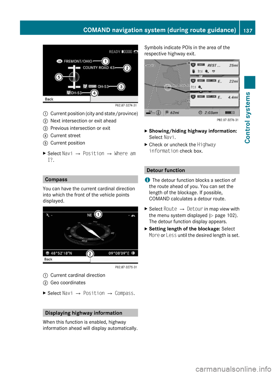
:Current position (city and state/province);Next intersection or exit ahead=Previous intersection or exit?Current streetACurrent positionXSelect Navi Q Position Q Where am
I?.
Compass
You can have the current cardinal direction
into which the front of the vehicle points
displayed.
:Current cardinal direction;Geo coordinatesXSelect Navi Q Position Q Compass.
Displaying highway information
When this function is enabled, highway
information ahead will display automatically.
Symbols indicate POIs in the area of the
respective highway exit.
XShowing/hiding highway information:
Select Navi.
XCheck or uncheck the Highway
information check box.
Detour function
iThe detour function blocks a section of
the route ahead of you. You can set the
length of the blockage. If possible,
COMAND calculates a detour route.
XSelect Route Q Detour in map view with
the menu system displayed (Y page 102).
The detour function display appears.
XSetting length of the blockage: Select
More or Less until the desired length is set.
COMAND navigation system (during route guidance)137Control systems221_AKB; 6; 20, en-USd2ugruen,Version: 2.11.8.12009-09-24T13:28:17+02:00 - Seite 137Z
Page 140 of 548

:Blocked route section;Current vehicle position; the triangle
indicates the vehicle’s direction of travel
=Information about the blocked route
section
iBlocked route section : is always
highlighted in red/white. The information
about blocked route section = shows
which section of the route is blocked and
the length of the blocked section.
XStarting route calculation: Select Start,
see also (Y page 120).
XDeleting blockage: Select Navi Q
Route Q Detour Q Delete.
Alternative Route
You can calculate and display alternative
routes in addition to the route that COMAND
displays automatically. The original route is
displayed in light blue while the alternative
route is dark blue.
XWith the menu system displayed
(Y page 102), select Route Q
Alternative Route.
:Route distance, time, and time of arrival
for the currently selected alternative
route marked in deep blue
;On the Route: Symbols indicate special
parts, such as tunnels, ferries or toll
roads, on the displayed alternative route.
=Mode: Current settings for the displayed
alternative route
Avoid: Symbols of route parts to avoid,
for example tunnels, ferries or toll roads
XDisplaying/selecting other alternative
routes: Select Previous or Next.
XAccepting the currently selected, deep
blue route for route guidance: Select
Start.
COMAND navigation system (real-
time traffic)
Traffic messages
iA subscription to SIRIUS XM Satellite
Radio service provider is required for the
satellite radio reception referred to here.
You can find more information on satellite
radio in chapter “Satellite Radio”
(Y page 170).
COMAND can receive and incorporate traffic
messages via satellite radio into the
navigation system. Traffic report messages
and map symbols can then be viewed in the
COMAND display.
138COMAND navigation system (real-time traffic)Control systems
221_AKB; 6; 20, en-USd2ugruen,Version: 2.11.8.12009-09-24T13:28:17+02:00 - Seite 138
Page 141 of 548
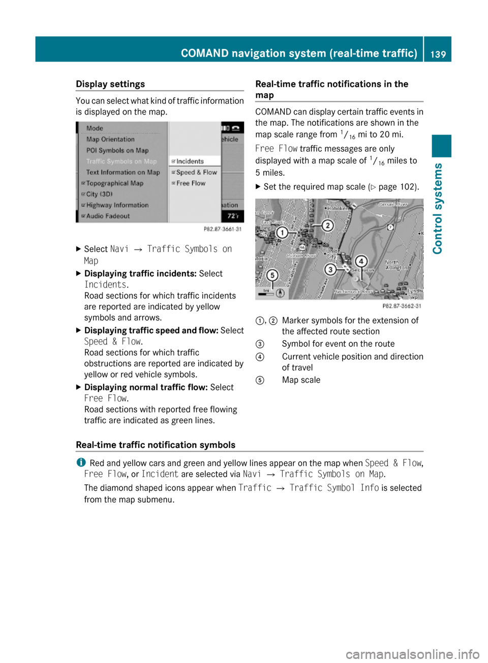
Display settings
You can select what kind of traffic information
is displayed on the map.
XSelect Navi Q Traffic Symbols on
Map
XDisplaying traffic incidents: Select
Incidents.
Road sections for which traffic incidents
are reported are indicated by yellow
symbols and arrows.
XDisplaying traffic speed and flow: Select
Speed & Flow.
Road sections for which traffic
obstructions are reported are indicated by
yellow or red vehicle symbols.
XDisplaying normal traffic flow: Select
Free Flow.
Road sections with reported free flowing
traffic are indicated as green lines.
Real-time traffic notifications in the
map
COMAND can display certain traffic events in
the map. The notifications are shown in the
map scale range from 1/16 mi to 20 mi.
Free Flow traffic messages are only
displayed with a map scale of 1/16 miles to
5 miles.
XSet the required map scale (Y page 102).1, 2Marker symbols for the extension of
the affected route section
3Symbol for event on the route4Current vehicle position and direction
of travel
AMap scale
Real-time traffic notification symbols
iRed and yellow cars and green and yellow lines appear on the map when Speed & Flow,
Free Flow, or Incident are selected via Navi Q Traffic Symbols on Map.
The diamond shaped icons appear when Traffic Q Traffic Symbol Info is selected
from the map submenu.
COMAND navigation system (real-time traffic)139Control systems221_AKB; 6; 20, en-USd2ugruen,Version: 2.11.8.12009-09-24T13:28:17+02:00 - Seite 139Z
Page 142 of 548
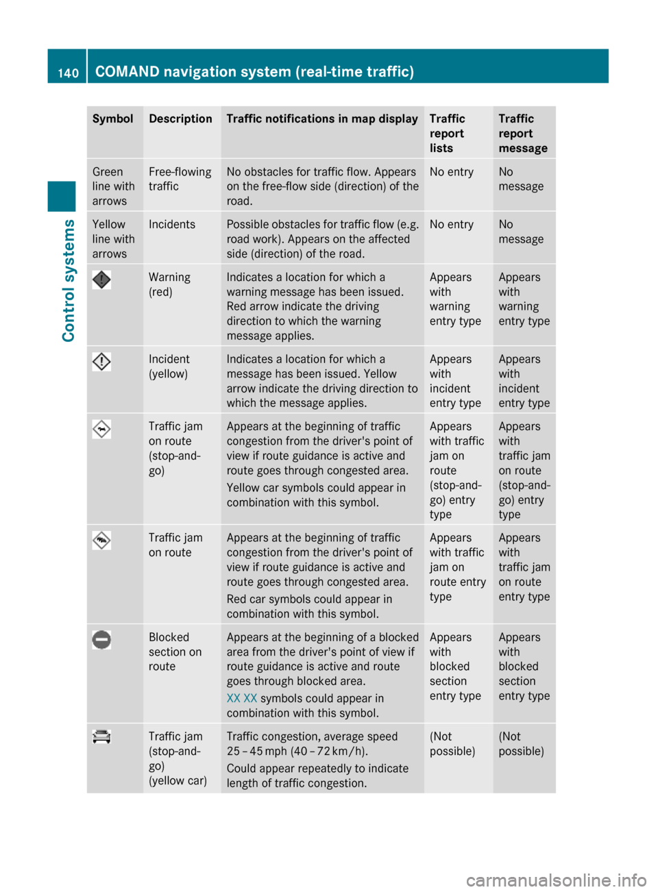
SymbolDescriptionTraffic notifications in map displayTraffic
report
lists
Traffic
report
message
Green
line with
arrows
Free-flowing
traffic
No obstacles for traffic flow. Appears
on the free-flow side (direction) of the
road.
No entryNo
message
Yellow
line with
arrows
IncidentsPossible obstacles for traffic flow (e.g.
road work). Appears on the affected
side (direction) of the road.
No entryNo
message
Warning
(red)
Indicates a location for which a
warning message has been issued.
Red arrow indicate the driving
direction to which the warning
message applies.
Appears
with
warning
entry type
Appears
with
warning
entry type
Incident
(yellow)
Indicates a location for which a
message has been issued. Yellow
arrow indicate the driving direction to
which the message applies.
Appears
with
incident
entry type
Appears
with
incident
entry type
Traffic jam
on route
(stop-and-
go)
Appears at the beginning of traffic
congestion from the driver's point of
view if route guidance is active and
route goes through congested area.
Yellow car symbols could appear in
combination with this symbol.
Appears
with traffic
jam on
route
(stop-and-
go) entry
type
Appears
with
traffic jam
on route
(stop-and-
go) entry
type
Traffic jam
on route
Appears at the beginning of traffic
congestion from the driver's point of
view if route guidance is active and
route goes through congested area.
Red car symbols could appear in
combination with this symbol.
Appears
with traffic
jam on
route entry
type
Appears
with
traffic jam
on route
entry type
Blocked
section on
route
Appears at the beginning of a blocked
area from the driver's point of view if
route guidance is active and route
goes through blocked area.
XX XX symbols could appear in
combination with this symbol.
Appears
with
blocked
section
entry type
Appears
with
blocked
section
entry type
Traffic jam
(stop-and-
go)
(yellow car)
Traffic congestion, average speed
25 – 45 mph (40 – 72 km/h).
Could appear repeatedly to indicate
length of traffic congestion.
(Not
possible)
(Not
possible)
140COMAND navigation system (real-time traffic)Control systems
221_AKB; 6; 20, en-USd2ugruen,Version: 2.11.8.12009-09-24T13:28:17+02:00 - Seite 140
Page 143 of 548

SymbolDescriptionTraffic notifications in map displayTraffic
report
lists
Traffic
report
message
Traffic jam
(red car)
Traffic congestion, average speed
5 – 20 mph (8 – 32 km/h).
Could appear repeatedly to indicate
length of traffic congestion.
(Not
possible)
(Not
possible)
XXXXBlocked
section
Road impassable.
Could appear repeatedly to indicate
length of blocked area
(Not
possible)
(Not
possible)
Displaying real-time traffic reportsXIf necessary, switch to navigation mode
and show the menu system (Y page 102).
XSelect Traffic.
COMAND searches for satellite radio
channels sending traffic messages.
The message No traffic reports are
currently available for this area.
may appear for the following reasons:RMessages were not yet received.
RThere are no messages available.
XCancelling the search: Select Cancel.XClosing the message: Select OK
If there are traffic reports, you will see a list
or a submenu, depending on whether route
guidance is active or not.
iA traffic message may also concern an
area or region rather than a road, e.g.
impaired visibility due to fog.
List when route guidance is not active
The list shows all the roads, areas or regions
for which messages are available.
1Country, state or province indicator
(optional)
2Road concernedXDisplaying a traffic message: Select an
item from the list.
The traffic message appears, see “Example
of a traffic message” (Y page 142).
XClosing the list: Slide XVY once or
repeatedly.
XDisplaying traffic symbol information:
Select Traffic Symbol Info
(Y page 142).
COMAND navigation system (real-time traffic)141Control systems221_AKB; 6; 20, en-USd2ugruen,Version: 2.11.8.12009-09-24T13:28:17+02:00 - Seite 141Z
Page 144 of 548
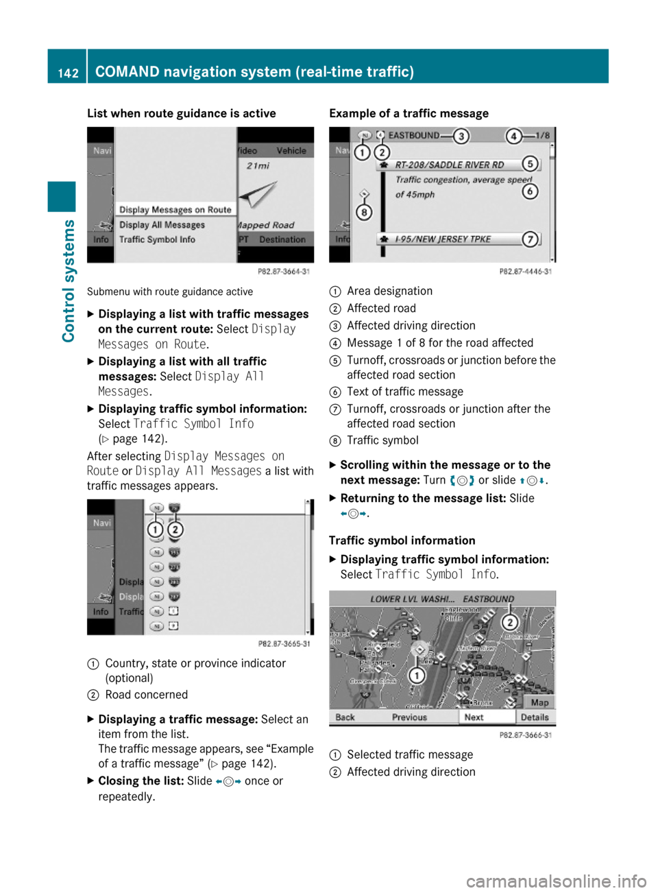
List when route guidance is active
Submenu with route guidance active
XDisplaying a list with traffic messages
on the current route: Select Display
Messages on Route.
XDisplaying a list with all traffic
messages: Select Display All
Messages.
XDisplaying traffic symbol information:
Select Traffic Symbol Info
(Y page 142).
After selecting Display Messages on
Route or Display All Messages a list with
traffic messages appears.
1Country, state or province indicator
(optional)
2Road concernedXDisplaying a traffic message: Select an
item from the list.
The traffic message appears, see “Example
of a traffic message” (Y page 142).
XClosing the list: Slide XVY once or
repeatedly.
Example of a traffic message1Area designation2Affected road3Affected driving direction4Message 1 of 8 for the road affected5Turnoff, crossroads or junction before the
affected road section
6Text of traffic messageCTurnoff, crossroads or junction after the
affected road section
DTraffic symbolXScrolling within the message or to the
next message: Turn cVd or slide ZVÆ.
XReturning to the message list: Slide
XVY.
Traffic symbol information
XDisplaying traffic symbol information:
Select Traffic Symbol Info.1Selected traffic message2Affected driving direction142COMAND navigation system (real-time traffic)Control systems
221_AKB; 6; 20, en-USd2ugruen,Version: 2.11.8.12009-09-24T13:28:17+02:00 - Seite 142
Page 145 of 548
XBack to list: Select Back.XDisplaying previous or next traffic
message: Select Previous or Next.
XDisplaying details for selected traffic
message: Select Details.
XSwitching to map view: Select Map.
COMAND navigation system
(destination memory)
My address
iThe destination memory always contains
an entry called My Address. You can save
your home address, for example, under this
entry.
Assigning your address for the first
time or changing your own address
Assigning and/or changing your own
address
XSelect Navi Q Destination Q From
Memory.
Depending on the number of entries in the
destination memory, you will see the
destination memory list with or without
predictive speller.
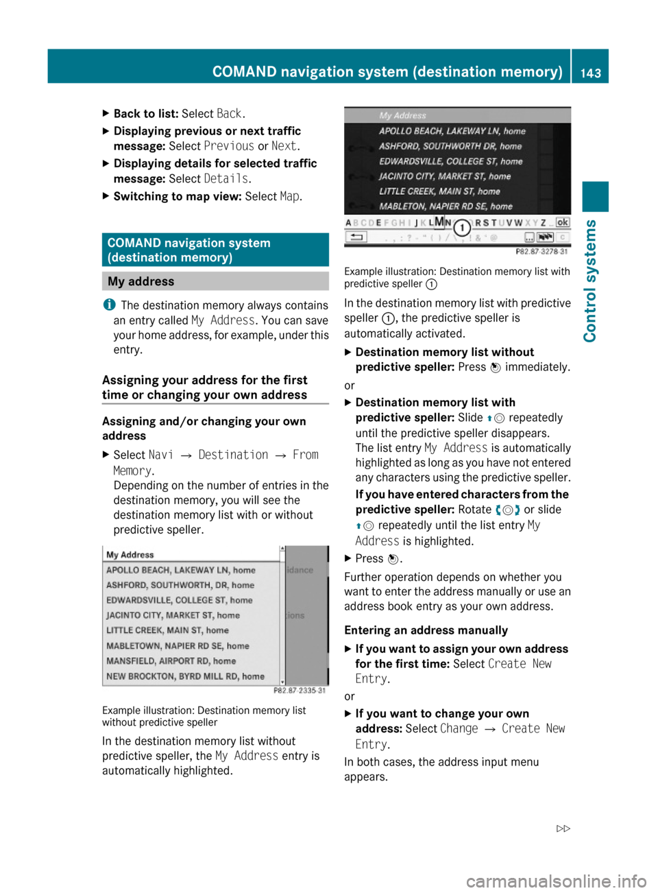
Example illustration: Destination memory listwithout predictive speller
In the destination memory list without
predictive speller, the My Address entry is
automatically highlighted.
Example illustration: Destination memory list withpredictive speller :
In the destination memory list with predictive
speller :, the predictive speller is
automatically activated.
XDestination memory list without
predictive speller: Press W immediately.
or
XDestination memory list with
predictive speller: Slide ZV repeatedly
until the predictive speller disappears.
The list entry My Address is automatically
highlighted as long as you have not entered
any characters using the predictive speller.
If you have entered characters from the
predictive speller: Rotate cVd or slide
ZV repeatedly until the list entry My
Address is highlighted.
XPress W.
Further operation depends on whether you
want to enter the address manually or use an
address book entry as your own address.
Entering an address manually
XIf you want to assign your own address
for the first time: Select Create New
Entry.
or
XIf you want to change your own
address: Select Change Q Create New
Entry.
In both cases, the address input menu
appears.
COMAND navigation system (destination memory)143Control systems221_AKB; 6; 20, en-USd2ugruen,Version: 2.11.8.12009-09-24T13:28:17+02:00 - Seite 143Z