2010 Acura TL lock
[x] Cancel search: lockPage 122 of 174

System Initialization
122 Navigation System
System Initialization
If for any reason you lose power to
the navigation system (e.g., the battery
was disconnected), the navigation
system will require initialization. Once
completed, your system will be ready
to use.
This initialization requires the
following:
• Entry of the 5-digit anti-theft security
code to “unlock” the audio and
navigation system.
• GPS initialization (may not be needed depending on the length of
time the system was without power).
(See GPS Initialization o n p a g e 1 2 2 . )
• Map matching to align the GPS coordinates to a place on the map
(displays current street at the bottom
of the map). (See Map Matching on
page 123 .)
Entering the Security Code
If the battery goes dead or is
disconnected for any reason, you will
have to enter a security code for the
audio and navigation system before you
can use it again.
When you purchased the vehicle,
you should have received one card
containing the navigation system’s
security code and serial number. Keep
this card in a safe place in case you
need the code. If you lose the card, you
must obtain the security code from your
dealer.
Enter the 5-digit security code in
accordance with the owner’s manual
for your vehicle. If you do not enter the
security code, the navigation and audio
voice will not function.
NOTE:
The anti-theft security code is
unrelated to your optional navigation
system PIN (for Address Book or Home
Address) .
GPS Initialization
Depending on the length of time the
battery was disconnected, your system
may require GPS initialization. If it
does, the following screen appears:
If this procedure is not necessary,
the system proceeds directly to the
Disclaimer screen (see page 18 ).
During initialization, the system
searches for all available GPS satellites
and obtains their orbital information.
During this procedure, the vehicle
should be out in the open with a clear
view of the sky.
2010 TL
Page 124 of 174

System Limitations
124 Navigation System
Also, depending on your current view
of the sky and the position of the
satellites, the elevation may be shown
incorrectly.
You may also notice some delay of the
vehicle position icon at intersections;
this is normal.
GPS Reception Issues
The signals received from the GPS
satellites are extremely weak (less
than a millionth of the strength of
a local FM station) and require an
unobstructed view of sky. The signal
can easily be interrupted or interfered
with by the following:
• Aftermarket metallic window tint
above or to the sides of the GPS
antenna (located on the back of the
navigation display)
• Cell phones, PDAs, or other electronic devices docked in a cradle
or lying loose on the dashboard
• Remote starters or “hidden” vehicle tracking systems mounted near the
navigation unit • Other aftermarket audio electronic
devices mounted near the navigation
unit
• Trees, tall buildings, freeway overpasses, tunnels, or overhead
electrical power wires
Although the system will direct you
to your desired destination, it may not
always generate what you consider to
be the most direct route. Try changing
the method of routing. See Changing
the Routing Method on page 52 . You may
also have Unver ifi ed Area Routing set
to OFF. See Unverifi ed Area Routing on
page 10 2 .
Additionally, the mapping database
contains verifi ed and unverifi ed maps.
See Map Overview on page 6 . A
Disclaimer screen will warn you if
your route includes unverifi ed streets.
Unver ifi ed streets may be missing from
the map, in the wrong location, or have
an incorrect name or address range.
Exercise additional caution when
driving in these unverifi ed areas. The destination icon shows the
approximate location of the destination.
This occurs because a city block can
have as many as 100 possible addresses
(for example, the 1400 block is followed
by the 1500 block) Since most cities
use only a portion of the 100 possible
addresses (for example, in the 1400
block, the addresses may only go up to
1425 before the 1500 block starts), the
address 1425 will be shown a quarter of
the way down the block by the system
instead of at the end of the block where
the destination is actually located.
You may fi
nd that the system
occasionally reboots. This is indicated
by the display returning to the globe
screen. A reboot can be caused by a
number of things, such as extreme
temperatures or shock from bumpy
roads. It does not necessarily indicate
a problem that requires service. If this
happens frequently, please see your
dealer.
System Limitations
2010 TL
Page 139 of 174

Coverage Areas
Navigation System139
La Rivìere-du-Nord
Prévost
St-Colomban
St-Hippolyte
St-Jèrôme
Ste-Sophie
La Vallee-du-Richelieu Beloeil
Caringnan
Chambly
McMasterville
Mont-St-Hilaire
Otterburn Park
St-Antoine-sur-Richelieu
St-Basile-le-Grand
St-Charles-sur-Richelieu
St-Denis-sur-Richelieu
St-Jean-Baptiste
St-Marc-sur-Richelieu
St-Mathieu-de-Beloeil
LaJemmerais Calixa-Lavallée
Contrecoeur
St-Amable
Ste-Julie
Va r e n n e s
Ve r c h è r e s
Laval Laval Le-Haut-Richelieu
Henryville
Lacolle
Mont-St-Grégoire
Noyan
St-Alexandre
St-Blaise-sur-Richelieu
St-Georges-de-Clarenceville
St-Jean-sur-Richelieu
St-Paul-de-L’Île-aux-Noix
St-Sébastien
St-Valentin
Ste-Anne-de-Sabreviois
Ste-Brigide-D’Iberville
Ve n i s e - e n - Q u é b e c
Le Haut-St-Laurent Dundee
Elgin
Franklin
Godmanchester
Havelock
Hinchinbrooke
Howick
Huntingdon
Ormstown
St-Anicet
St-Chrysostome
Ste-Barbe
Très- St- Sac rement Les-Jardins-De-Napierville
Hemmingford
Hemmingford Village
Napierville
St-Bernard-de-Lacolle
St-Cyprien-de-Châteauguay
St-Édouard
St-Jacques-le-Mineur
St-Michel
St-Patrice-de-Sherrington
St-Rémi
Les Laurentides Amherst
Arundel
Barkmere
Brèbeuf
Huberdeau
La Conception
La Minerve
Labelle
Lac-Supèrieur
Lantier
Mont-Tremblant
Montcalm
St-Faustin-Lac-Carrè
Ste-Agathe-des-Monts
Ste-Lucie-des-Laurentides
Va l - D a v i d
Va l - d e s - L a c s
Va l - M o r i n
2010 TL
Page 149 of 174

Frequently Asked Questions
Navigation System149
Guidance, Routing
Problem Solution
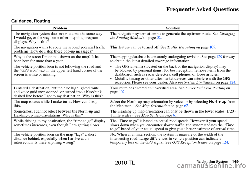
The navigation system does not route me the same way
I would go, or the way some other mapping program
displays. Why is this? The navigation system attempts to generate the optimum route. See
Changing
the Routing Method o n p a g e 5 2 .
The navigation wants to route me around potential traffi c
problems. How do I stop these pop-up messages? This feature can be turned off. See
Traffi c Rerouting on page 109 .
Why is the street I’m on not shown on the map? It has
been here for more than a year. The mapping database is constantly undergoing revision. See page
129 for ways
to obtain the latest detailed coverage information.
The vehicle position icon is not following the road and
the “GPS icon” text in the upper left hand corner of the
screen is white or missing. • The GPS antenna (located on the back of the navigation display) may
be blocked by personal items. For best reception, remove items from the
dashboard, such as radar detectors, cell phones, or loose articles.
• Metallic tinting or other aftermarket devices can interfere with the GPS reception. Please see your dealer. Also see System Limitations on page 124 .
I entered a destination, but the blue highlighted route
and voice guidance stopped, or turned into a blue/pink
dashed line before I got to my destination. Why is this? Your route has entered an unverifi
ed area. See Unverifi ed Area Routing on
page 102 .
The map rotates while I make turns. How can I stop
this? Select the North-up map orientation by voice, or by selecting
North-up from
the Map menu. See Map Orientation on page 62 .
Sometimes, I cannot select between the North-up and
Heading-up map orientations. Why is this? The Heading-up map orientation can only be shown in the lower scales (1/20 -
1 mile scales). See
Map Scale on page 61 .
While driving to my destination, the “time to go” display
sometimes increases, even though I am getting closer. The “Time to go” is based on actual road speeds. However if your speed
slows down when you encounter slower traffi
c, the system updates the “Time
to go” based of your actual speed to give you a better estimate of arrival time.
The vehicle position icon on the map “lags” a short
distance behind, especially when I arrive at an
intersection. Is there anything wrong? No. When at an intersection, the system is unaware of the width of the
intersecting road. Large differences in vehicle position can indicate a
temporary loss of the GPS signal. See
GPS Reception Issues on page 124 .
2010 TL
Page 152 of 174

Frequently Asked Questions
152 Navigation System
Display, Accessories
Problem Solution
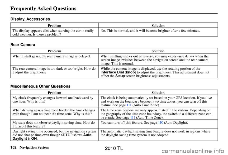
The display appears dim when starting the car in really
cold weather. Is there a problem? No. This is normal, and it will become brighter after a few minutes.
Rear Camera
Problem
Solution
When I shift gears, the rear camera image is delayed. When shifting into or out of reverse, you may experience delays when the screen image switches between the navigation screen and the rear camera
image. This is normal.
The rear camera image is too dark or too bright. How do
I adjust the brightness? While the camera image is displayed, use the rotating portion of the
Interface Dial
(knob ) to adjust the brightness. This adjustment does not
affect the Setup screen brightness adjustments.
Miscellaneous Other Questions
Problem Solution
My clock frequently changes forward and backward by
one hour. Why is this? The clock is being automatically set based on your GPS location. If you live
and work on the boundary between two time zones, you can turn off this
feature. See page
111 (Auto Time Zone).
When driving near a time zone border, the time changes
even though I am not near the time zone. Why is this? The time zone borders are only approximated in the system. Depending on
the geography of the time zone boundary, the switch to a different zone can
be erratic. See page 111 (Auto Time Zone).
My state does not observe daylight saving time. How do
I turn off this feature? You can turn off this feature. See page
110 (Auto Daylight).
Daylight saving time occurred, but the navigation system
did not change time even though SETUP shows Auto
Daylight is ON. The automatic daylight saving time feature does not work in regions where
the daylight saving time system is not adopted.
2010 TL
Page 153 of 174

Frequently Asked Questions
Navigation System153
Problem Solution
The navigation system automatic daylight time feature is
not switching the navigation system clock on the correct
dates. Why is this? 1) Go to the Clock adjustment
screen in SETUP and ensure that Auto
Daylight is ON.
2) The automatic daylight saving time feature does not work in regions where the daylight saving time system is not adopted.
For more information, see Clock Adjustment on page 110 .
The navigation system clock switched by one hour for no
apparent reason. What can cause this? You may be driving near a time zone boundary (see Auto Daylight
o n p a g e 110 ) .
See page 111 (Auto Time Zone) for more information.
My battery was disconnected or went dead, and the
navigation system is asking for a code. Where do I fi nd
this code? There should be a card in the glove box with the anti-theft code for the
navigation/audio system. This card contains the 5-digit security code and
serial number. If you cannot fi
nd it, your dealer can help you out.
I speak a language other than English. Are there any
other languages available for the system? Besides English, you may select French or Spanish for your language setting.
However, messages will continue to be in English.
2010 TL
Page 170 of 174

INDEX
170 Navigation System
A
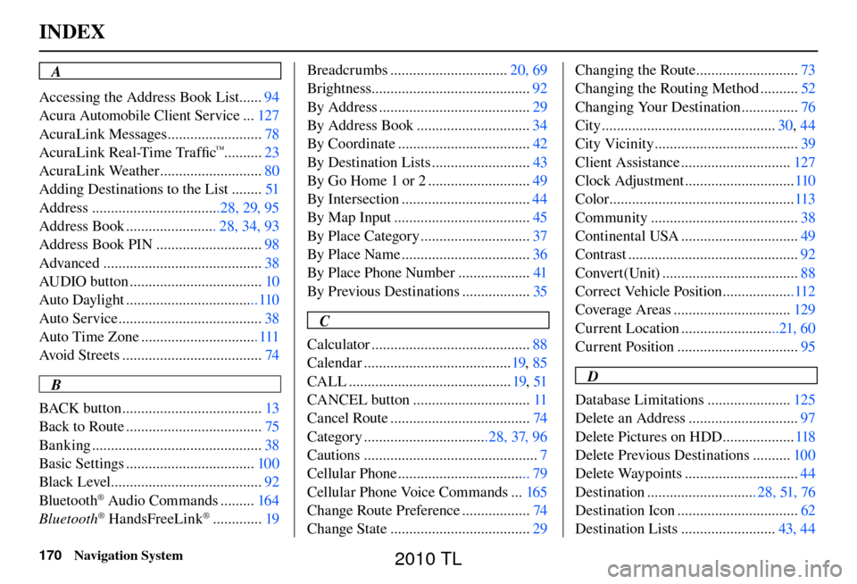
Accessing the Address Book List ...... 94
Acura Automobile Client Service ... 127
AcuraLink Messages ......................... 78
AcuraLink Real-Time Traffi c
™..........23
AcuraLink Weather ........................... 80
Adding Destinations to the List ........ 51
Address ..................................28, 29, 95
Address Book ........................ 28, 34, 93
Address Book PIN ............................ 98
Advanced .......................................... 38
AUDIO button ................................... 10
Auto Daylight ...................................110
Auto Service ...................................... 38
Auto Time Zone ............................... 111
Avoid Streets ..................................... 74
B
BACK button ..................................... 13
Back to Route .................................... 75
Banking ............................................. 38
Basic Settings .................................. 100
Black Level ........................................ 92
Bluetooth
® Audio Commands ......... 164
Bluetooth® HandsFreeLink® ............. 19Breadcrumbs ...............................
20, 69
Brightness.......................................... 92
By Address ........................................ 29
By Address Book .............................. 34
By Coordinate ................................... 42
By Destination Lists .......................... 43
By Go Home 1 or 2 ........................... 49
By Intersection .................................. 44
By Map Input .................................... 45
By Place Category ............................. 37
By Place Name .................................. 36
By Place Phone Number ................... 41
By Previous Destinations .................. 35
C
Calculator .......................................... 88
Calendar ....................................... 19, 85
CALL ........................................... 19, 51
CANCEL button ............................... 11
Cancel Route ..................................... 74
Category .................................28, 37, 96
Cautions .............................................. 7
Cellular Phone ................................... 79
Cellular Phone Voice Commands ... 165
Change Route Preference .................. 74
Change State ..................................... 29Changing the Route ...........................
73
Changing the Routing Method .......... 52
Changing Your Destination ............... 76
City .............................................. 30, 44
City Vicinity ...................................... 39
Client Assistance ............................. 127
Clock Adjustment ............................. 110
Color ................................................. 113
Community ....................................... 38
Continental USA ............................... 49
Contrast ............................................. 92
Convert(Unit) .................................... 88
Correct Vehicle Position ...................112
Coverage Areas ............................... 129
Current Location ..........................21, 60
Current Position ................................ 95
D
Database Limitations ...................... 125
Delete an Address ............................. 97
Delete Pictures on HDD ................... 118
Delete Previous Destinations .......... 100
Delete Waypoints .............................. 44
Destination ............................. 28, 51, 76
Destination Icon ................................ 62
Destination Lists ......................... 43, 44
2010 TL