2010 Acura MDX gas
[x] Cancel search: gasPage 20 of 184

20Navigation System
Getting Started
Map Screen Legend
: Par k
: Hospital
: Shopping Mall
: Golf Course: Airport/Business
: Water Area
: Cemetery
: University
Traffic Status Indicator
(see page
23.)
Vehicle Position (see page64)
(Use voice command “Display
current location” or use the
Interface Dial to show current
location.)
Current Map Scale
(see page 66)
Message Icon (see page80)
Indicates that you have an
AcuraLink message.
Warning Icon
Indicates that there are weather
warnings. To check the warning
list, see page 85.
Current Street
(see page
6)
Map Scale Adjustment
(Mile or km per half-inch appears only
when you zoom in or out by rotating the
Interface Dial knob .)
NOTE:
See Map Legend in the Map Information
on the Map menu for further explanation.
No Entry Icon
GPS Signal Strength
: Best Reception
: Good Reception
(Missing): Poor/No ReceptionMap Orientation
(see page 63)
Map Menu
(see page 58)
(Push in on the Interface Dial to view.)
Breadcrumbs
(see
Off-road Tracking on
page 71) Streets
(see Map Overview on page6)
: Freeways
: State Routes
: Verified Streets
: Unverified Streets
: One-way Streets (see page 67)
(1/20 mile scale only)
Landmark Icon - Generic (see page67)
Grocery Store
Hotel/Lodging
Gas Station
Hospital
Post Office
Restaurant
Acura Dealer
Honda Dealer
AT M
School
Parking Lot
Parking Garage
Freeway Exit Information
NOTE:
If you move the
Interface Dial over an area (map features
shown above), the name is displayed at the top of the screen.
North-up Heading-up
Map Features
2010 MDX
Page 39 of 184

Navigation System39
Entering a Destination
Auto Service LodgingShoppingAcura Dealers*1Auto Repair & Maintenance Bed & Breakfast Resort All Shopping*3 Office Supplies/Electronics
Acura Roadside Assistance Car Wash & Detailing H otel/MotelAccessories/Jewelry Pharmacy/Drug Store
Honda Dealers*1 Motorcycle Dealers
LeisureAuto Parts & Electronics Pet Food/Supplies
Gas Station*1 Other Car Dealers Amusement Park Museum Books/Music/Video Sewing/Linen
Hydrogen Station Roadside Assistance Golf CoursePark/Recreation Area Clothing Shoes/Bags
Auto Parts & Electronics Historical Monument Performing Arts Groceries Sporting Goods
BankingMarinaSports Complex Home Improvement Toys/Arts/Crafts
ATM*1 Check Cashing/Money Transfer Movie Theater Tourist Attraction Mall/Department Store
Bank Currency Exchange
Restaurant Travel
CommunityAll Types*1*2 IndianAirport Parking Lot
Business Higher Education All Types (Zagat Only) Italian Automobile Club Rental Car Agency
City Hall Library AmericanJapaneseBed & Breakfast Resort
Civic/Community Center Post Office CalifornianKoreanBus Station Rest Area
Convention/Exhibition Center School ChineseMexicanCamping Ski Area
Court House Café/Coffee Shop PizzaCommuter Rail Station Tourist Attraction
EmergencyContinentalSeafoodFerry Terminal Tourist Information
Acura Roadside Assistance Roadside Assistan ceFast Food ThaiHotel/Motel Train Station
Hospital*1 Veterinarian FrenchVegetarianNamed Place Travel Agency
Police Station GermanVietnamesePark & Ride Truck Stop/Plaza
Greek OtherParking Garage/House
Advanced
*1 Factory default sub categories stored in Fav. Subcategory .
*2 When trying to find a specific restaurant, select the category ALL TYPES. Some restaurants may be
miscategorized.
*3 When trying to find a speci fic store, select the category ALL SHOPPING. Some stores may be
miscategorized.If the category you want is not listed, you can try to
find it with a keyword. When you select this option,
the display changes to the Enter keyword for
category screen. If the system finds any categories
with the keyword you entered, the display changes to
the Select a category screen. Select the desired
category.
2010 MDX
Page 56 of 184
56Navigation System
Driving to Your Destination
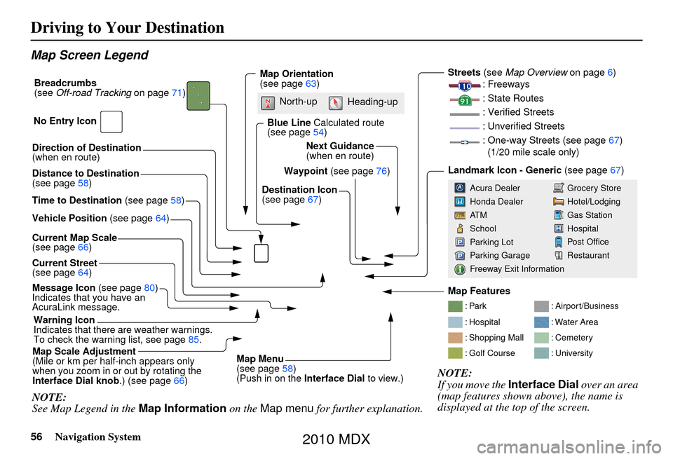
Map Screen Legend
Direction of Destination
(when en route)
Vehicle Position (see page64)
Current Map Scale
(see page 66)
Message Icon (see page80)
Indicates that you have an
AcuraLink message.
Warning Icon
Indicates that there are weather warnings.
To check the warning list, see page 85.
Current Street
(see page
64)
Map Scale Adjustment
(Mile or km per half-inch appears only
when you zoom in or out by rotating the
Interface Dial knob .) (see page66)
NOTE:
See Map Legend in the Map Information on the Map menu for further explanation.
Waypoint (see page76)
Map Orientation
(see page
63)
Breadcrumbs
(see
Off-road Tracking on page71)
NOTE:
If you move the Interface Dial over an area
(map features shown above), the name is
displayed at the top of the screen.
Blue Line Calculated route
(see page 54)
Distance to Destination
(see page 58)
Time to Destination (see page58) Destination Icon
(see page
67)
Next Guidance
(when en route)
: Par k
: Hospital
: Shopping Mall
: Golf Course
: Airport/Business
: Water Area
: Cemetery
: University
Streets (see
Map Overview on page6)
: Freeways
: State Routes
: Verified Streets
: Unverified Streets
: One-way Streets (see page 67)
(1/20 mile scale only)
Landmark Icon - Generic (see page67)
Grocery Store
Hotel/Lodging
Gas Station
Hospital
Post Office
Restaurant
Acura Dealer
Honda Dealer
AT M
School
Parking Lot
Parking Garage
Freeway Exit Information
No Entry Icon
Map Menu
(see page
58)
(Push in on the Interface Dial to view.)
North-up
Heading-up
Map Features
2010 MDX
Page 60 of 184
60Navigation System
Driving to Your Destination
When you select Exit Info. by moving
the Interface Dial to the right, you can
display a list of the freeway exits en
route (see page 60).
Press the CANCEL button or the
BACK button, or move the Interface
Dial down to return to the previous
screen.
You can scroll one guidance point at a
time by rotating the Interface Dial
knob.
The route guidance display disappears
and guidance ends wh en you reach your
destination. Press the MENU button to
return to the MENU screen ( Dest.
MENU 1 or 2).Exit Info. (Freeway Exit
Information)
You can search freeway exit
information (gas sta tions, restaurants,
ATMs, etc.) and add new destinations or
waypoints to the calcu lated route. Select
Exit Info. on the Guidance menu
screen, and a list of freeway exits for the
route is displayed.
If you select the fr eeway exit you plan
on taking, a list of businesses in the area
will be displayed. You can choose a
listing to set as a new destination or
waypoint, and say or select OK. On the
map screen, you can display
Freeway Exit information using the
Interface Dial . The Exit Info icon will
only be displayed on the map screen if
there is any freeway exit information
available. Choose the 1/4, 1/2, or 1 mile
scale, then move the crosshairs to the
desired Exit Info icon and push in on the
Interface Dial . Choose a place from
the list and set it as a new destination or
waypoint.
NOTE:
To turn on “Freeway exit information”
on the map screen, display the icon bar
and select the icon (see page 62).
2010 MDX
Page 62 of 184
62Navigation System
Driving to Your Destination
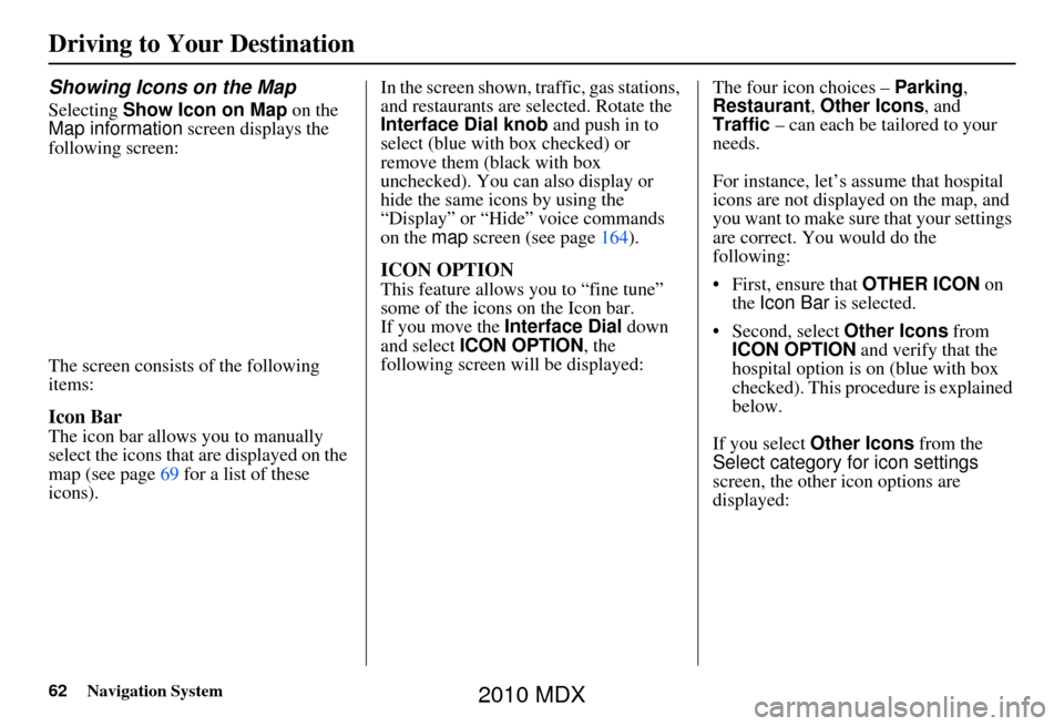
Showing Icons on the Map
Selecting Show Icon on Map on the
Map information screen displays the
following screen:
The screen consists of the following
items:
Icon Bar
The icon bar allows you to manually
select the icons that are displayed on the
map (see page 69 for a list of these
icons). In the screen shown, traffic, gas stations,
and restaurants are selected. Rotate the
Interface Dial knob and push in to
select (blue with box checked) or
remove them (black with box
unchecked). You can also display or
hide the same icons by using the
“Display” or “Hide” voice commands
on the
map screen (see page 164).
ICON OPTION
This feature allows you to “fine tune”
some of the icons on the Icon bar.
If you move the Interface Dial down
and select ICON OPTION, the
following screen will be displayed: The four icon choices –
Parking,
Restaurant, Other Icons, and
Traffic – can each be tailored to your
needs.
For instance, let’s assume that hospital
icons are not displayed on the map, and
you want to make sure that your settings
are correct. You would do the
following:
• First, ensure that OTHER ICON on
the Icon Bar is selected.
• Second, select Other Icons from
ICON OPTION and verify that the
hospital option is on (blue with box
checked). This procedure is explained
below.
If you select Other Icons from the
Select category for icon settings
screen, the other icon options are
displayed:
2010 MDX
Page 67 of 184
Navigation System67
Driving to Your Destination
Destination Icon
The destination icon only shows the
approximate location of the destination.
This occurs because a city block can
have as many as 100 possible addresses
(for example, the 1400 block is followed
by the 1500 block.) Since most cities
use only a portion of the 100 possible
addresses (for example, in the 1400
block, the addresses may only go up to
1425 before the 1500 block starts).
Therefore, the address 1425 will be
shown a quarter of the way down the
block by the system instead of near the
end of the block where the destination is
actually located.
Tip:
When en route, you can view a map
showing your destination. Using voice
control, say “Display destination map.”
Various Other Icons
Landmark Icons
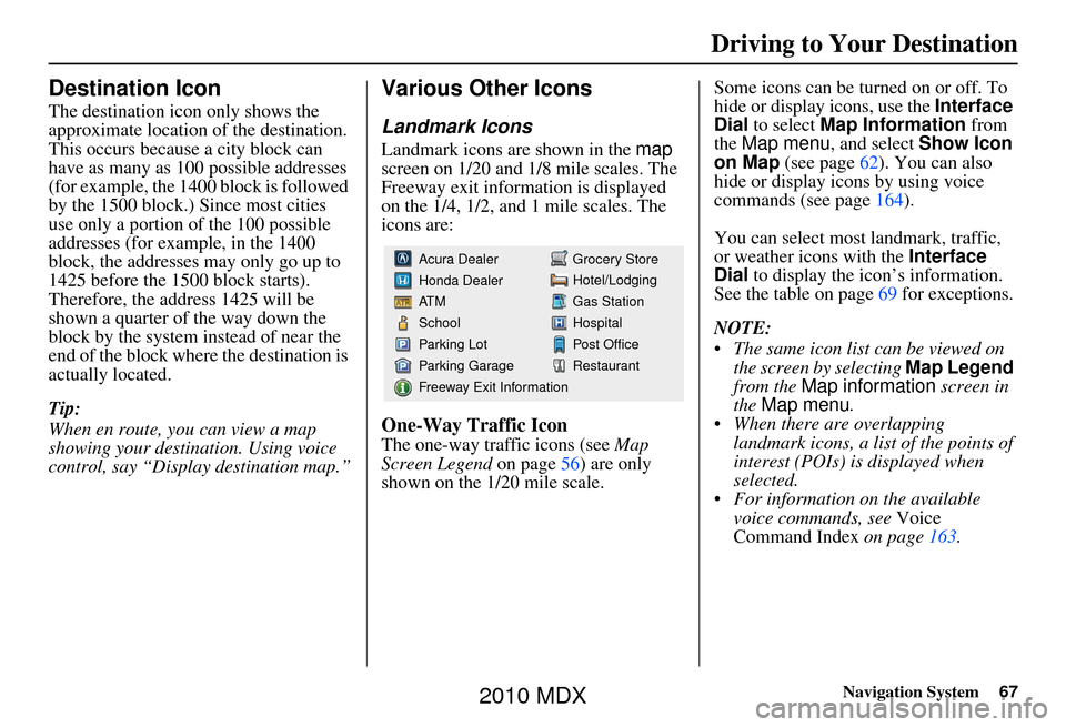
Landmark icons are shown in the map
screen on 1/20 and 1/8 mile scales. The
Freeway exit information is displayed
on the 1/4, 1/2, and 1 mile scales. The
icons are:
One-Way Traffic Icon
The one-way traffic icons (see Map
Screen Legend on page 56) are only
shown on the 1/20 mile scale. Some icons can be turned on or off. To
hide or display icons, use the
Interface
Dial to select Map Information from
the Map menu , and select Show Icon
on Map (see page 62). You can also
hide or display icons by using voice
commands (see page 164).
You can select most landmark, traffic,
or weather icons with the Interface
Dial to display the icon’s information.
See the table on page 69 for exceptions.
NOTE:
The same icon list can be viewed on the screen by selecting Map Legend
from the Map information screen in
the Map menu .
When there are overlapping landmark icons, a list of the points of
interest (POIs) is displayed when
selected.
For information on the available voice commands, see Voice
Command Index on page163.
Grocery Store
Hotel/Lodging
Gas Station
Hospital
Post Office
Restaurant
Acura Dealer
Honda Dealer
AT M
School
Parking Lot
Parking Garage
Freeway Exit Information
2010 MDX
Page 69 of 184
Navigation System69
Driving to Your Destination
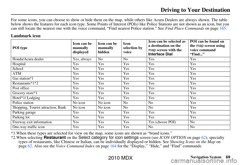
For some icons, you can choose to show or hide them on the map, while others like Acura Dealers are always shown. The table
below shows the features for each icon type. Some Points of Interest (POIs) like Police Stations are not shown as an icon, but you
can still locate the nearest one with the voice command, “Find nearest Police station.” See Find Place Commands on page165.
Landmark icon
*1.When these types are se lected for view on the map, some icons are shown as “brand icons.”
*2.When selecting Restaurant on the Select category for icon settings screen (see ICON OPTION on page 62), specialty
types of restaurants, like Chinese or Italian, can be individually displayed or hidden. See Showing Icons on the Map on
page 62. Also see the Voice Command Index on page164 for the “Display,” “Hide,” and “Find” commands.
POI type Icon can be
manually
displayedIcon can be
manually
hiddenIcon
selection by
voiceIcon can be selected as
a destination on the
map
screen with the
Interface Dial POI can be found on
the
map screen using
voice command
“Find...”
Honda/Acura dealer Yes, always No NoYes Yes
Hospital Yes Yes Yes Yes Yes
School Yes Yes Yes Yes Yes
ATM Yes Yes Yes Yes Yes
Gas station*1 Yes Yes Yes Yes Yes
Restaurants*1*2 Yes Yes Yes Yes Yes
Post office Yes Yes Yes Yes Yes
Grocery store*1 Yes Yes Yes Yes Yes
Hotel*1/ Lodging Yes Yes Yes Yes Yes
Police station No icon No icon No NoYes
Shopping, Tourist attr action, Bank No icon No icon No NoYes
Parking garage Yes Yes Yes Yes Yes
Parking lot Yes Yes Yes Yes Yes
Freeway exit information Yes Yes Yes Yes (choose POI) No
One-way traffic icon Yes Yes Yes No No
2010 MDX
Page 76 of 184

76Navigation System
Driving to Your Destination
Waypoint
Waypoints allow you to add an interim
“pit stop” while traveling to a
destination. For instance, you may want
to stop for gas or food, and then
continue on to your destination.
Although you can enter up to five places
including the destination at a time,
typically you may never use more than
one at a time.
Waypoints are routed to in the order
they were entered (number 1 first, etc.),
with your final destination routed to last.
When you enter waypoi nts, they appear
on the map screen as small red flags
numbered 1-4.
Adding Waypoint
From the MENU screen ( Route), if you
say or select Waypoint, the Add
waypoint screen is displayed.
Select either SEARCH AROUND or
SEARCH ALONG by rotating
Interface Dial knob. Next, select the category from the
“Main” or “Fav. Subcategory” tab on
the Category
screen, then follow the
menu prompts to select a destination.
When the system performs a search
from SEARCH ALONG , it displays
matches that lie within a corridor on
either side and in front of your route.
From SEARCH AROUND , the system
displays matches that are a uniform
distance from the departure point/
waypoint/destination.
The search “corridor” distance value
can be changed in Edit Waypoint
Search Area in SETUP (see
page 112).
2010 MDX