2008 NISSAN ALTIMA HYBRID sat nav
[x] Cancel search: sat navPage 162 of 237

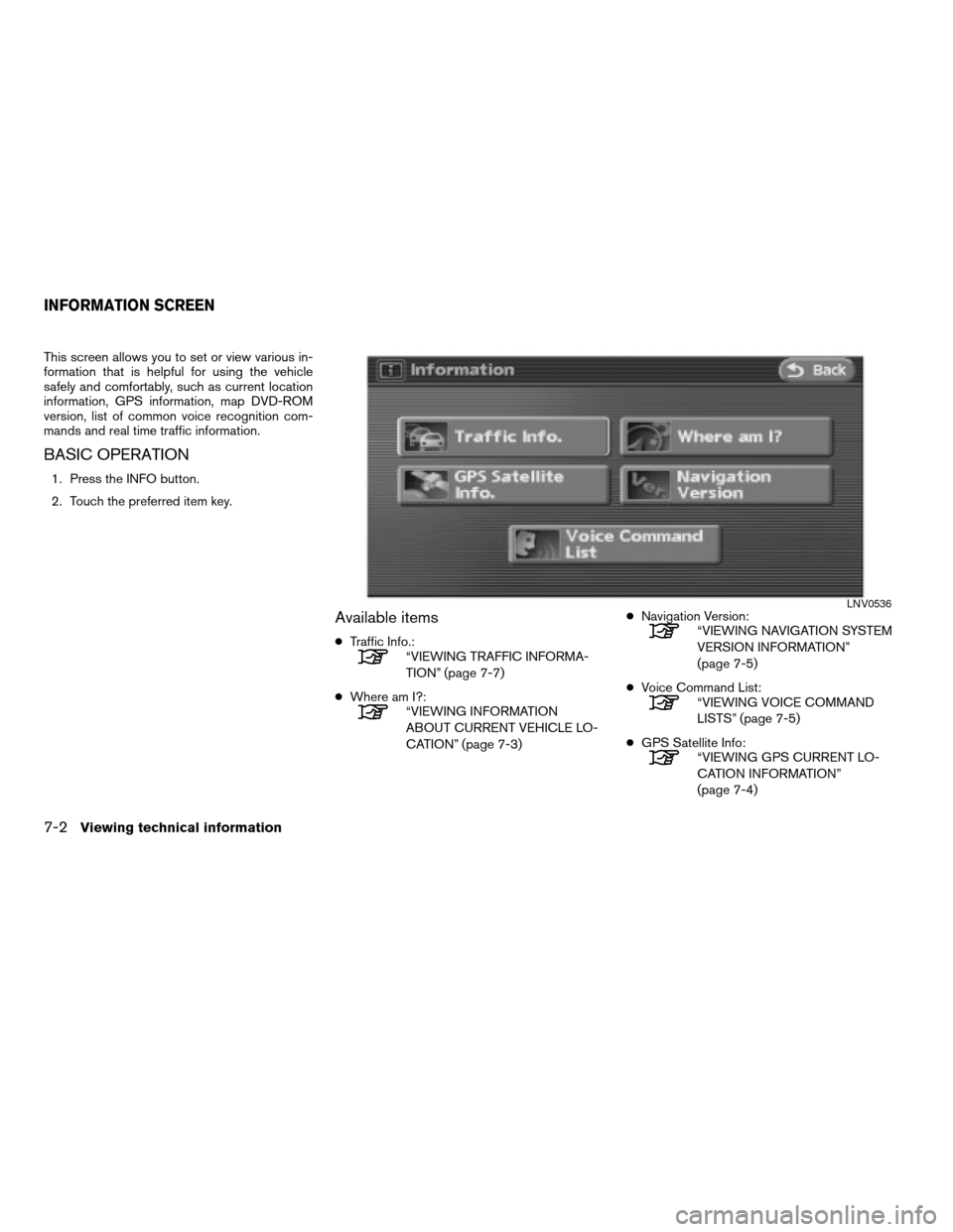
This screen allows you to set or view various in-
formation that is helpful for using the vehicle
safely and comfortably, such as current location
information, GPS information, map DVD-ROM
version, list of common voice recognition com-
mands and real time traffic information.
BASIC OPERATION
1. Press the INFO button.
2. Touch the preferred item key.
Available items
cTraffic Info.:“VIEWING TRAFFIC INFORMA-
TION” (page 7-7)
cWhere am I?:
“VIEWING INFORMATION
ABOUT CURRENT VEHICLE LO-
CATION” (page 7-3)cNavigation Version:
“VIEWING NAVIGATION SYSTEM
VERSION INFORMATION”
(page 7-5)
cVoice Command List:
“VIEWING VOICE COMMAND
LISTS” (page 7-5)
cGPS Satellite Info:
“VIEWING GPS CURRENT LO-
CATION INFORMATION”
(page 7-4)
LNV0536
INFORMATION SCREEN
7-2Viewing technical information
ZREVIEW COPYÐ2008 Altima(alt)
Navigation System OMÐUSA_English(nna)
03/13/07Ðarosenma
X
Page 164 of 237

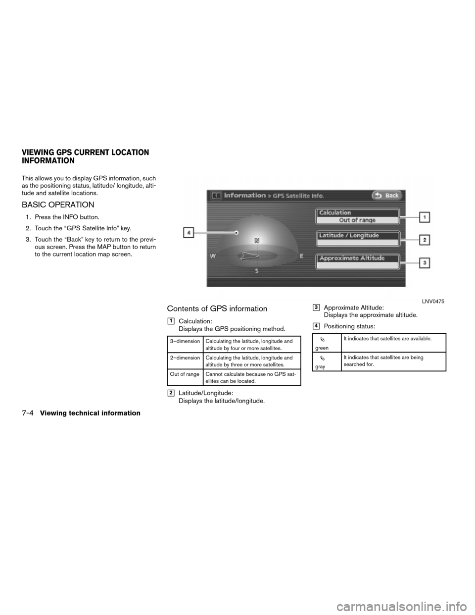
This allows you to display GPS information, such
as the positioning status, latitude/ longitude, alti-
tude and satellite locations.
BASIC OPERATION
1. Press the INFO button.
2. Touch the “GPS Satellite Info” key.
3. Touch the “Back” key to return to the previ-
ous screen. Press the MAP button to return
to the current location map screen.
Contents of GPS information
h1Calculation:
Displays the GPS positioning method.
3–dimension Calculating the latitude, longitude and
altitude by four or more satellites.
2–dimension Calculating the latitude, longitude and
altitude by three or more satellites.
Out of range Cannot calculate because no GPS sat-
ellites can be located.
h2Latitude/Longitude:
Displays the latitude/longitude.
h3Approximate Altitude:
Displays the approximate altitude.
h4Positioning status:
greenIt indicates that satellites are available.
grayIt indicates that satellites are being
searched for.
LNV0475
VIEWING GPS CURRENT LOCATION
INFORMATION
7-4Viewing technical information
ZREVIEW COPYÐ2008 Altima(alt)
Navigation System OMÐUSA_English(nna)
03/13/07Ðarosenma
X
Page 167 of 237

XMTNavTraffic™ information is a subscription
service offered by XMTSatellite Radio.
This service provides real time information re-
garding traffic flow, accidents, road construction
and other incidents, where available.
XMTNavTraffic™ combines information from
commercial and public traffic data providers in-
cluding government departments of
transportation, police, emergency services, road
sensors, cameras, and aircraft reports. The traf-
fic information is broadcast to the vehicle by the
XMTsatellites. Available traffic information on
the route the driver selected is shown on the
navigation screen so traffic conditions between
you and the destination are known. Three types
of real-time traffic information for major road-
ways are shown on the navigation system:
cUnscheduled traffic data for example, acci-
dents and disabled vehicles.
cScheduled traffic data, for example road con-
struction and road closures.
cTraffic flow information (rate of speed data) .
mWARNING
XMTNavTraffic™ information is not a
substitute for attentive driving. Traffic
conditions change constantly and
emergency situations can arise without
warning. Relying only on XMTNavTraf-
fic™ information may lead to a collision
and could result in serious personal
injury.
NOTE:
Flow information is provided for only
roads equipped with traffic sensors and is
not available in all markets covered by the
service. Flow data may not be available on
portions of a road that is under
construction.
XMTNavTraffic™ information is available in lim-
ited markets. To subscribe or to check if this ser-
vice is available in your area:
call 1-800-XM-RADIO (1-800-967-2346)
or see www.xmradio.com/xmnavtraffic/
BASIC OPERATION
1. Press the INFO button.
2. Touch the “Traffic Info.” key.
3. Touch the “Back” key to return to the previ-
ous screen. Press the MAP button to return
to the current location map screen.
VIEWING TRAFFIC INFORMATION (if
so equipped)
Viewing technical information7-7
ZREVIEW COPYÐ2008 Altima(alt)
Navigation System OMÐUSA_English(nna)
03/06/07Ðarosenma
X
Page 188 of 237

NISSAN Voice Recognition allows hands-free
operation of the navigation system and other
systems equipped on this vehicle, such as the
phone.
INFO:
cVoice recognition can be used to set destina-
tion street addresses that exist within the con-
tinental United States (48 states) . Street ad-
dresses in Canada, Alaska and Hawaii cannot
be entered using voice recognition.
USING THE SYSTEM
Initialization
When the ignition switch is pushed to the ON
position, NISSAN Voice Recognition is
initialized, which takes a few seconds. When
completed, the system is ready to accept voice
commands. If the
is pressed before the
initialization completes, the display will show the
message: “Phonetic data downloaded. Please
wait.”
BASIC VOICE CONTROL
Before starting
To get the best recognition performance out of
NISSAN Voice Recognition, observe the follow-
ing:
cThe interior of the vehicle should be as quiet
as possible. Close the windows to eliminate
the surrounding noises (traffic noise and vi-
bration sounds, etc.) , which may prevent the
system from correctly recognizing the voice
commands.
cWait until the tone sounds before speaking a
command. Otherwise, the command will not
be recognized properly.
cSpeak in a natural conversational voice with-
out pausing between words.
Giving voice commands
1. Press thebutton located on the
steering wheel switches.
LNV0444
NISSAN VOICE RECOGNITION
9-2Voice recognition
ZREVIEW COPYÐ2008 Altima(alt)
Navigation System OMÐUSA_English(nna)
03/06/07Ðarosenma
X
Page 198 of 237

ROUTE GUIDANCE
The main features of the NISSAN Navigation
System are visual guidance and voice guidance
in selected map coverage areas. Utilizing a net-
work of GPS (Global Positioning System)
satellites, the NISSAN Navigation System tracks
your location on the map and navigates you to a
preferred location.
Once you set the destination in a map coverage
area, the NISSAN Navigation System will calcu-
late a route from your current location to your
destination. The real-time map display and turn-
by-turn voice guidance leads the driver along the
route.
These features can be especially helpful when
driving to unfamiliar locations.
The system may be unable to set a destination
and/or calculate a route when the destination is
outside the map coverage area. Additionally,
voice guidance may not be available if the desti-
nation is outside the map coverage area. For
more information on how to set a destination, re-
fer to section 4.
POINTS OF INTEREST (POI) DIREC-
TORY
The NISSAN Navigation System offers an exten-
sive Points of Interest (POI) directory in map
coverage areas. This directory includes a wide
variety of destinations ranging from gas stations,
ATMs, and restaurants to casinos, ski resorts,
shopping centers and businesses. By accessing
the Points of Interest directory, you can search
for addresses and phone numbers for a
destination, and just by pushing a button, the
NISSAN Navigation System will calculate a
route to the destination.
The POI directory has many uses. For example,
the directory can be sorted by the various types
of restaurants near your current location. If you
need an ATM or gas station, the NISSAN Navi-
gation System can navigate you to the closest
preferred location.
For more information on how to use the Points of
Interest directory, refer to section 4.
ADDRESS BOOK
The Address Book can store up to 100 locations
from map coverage areas into a personal
directory. This is especially useful for frequently
visited locations, such as clients, relatives and
friends. The Address Book function allows easyaccess to frequently visited locations when set-
ting them as your destination.
For more information on how to use the Address
Book, refer to section 6.
AVOID AREA
The Avoid Area function allows you to identify ar-
eas or freeways that you would like the NISSAN
Navigation System to avoid when calculating
routes. For example, if a freeway or area is al-
ways congested with traffic, you can set the
NISSAN Navigation System to calculate routes
that exclude that freeway or area.
For more information on the Avoid Area function,
refer to section 6.
XMTNAVTRAFFIC™ INFORMATION
When available, the Traffic Information broad-
cast allows you to avoid delays due to traffic
incidents. Traffic jams, roadwork, closed roads
around your current location, etc. are repre-
sented graphically on the map by icons depict-
ing the nature of the event. Incidents on the route
are automatically brought to your attention when
you approach them.
The Traffic Information feature, via the guidance
mode, allows you to detour around traffic
problems. For more information on the Traffic In-
formation feature, please refer to section 7.
FEATURES OF THIS NAVIGATION
SYSTEM
10-2General system information
ZREVIEW COPYÐ2008 Altima(alt)
Navigation System OMÐUSA_English(nna)
03/06/07Ðarosenma
X
Page 200 of 237

DISPLAY OF CURRENT VEHICLE
LOCATION
This navigation system combines the data ob-
tained from the vehicle (by gyro sensor) and from
GPS (Global Positioning System) satellites to
calculate the current location of the vehicle. This
position is then displayed throughout route guid-
ance to a destination.
WHAT IS GPS (Global Positioning
System)?
GPS is a position detecting system that uses
satellites deployed by the U.S. government. This
navigation system receives radio signals from
three or more different satellites that orbit
13,049 miles (21,000 km) above the earth in
space, and detects the position of the vehicle by
utilizing the principle of triangulation.
Positioning adjustment
When the system judges that the vehicle posi-
tion information is not accurate based on vehicle
speed and gyro sensor data calculations, the
system will automatically adjust the position of
the vehicle icon using GPS signals.
Receiving signals from GPS satellites
The reception of GPS signals can be weak, de-
pending on the environment. Vehicles in the fol-
lowing areas/environments may not receive GPS
signals.
CURRENT VEHICLE LOCATION
10-4General system information
ZREVIEW COPYÐ2008 Altima(alt)
Navigation System OMÐUSA_English(nna)
03/06/07Ðarosenma
X
Page 231 of 237

INFO button
Where am I?page 7-3
GPS Satellite Infopage 7-4
Navigation Versionpage 7-5
Voice Command Listpage 7-5
Traffic Info.Info. on Routepage 7-8
Nearby Traffic Info.page 7-9
User Locationspage 7-10
Traffic Info Settingspage 7-11
INFORMATION SCREEN
Troubleshooting guide11-17
ZREVIEW COPYÐ2008 Altima(alt)
Navigation System OMÐUSA_English(nna)
03/13/07Ðarosenma
X