2008 MAZDA MODEL 6 change time
[x] Cancel search: change timePage 6 of 58

6
Before Use
Navigation
Set Up
RDM-TMCIf
necessary
Rear View
Monitor
Safety Infor mation
nRead this owner’s manual for your Navigation System carefully before using the system.
It contains instructions about how to use the system in a safe and effective manner.
Mazda assumes no responsibility for any problems resulting from failure to observe the instructions
given in this manual.
nThis manual uses pictographs to show you how to use the product safely and to alert you to potential
dangers resulting from improper connections and operation. The meanings of the pictographs are
explained below. It is important that you fully understand the pictographs and explanations in order to
use this manual and the system properly.
WarningWarning
The presence of this Warning symbol in the text is intended to
alert you to the importance of heeding the operation
instructions. Failure to heed the instructions may result in
severe injury or death.
nDo not keep your eyes fixed on the monitor screen or operate the system
while driving.
Do not change the settings and destination locations while driving. Minimize the time
spent on viewing the monitor screen and listening to the voice guidance while driving.
Operating the system will distract the driver from looking ahead of the vehicle and can
cause accidents. Always stop the vehicle in a safe location and use the parking brake
before operating the system.
n
Always obey local traffic regulations. Your guided route may include roads that are not open to vehicles or are closed due to
traffic regulations. Comply with the local traffic regulations and take another route.
n
Do not use the unit when it is out of order.If the unit is out of order (no image, no sound) or in an abnormal state (has foreign matter
in it, is exposed to water, is smoking, or smells), then turn it off immediately and consult
with an Expert dealer, we recommend an Authorized Mazda Dealer. Using the unit in an
out-of-order condition may lead to accidents, fires, or electric shocks.
n
Use the proper power supply. This product is designed for operation with a negative grounded 12 V DC battery system.
n
Do not disassemble. Do not disassemble the product or attempt to repair it yourself. If the product needs to be
repaired, take it to an Expert dealer, we recommend an Authorized Mazda Dealer.
Warnings
<00310025003e00280025001a004300320025003a002d0043002900250012004600530053004f0004000400340045004b00490004001a00040004002a0056004d00480045005d00100004002e0059005200490004001c00100004001600140014001b000400
040017001e0019001b000400340031>
Page 12 of 58

12
RoutingAddress
Book
Getting started
Activation
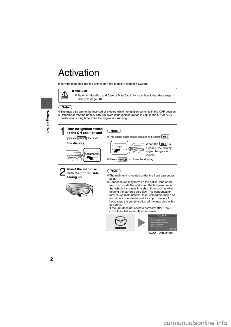
Insert the map disc into the unit to start the Mobile Navigation System.
Note
lThe map disc cannot be inserted or ejected while the ignition switch is in the OFF position.
lRemember that the battery can run down if the ignition switch is kept in the ON or ACC
position for a long time while the engine not running.
nMap Disc
lRefer to “Handling and Care of Map Discs” to know how to handle a map
disc ( page 58).
1
Turn the ignition switch
to the ON position and
press to open
the display.Note
lThis display angle can be adjusted by pressing .
When the is
pressed, the display
angle changes in
stages.
lPress to close the display.
2
Insert the map disc
with the printed side
facing up.Note
lThe main unit is located under the front passenger
seat.
lCondensation may form on the optical lens or the
map disc inside the unit when the temperature in
the vehicle increases in a short time such as when
heating the car on a cold day. This condensation
may cause malfunctions. If so, unload the map disc
and do not operate the unit for approximately 1
hour. Wipe the condensation off the map disc with a
soft cloth.
If the unit does not operate correctly after 1 hour,
consult an Authorized Mazda Dealer.
Cautions
OPEN/CLOSETILT
TILT
OPEN/CLOSE
(CAUTION) screen
<00310025003e00280025001a004300320025003a002d0043002900250012004600530053004f0004000400340045004b004900040015001600040004002a0056004d00480045005d00100004002e0059005200490004001c00100004001600140014001b00
0400040017001e0019001b000400340031>
Page 16 of 58

16
RoutingAddress
Book
Getting started
Navigation Set Up
lYou can alter the map display conditions, the route guidance conditions and show the
system information.
nStop your vehicle before the following operations. Do not change the settings and destination locations while driving. Minimize the time
spent viewing the monitor screen and listening to the voice guidance while driving.
Operating the system will distract the driver from looking ahead of the vehicle and may
cause an accident.
Always stop the vehicle in a safe location and put the parking brake on before operating
the system.
Before Steps select
Warning
MENUENTERENTER
Open
[NAVIGATION SETUP] ( page 17)
( page 19)
( page 20)
( page 21)
( page 22)
( page 24)
<00310025003e00280025001a004300320025003a002d0043002900250012004600530053004f0004000400340045004b004900040015001a00040004002a0056004d00480045005d00100004002e0059005200490004001c00100004001600140014001b00
0400040017001e0019001b000400340031>
Page 17 of 58
![MAZDA MODEL 6 2008 Navigation Manual (in English) 17
Getting started
Navigation Set Up
Before Steps
select
select
User Setting
MENUENTERENTER
ENTERENTER
Open the
[USER SETTINGS]
screen
nMap Color
Select a screen color from to options MAZDA MODEL 6 2008 Navigation Manual (in English) 17
Getting started
Navigation Set Up
Before Steps
select
select
User Setting
MENUENTERENTER
ENTERENTER
Open the
[USER SETTINGS]
screen
nMap Color
Select a screen color from to options](/manual-img/28/13578/w960_13578-16.png)
17
Getting started
Navigation Set Up
Before Steps
select
select
User Setting
MENUENTERENTER
ENTERENTER
Open the
[USER SETTINGS]
screen
nMap Color
Select a screen color from to options.
nMap Mode
lAuto : The display will automatically switch between Day
and Night illumination mode when the headlights are
turned off and on respectively.
lDay :The display will be presented in Day illumination mode
regardless of whether the headlights are on or off.
lNight : The display will be presented in Night illumination mode
regardless of whether the headlights are on or off.
nDistance
Select the distance unit from or .
nAverage Speed
Set the average speed for each road to be driven.
(This function sets the standard speed (average vehicle speed
for each route) used for calculating the estimated arrival time
when calculating the route time.)
: Average speed setting
:Changes back to default
nRoad Restriction Warnings
The display of warnings during route guidance when passing
through areas with traffic restrictions can be turned on or off.
<00310025003e00280025001a004300320025003a002d0043002900250012004600530053004f0004000400340045004b004900040015001b00040004002a0056004d00480045005d00100004002e0059005200490004001c00100004001600140014001b00
0400040017001e0019001b000400340031>
Page 24 of 58
![MAZDA MODEL 6 2008 Navigation Manual (in English) 24
RoutingAddress
Book
Getting started
Navigation Set Up
This function replaces all the settings in the mobile navigation system with the initial default
settings.
[Default List]
Before Steps
se MAZDA MODEL 6 2008 Navigation Manual (in English) 24
RoutingAddress
Book
Getting started
Navigation Set Up
This function replaces all the settings in the mobile navigation system with the initial default
settings.
[Default List]
Before Steps
se](/manual-img/28/13578/w960_13578-23.png)
24
RoutingAddress
Book
Getting started
Navigation Set Up
This function replaces all the settings in the mobile navigation system with the initial default
settings.
[Default List]
Before Steps
select
select
ItemInitial condition
Menu names
Map Orientation North up
Map display mode Single-screen display
Map Display scale/Map scale for Dual-screen is not object of backup.Single-screen: 10,000 map (1/16 mi)Display guidance language English
Quick-POI map display All Off
Quick-POI Selection A : Gas station
B : ATM
C : Police Station
D : Grocery store
E : All Restaurant
F : Hotel
Search Area US9 (including Washington DC)
Map Color 1
Day/Night/Auto Setting Auto
Distance Units (Miles/KM) (Global setting) Miles
Volume Presets 4
Time display change (12h/24h)24h
Keyboard layout ABC
Arrival Time Time
Navigation Setup (Clock) Off
Navigation Setup (Beep) On
Map Configuration
Freeway Information Off
Guidance Screen ON
Map screen Single
Turn Guidance Screen Turn List
Restore System Defaults
MENUENTERENTER
ENTERENTER
Open the [SYSTEM DEFAULTS] screen
Select .
If you execute Restore System Defaults, all of your stored setting data will be deleted.
<00310025003e00280025001a004300320025003a002d0043002900250012004600530053004f0004000400340045004b004900040016001800040004002a0056004d00480045005d00100004002e0059005200490004001c00100004001600140014001b00
0400040017001e0019001b000400340031>
Page 27 of 58

27
Getting started
Screen change
nDo not keep your eyes fixed on the monitor screen or operate the system
while driving
Do not change the settings and destination locations while driving. Minimize the time
spent viewing the monitor screen and listening to the voice guidance while driving.
Operating the system will distract the driver from looking ahead of the vehicle and may
cause an accident. Always stop the vehicle in a safe location and use the parking brake
before operating the system.
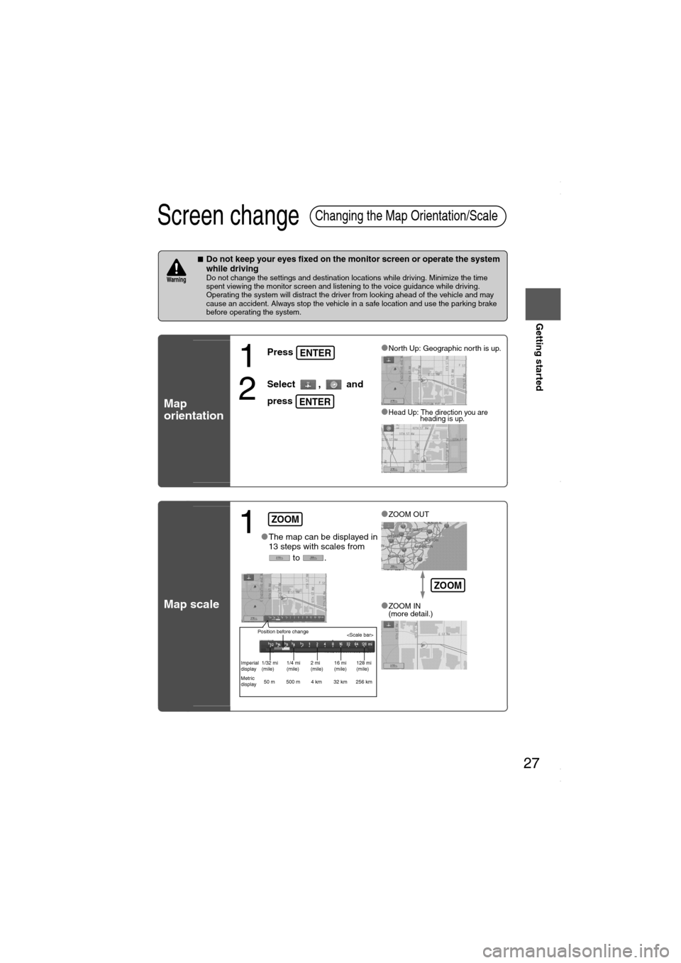
Map
orientation
Map scale
Changing the Map Orientation/Scale
Warning
1
Press
2
Select , and
press
lNorth Up: Geographic north is up.
lHead Up: The direction you are
heading is up.
ENTER
ENTER
1lThe map can be displayed in
13 steps with scales from
to .l
ZOOM OUT
lZOOM IN
(more detail.)
ZOOM
Position before change
Imperial
display1/32 mi
(mile)1/4 mi
(mile)2 mi
(mile)16 mi
(mile)128 mi
(mile)
Metric
display50 m 500 m 4 km 32 km 256 km
ZOOM
<00310025003e00280025001a004300320025003a002d0043002900250012004600530053004f0004000400340045004b004900040016001b00040004002a0056004d00480045005d00100004002e0059005200490004001c00100004001600140014001b00
0400040017001e0019001b000400340031>
Page 29 of 58

29
Before
UseGetting
started
Routing
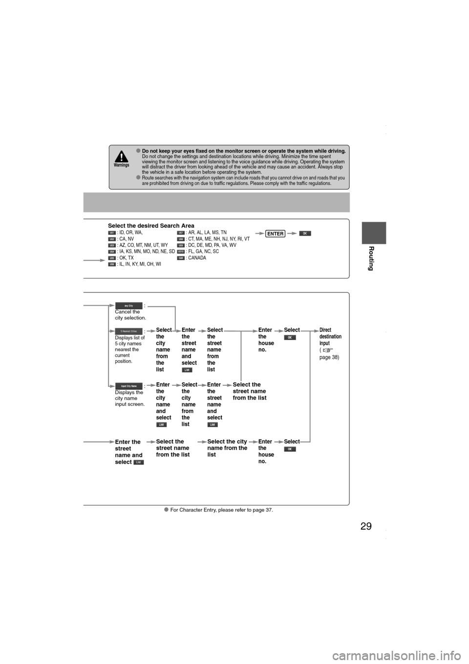
lFor Character Entry, please refer to page 37.
lDo not keep your eyes fixed on the monitor screen or operate the system while driving.Do not change the settings and destination locations while driving. Minimize the time spent
viewing the monitor screen and listening to the voice guidance while driving. Operating the system
will distract the driver from looking ahead of the vehicle and may cause an accident. Always stop
the vehicle in a safe location before operating the system.
lRoute searches with the navigation system can include roads that you cannot drive on and roads that you
are prohibited from driving on due to traffic regulations. Please comply with the traffic regulations.
Warnings
Select
Select the desired Search Area : ID, OR, WA, : AR, AL, LA, MS, TN
: CA, NV : CT, MA, ME, NH, NJ, NY, RI, VT
: AZ, CO, MT, NM, UT, WY : DC, DE, MD, PA, VA, WV
: IA, KS, MN, MO, ND, NE, SD : FL, GA, NC, SC
: OK, TX : CANADA
: IL, IN, KY, MI, OH, WIENTER
When narrowing
down to city name
Select
When narrowing
down to street name
Select
Enter the
street
name and
select
:
Cancel the
city selection.
:
Displays list of
5 city name
s
nearest the
current
position.
:
Displays the
city name
input screen.
Select the
street name
from the list
Select
the
city
name
from
the
list
Enter
the
city
name
and
selectEnter
the
street
name
and
select
Select
the
city
name
from
the
list
Select the city
name from the
list
Select
the
street
name
from
the
list
Enter
the
street
name
and
select
Select the
street name
from the list
Enter
the
house
no. Enter
the
house
no.
Select
SelectDirect
destination
input
(
page 38)
<00310025003e00280025001a004300320025003a002d0043002900250012004600530053004f0004000400340045004b004900040016001d00040004002a0056004d00480045005d00100004002e0059005200490004001c00100004001600140014001b00
0400040017001e0019001b000400340031>
Page 38 of 58

38
Before
UseGetting
started
Routing
Direct Destination Input
Direct
Destination
Input
Selecting
Route
1
Position the
cursor on your
destination on
the map
Scroll the map and change the map
scale if necessary.
2 Select
3
Select .Route calculation will be carried out and the entire route
will be displayed on the map.
Select (Way point) to set the address as a way point
on your route ( page 44). You can set up to 5 way-
points per trip.
4
Select .Route guidance begins using displayed route.
Note
lIf your desired route cannot be found, (Route
Options) allows the route option settings to be changed.
( page 40)
lSelecting for five seconds or more will launch the
Demo mode.
Operate after Step 3 of [Direct Destination Input]
4
The calculation route can be selected from one of three
types namely, Quick (the fastest route), Altern. (the
standard route), or Short (the shortest route).
5
Select (Information).Details regarding the individual routes (i.e., required time
total distance, roads used, etc.)
Select either , , or
, and then select
when you have decided
on the route to be used.
ENTER
ENTER
ENTER
<00310025003e00280025001a004300320025003a002d0043002900250012004600530053004f0004000400340045004b004900040017001c00040004002a0056004d00480045005d00100004002e0059005200490004001c00100004001600140014001b00
0400040017001e0019001b000400340031>