xlv
“Whole route”: If you select this switch,
the system will calculate an entire new
route to the destination.
INFORMATION
�When your vehicle is on a freeway,
the detour distance selections are 5,
15 and 25 miles.
�The system may not be able to cal-
culate a detour route depending on
the selected distance and surround-
ing road conditions.
“Search condition”: To change the condi-
tions of the searching route. (See page
xcvii.)
“Quick”: A route on which you can reach
the destination in the shortest time.
“Short”: A route on which you can reach
the destination in the shortest distance.
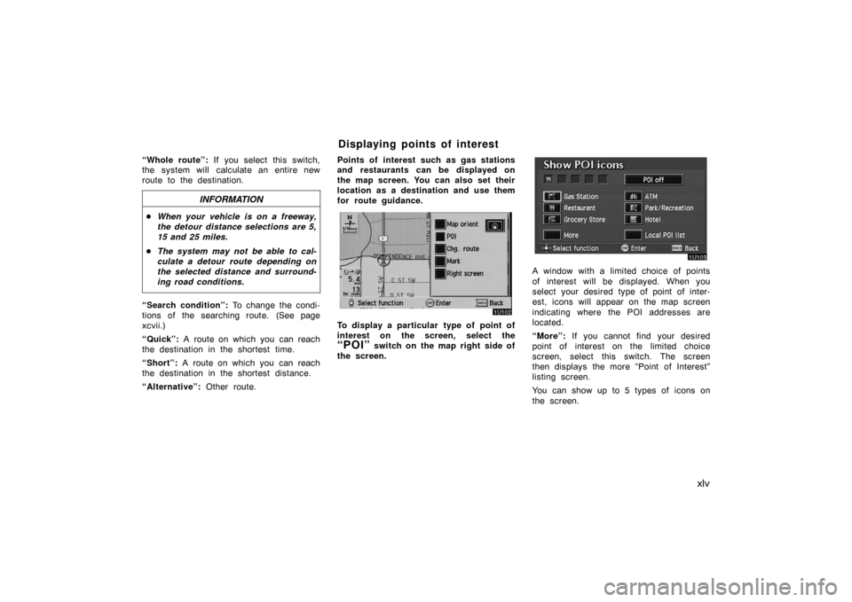
“Alternative”: Other route.Points of interest such as gas stations
and restaurants can be displayed on
the map screen. You can also set their
location as a destination and use them
for route guidance.
To display a particular type of point of
interest on the screen, select the
“POI” switch on the map right side of
the screen.
A window with a limited choice of points
of interest will be displayed. When you
select your desired type of point of inter-
est, icons will appear on the map screen
indicating where the POI addresses are
located.
“More”: If you cannot find your desired
point of interest on the limited choice
screen, select this switch. The screen
then displays the more “Point of Interest”
listing screen.
You can show up to 5 types of icons on
the screen.
Displaying points of interest
lv
Map database is made based on the
maps, 2006 edition of DENSO, whose
information source comes from NAVTEQ
maps, Tele Atlas maps and infoUSA
POIs.
�2005 NAVTEQ. All rights reserved.�2005 Tele Atlas North America, Inc.
All rights reserved. This material is pro-
prietary and the subject of copyright
protection and other intellectual proper-
ty rights owned by or licensed to Tele
Atlas North America, Inc. The use of
this material is subject to the terms of
a license agreement. You will be held
liable for any unauthorized copying or
disclosure of this material.
Data by infoUSA Copyright
�2005, All
Rights Reserved.
This product contains proprietary and
confidential property of NAVTEQ, Tele
Atlas and infoUSA. Unauthorized use,
including duplication of this product is
expressly prohibited.There are two types of areas available
for route guidance. (See the following
pages.) In one type of area, primarily
around metropolitan centers, detailed
route guidance is available for the en-
tire area. In the other type of area, all
roads are displayed on the map but
route guidance is limited. The naviga-
tion route might lack precision because
the data (no right turns, one�way traf-
fic, etc.) is not complete. It is still pos-
sible to reach the destination by follow-
ing the arrow direction and distance as
shown on the bottom left of the screen.
The arrow points in the direction of the
destination. The distance shown is as
measured in a straight line from the
current vehicle position to the destina-
tion area.COPYRIGHT NOTICE: This area includes
information taken with permission from
Canadian authorities, including
�Her
Majesty the Queen in Right of Canada,
�Queen’s Printer for Ontario.
END�USER TERMS
The data (“Data”) is provided for your
personal, internal use only and not for
resale. It is protected by copyright,
and is subject to the following terms
and conditions which are agreed to by
you, on the one hand, and DENSO
CORPORATION (“[CLIENT]”) and its
licensors (including their licensors and
suppliers) on the other hand.
©2005 NAVTEQ. All rights reserved.
The Data for areas of Canada in-
cludes information taken with permis-
sion from Canadian authorities, includ-
ing: © Her Majesty the Queen in
Right of Canada, © Queen’s Printer
for Ontario, © Canada Post Corpora-
tion, GeoBase �.
Map database information and
updates