2007 PEUGEOT 4007 navigation
[x] Cancel search: navigationPage 179 of 221
11
EQUIPMENT and TELEMA
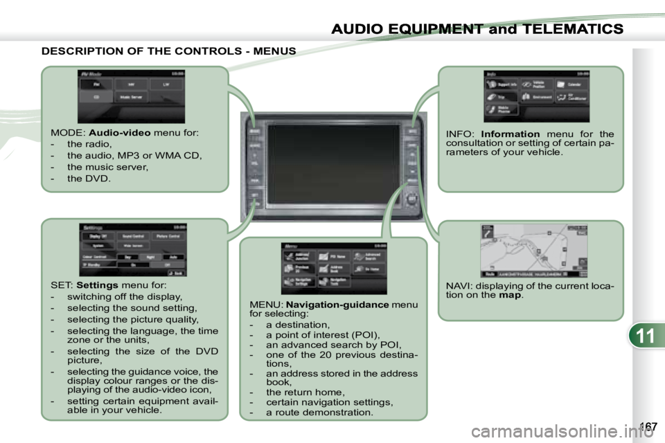
DESCRIPTION OF THE CONTROLS - MENUS DESCRIPTION OF THE CONTROLS - MENUS
MODE: Audio-video menu for:
- the radio,
- the audio, MP3 or WMA CD,
- the music server,
- the DVD.
MENU: Navigation-guidance menu
for selecting:
- a destination,
- a point of interest (POI),
- an advanced search by POI,
- one of the 20 previous destina- tions,
- an address stored in the address book,
- the return home,
- certain navigation settings,
- a route demonstration. NAVI: displaying of the current loca-
tion on the
map .
SET:
Settings menu for:
- switching off the display,
- selecting the sound setting,
- selecting the picture quality,
- selecting the language, the time zone or the units,
- selecting the size of the DVD picture,
- selecting the guidance voice, the display colour ranges or the dis-
playing of the audio-video icon,
- setting certain equipment avail- able in your vehicle. INFO:
Information menu for the
consultation or setting of certain pa-
rameters of your vehicle.
Page 180 of 221
11
AUDIO EQUIPMENT and TELEMATICS
NAVIGATION-GUIDANCE NAVIGATION-GUIDANCE
GPS
What is the navigation system and
the GPS?
The satellite navigation system guides
the driver to the destination that he has
set in accordance with a chosen route.
Initially, it searches for the destination
required by the user, then it calculates
�t�h�e� �r�o�u�t�e� �a�n�d� �fi� �n�a�l�l�y� �i�t� �p�r�o�v�i�d�e�s� �t�h�e� �v�i�-
sual and audible guidance instructions. What precautions should be
observed in order to use the system
under good conditions?
Do not place anything on or near the
GPS aerial.
Do not use any digital communication
equipment (personal computers, etc.)
near the GPS aerial.
� �D�o� �n�o�t� �a�f�fi� �x� �a�n�y� �r�e�fl� �e�c�t�i�v�e� �fi� �l�m�s� �o�r� �fi� �l�m�s�
containing carbon to the window.
The system’s measurements may be
inaccurate if the vehicle is:
- in a tunnel or underground car
park,
- underneath a two-level motorway,
- in an area with several very high buildings,
- surrounded by closely planted trees.
Depending on the vehicle’s situation
and the reception of the GPS informa-
tion, the displayed information may dis-
appear from the display temporarily.
The GPS (Global Position-
ing System) consists of
several satellites distributed
around the earth. They con-
tinuously transmit digital sig-
nals which travel at the speed of light,
on 2 different frequencies.
At any given time, the system receives
its position in relation to the satellites
detected and the time of transmission
of the signal.
This enables the telematic unit to de-
duce its position and therefore that of
the vehicle.
A repositioning process using the map
database stored on the hard disc per-
mits repositioning of the vehicle’s po-
sition on the road network in order to
improve the accuracy of the locating
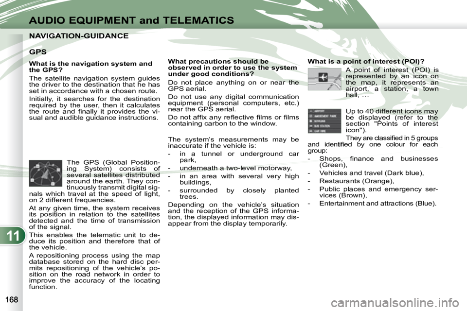
function. What is a point of interest (POI)?
A point of interest (POI) is
represented by an icon on
the map, it represents an
airport, a station, a town
hall, …
Up to 40 different icons may
be displayed (refer to the
section "Points of interest
icon").
� �T�h�e�y� �a�r�e� �c�l�a�s�s�i�fi� �e�d� �i�n� �5� �g�r�o�u�p�s�
�a�n�d� �i�d�e�n�t�i�fi� �e�d� �b�y� �o�n�e� �c�o�l�o�u�r� �f�o�r� �e�a�c�h�
group:
� � � �-� � �S�h�o�p�s�,� �fi� �n�a�n�c�e� �a�n�d� �b�u�s�i�n�e�s�s�e�s� (Green),
- Vehicles and travel (Dark blue),
- Restaurants (Orange),
- Public places and emergency ser- vices (Brown),
- Entertainment and attractions (Blue).
Page 181 of 221
11
K1K2K3
K4K5
K
H
E
F
BCA
D
G
I
J
AUDIO EQUIPMENT and TELEMATICSEQUIPMENT and TELEMA
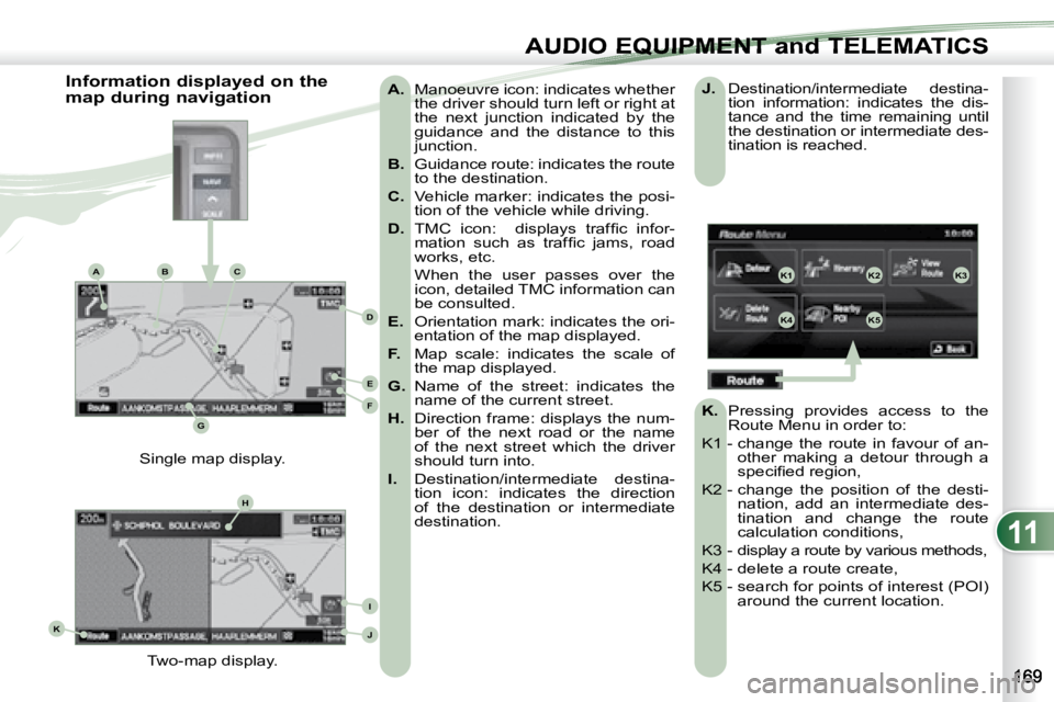
A. Manoeuvre icon: indicates whether
the driver should turn left or right at
the next junction indicated by the
guidance and the distance to this
junction.
B. Guidance route: indicates the route
to the destination.
C. Vehicle marker: indicates the posi-
tion of the vehicle while driving.
D. � � �T�M�C� �i�c�o�n�:� � �d�i�s�p�l�a�y�s� �t�r�a�f�fi� �c� �i�n�f�o�r�-
�m�a�t�i�o�n� �s�u�c�h� �a�s� �t�r�a�f�fi� �c� �j�a�m�s�,� �r�o�a�d�
works, etc.
When the user passes over the icon, detailed TMC information can
be consulted.
E. Orientation mark: indicates the ori-
entation of the map displayed.
F. Map scale: indicates the scale of
the map displayed.
G. Name of the street: indicates the
name of the current street.
H. Direction frame: displays the num-
ber of the next road or the name
of the next street which the driver
should turn into.
I. Destination/intermediate destina-
tion icon: indicates the direction
of the destination or intermediate
destination.
Two-map display.
Single map display.
Information displayed on the
map during navigation
J. Destination/intermediate destina-
tion information: indicates the dis-
tance and the time remaining until
the destination or intermediate des-
tination is reached.
K. Pressing provides access to the
Route Menu in order to:
K1 - change the route in favour of an- other making a detour through a
�s�p�e�c�i�fi� �e�d� �r�e�g�i�o�n�,� �
K2 - change the position of the desti- nation, add an intermediate des-
tination and change the route
calculation conditions,
K3 - display a route by various methods,
K4 - delete a route create,
K5 - search for points of interest (POI) around the current location.
Page 184 of 221
11
GH
G1G2G3
G4G5
H1H2
H3H4
AUDIO EQUIPMENT and TELEMATICS
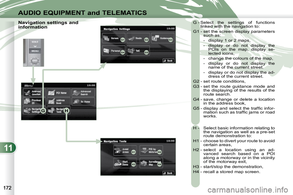
Navigation settings and
information G - Select the settings of functions
linked with the navigation to:
G1 - set the screen display parameters such as:
- display 1 or 2 maps,
- display or do not display the POIs on the map, display se-
lected icons,
- change the colours of the map,
- display or do not display the name of the current street.
- display or do not display the ad- dress of the current street.
G2 - set route conditions,
G3 - set the route guidance mode and the displaying of the results of the
route search.
G4 - save, change or delete a location in the address book,
� �G�5� �-� �d�i�s�p�l�a�y� �a�n�d� �s�e�l�e�c�t� �t�h�e� �t�r�a�f�fi� �c� �i�n�f�o�r�- �m�a�t�i�o�n� �s�u�c�h� �a�s� �t�r�a�f�fi� �c� �j�a�m�s� �o�r� �r�o�a�d�
works.
H - Select basic information relating to the navigation as well as a pre-set
route demonstration to:
H1 - choose to divert your route to avoid certain areas,
H2 - select a location using an ad- vanced search based on a POI
along a motorway or in the vicinity
of the motorway exit,
H3 - start/stop the demonstration,
H4 - recall a stored map screen.
Page 187 of 221
![PEUGEOT 4007 2007 Owners Manual 11
/
AUDIO EQUIPMENT and TELEMATICSEQUIPMENT and TELEMA
Entering an address and activating guidance (2/2) Press Explanations Result
Press [Street] and enter the name of a street using the to PEUGEOT 4007 2007 Owners Manual 11
/
AUDIO EQUIPMENT and TELEMATICSEQUIPMENT and TELEMA
Entering an address and activating guidance (2/2) Press Explanations Result
Press [Street] and enter the name of a street using the to](/manual-img/29/58326/w960_58326-186.png)
11
/
AUDIO EQUIPMENT and TELEMATICSEQUIPMENT and TELEMA
Entering an address and activating guidance (2/2) Press Explanations Result
Press [Street] and enter the name of a street using the touch keypad.
When a character of the name of the street is entered, if 5 streets or fewer
are recognised, you can select a street from a list which is displa yed or
press [List].
Press [House #] and enter the number of the house using the touch
keypad.
You can enter the name of a junction instead of the numb er
of the street. Press [Junction] and select the name from a
list which is displayed.
This is what you obtain once all of the information has b een entered:
If you agree with the information press [Set], otherwise press one of the
buttons to correct.
Press [Start] to start the navigation.
Page 192 of 221
11
AUDIO EQUIPMENT and TELEMATICS
General notes on CDs
Playing an audio CD When the audio CD is
inserted in the player,
playing of the tracks is
automatic and they can
be recorded onto the
hard disc.
Simultaneous access to the music
recognition service "Gracenote CDDB"
on the hard disc permits displaying of
the title information. Switching off the engine or removing
the CD during recording will result in the
tracks being faulty.
The operation of the navigation system
may slow down during recording.
The recording speed may be slower
than 4x due to the processing load on
the equipment or the condition of the
audio CD.
If jumps or other errors occur, return to
the beginning of the track and start the
recording again.
Even if there is no gap between the
tracks on the CD, a brief silence be-
tween tracks is stored on the hard disc. What is the Gracenote CDDB?
The title information for the
track currently being played
can be obtained from the
"Gracenote CDDB" database
stored on the hard disc.
The Gracenote company uses
this standard to identify the music and
the associated information such as:
- the title of the album,
- the name of the artist,
- the title of the tracks,
- the genre, …
For further details, consult the site:
www.gracenote.com.
The Gracenote CDDB database incorpo-
rated in this equipment cannot guarantee
the content of the data 100 %. You can
update this database using a DVD sold
separately.
Copyright
Your Audio equipment may allow you
to listen to music which is usually pro-
tected by copyright in accordance with
current national and international stan-
dards. Please consult these standards
and comply with them.
Recording onto the music
server
The tracks of audio CDs (not
MP3/WMA) can be recorded
onto the hard disc at approximately 4x
speed (e.g.: 60 minutes converted to
15 minutes) and stored on the music
server.
The sounds recorded may be altered
by the noise present and the quality of
the sound may differ from the original.
The tracks recorded on the music serv-
er cannot be reproduced on another
medium (CD-R/RW, HDD, etc...).
Previously recorded tracks cannot be
recorded again from the same CD.