2007 Acura MDX light
[x] Cancel search: lightPage 106 of 166
105Navigation System
System Set-up
I
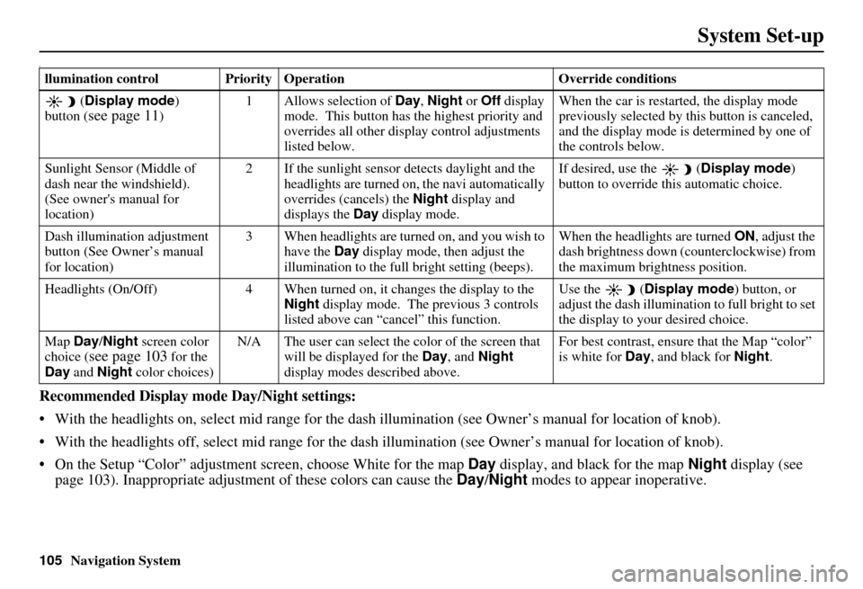
Recommended Display mode Day/Night settings:
With the headlights on, select mid range for the dash illumination (see Own er’s manual for location of knob).
With the headlights off, select mid range for the dash illumination (see Owner’s manual for location of knob).
On the Setup “Color” adjustment screen, choose White for the map Day display, and black for the map Night display (see
page 103). Inappropriate adjustment of these colors can cause the Day/Night modes to appear inoperative.
llumination control Priority Operation Override conditions
( Display mode )
button (
see page 11) 1 Allows selection of
Day, Night or Off display
mode. This button has the highest priority and
overrides all other displa y control adjustments
listed below. When the car is restarted, the display mode
previously selected by th
is button is canceled,
and the display mode is determined by one of
the controls below.
Sunlight Sensor (Middle of
dash near the windshield).
(See owner's manual for
location) 2 If the sunlight sensor
detects daylight and the
headlights are turned on, the navi automatically
overrides (cancels) the Night display and
displays the Day display mode. If desired, use the
(
Display mode )
button to override this automatic choice.
Dash illumination adjustment
button (See Owner’s manual
for location) 3 When headlights are turned on, and you wish to
have the Day display mode, then adjust the
illumination to the full bright setting (beeps). When the headlights are turned
ON, adjust the
dash brightness down (counterclockwise) from
the maximum brightness position.
Headlights (On/Off) 4 When turned on, it changes the display to the Night display mode. The previous 3 controls
listed above can “cancel” this function. Use the
(
Display mode ) button, or
adjust the dash illuminati on to full bright to set
the display to your desired choice.
Map Day/Night screen color
choice (
see page 103 for the
Day and Night color choices) N/A The user can select the color of the screen that
will be displayed for the Day, and Night
display modes described above. For best contrast
, ensure that the Map “color”
is white for Day, and black for Night.
Page 107 of 166

106Navigation System
System Set-up
To allow the Sunlight sensor to function properly, avoid blocking the sensor with loose articles (see Owner’s manual for
location of sensor).
Remember that once the
(Display mode ) button is selected, the other display mode controls are overridden until the
vehicle is restarted.
NOTE:
Loose articles in the center dash can block or interfere with th e operation of the sunlight sensor. See the MDX Owner’s manual
for additional information regardin g the dash brightness adjustment.
Page 109 of 166

108Navigation System
System Set-up
Rear View Camera Brightness
Adjustment
When in reverse, the Navi “hard”
buttons are locked out, except the
rotating portion of the Interface Dial
(knob). Rotate the knob clockwise to
make the camera image brighter, and
counterclockwise to darken the image.
This brightness adjustment is
independent of the screen brightness
adjustment in Setup.
NOTE:
The camera brightness cannot be adjusted by voice control.
Slight delays can occur when switching to the camera image, or
switching back to the map/menu
screen. This is normal.
Page 115 of 166

114Navigation System
Customer Assistance
Reporting Errors
Occasionally, you may encounter
database errors.
If the error pertains to freeways and main “verified” roads shown in black
on the map, then report it either
online at
http://update.navteq.com/, or to
Acura Customer Services.
If the error involves a light brown “unverified” road, then do not report
it. These areas have not been verified,
and are provided for reference only
(see Map Overview on page 6).
For errors in points of interest (POI), like a business that has changed their
name, do not report them. Keep in
mind that depending on when the data
was collected, and when your DVD
was purchased, the database can be
out of date. The business may have
not reported the change(s), or not be
in the database at all. Update
Navigation DVDs are available for
purchase, usually in the fall of each
year. If the error does not involve the
database, such as if the vehicle
position icon does not follow the
road, screen error messages, or other
GPS related errors, see Frequently
Asked Questions on page 128, System
Limitations on page 111 , or
Troubleshooting on page 136.
Acura Automobile Customer
Service
Telephone: (800) 382-2238
Fax: (310) 783-3535
Acura Navi
America Honda Motor Co., Inc.
Acura Client Services
MS 500-2N-7E
1919 Torrance Blvd.
Torrance, CA 90501-2746
If you desire more detailed information
on detailed map coverage, contact any
Acura dealer. Map coverage
information is at the Navigation DVD
order link, “ordering a Navigation
DVD” at: www.acura.com. The link is
found in “ACURA STORE.” Check the
“Coverage MAPS” link.
Page 130 of 166
Navigation System129
Frequently Asked Questions
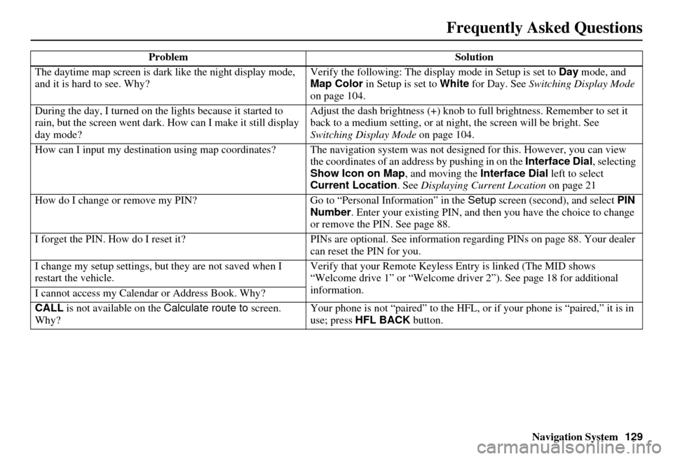
The daytime map screen is dark like the night display mode,
and it is hard to see. Why? Verify the following: The disp
lay mode in Setup is set to Day mode, and
Map Color in Setup is set to White for Day. See Switching Display Mode
on page 104.
During the day, I turned on the lights because it started to
rain, but the screen went dark. How can I make it still display
day mode? Adjust the dash brightness (+) knob to fu
ll brightness. Remember to set it
back to a medium setting, or at ni ght, the screen will be bright. See
Switching Display Mode on page 104.
How can I input my destination using map coordinates? The navigation system was not designed for this. However, you can view
the coordinates of an address by pushing in on the Interface Dial, selecting
Show Icon on Map , and moving the Interface Dial left to select
Current Location . See Displaying Current Location on page 21
How do I change or remove my PIN? Go to “Personal Information” in the Setup screen (second) , and select PIN
Number . Enter your existing PIN, and then you have the choice to change
or remove the PIN. See page 88.
I forget the PIN. How do I reset it? PINs are optional. See information regarding PINs on page 88. Your dealer
can reset the PIN for you.
I change my setup settings, bu t they are not saved when I
restart the vehicle. Verify that your Remote Keyless
Entry is linked (The MID shows
“Welcome drive 1” or “Welcome dr iver 2”). See page 18 for additional
information.
I cannot access my Calendar or Address Book. Why?
CALL is not available on the Calculate route to screen.
Why? Your phone is not “paired” to the HFL,
or if your phone is “paired,” it is in
use; press HFL BACK button.
Problem
Solution
Page 132 of 166
Navigation System131
Frequently Asked Questions
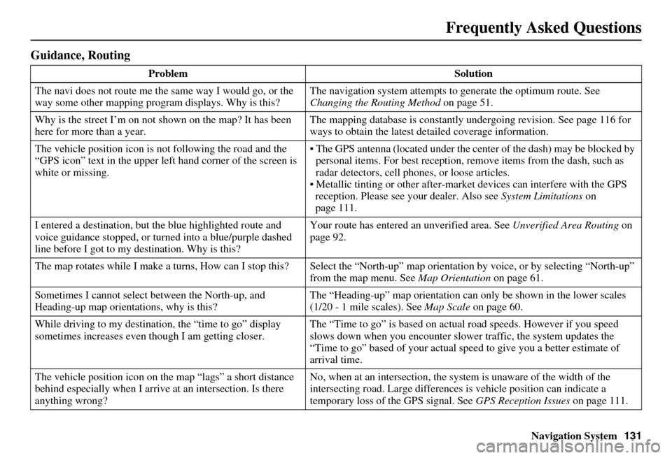
Guidance, Routing
Problem Solution
The navi does not route me the same way I would go, or the
way some other mapping progr am displays. Why is this? The navigation system attempts to
generate the optimum route. See
Changing the Routing Method on page 51.
Why is the street I’m on not shown on the map? It has been
here for more than a year. The mapping database is
constantly undergoing revision. See page 116 for
ways to obtain the latest de tailed coverage information.
The vehicle position icon is not following the road and the
“GPS icon” text in the upper left hand corner of the screen is
white or missing. The GPS antenna (located under the center of the dash) may be blocked by
personal items. For best reception, remove items from the dash, such as
radar detectors, cell phone s, or loose articles.
Metallic tinting or other after-marke t devices can interfere with the GPS
reception. Please see your dealer. Also see System Limitations on
page 111.
I entered a destination, but th e blue highlighted route and
voice guidance stopped, or turned into a blue/purple dashed
line before I got to my destination. Why is this? Your route has entered
an unverified area. See Unverified Area Routing on
page 92.
The map rotates while I make a turns, How can I stop this? Select the “North-up” map orientation by voice, or by selecting “North-up”
from the map menu. See Map Orientation on page 61.
Sometimes I cannot select between the North-up, and
Heading-up map orientations, why is this? The “Heading-up” map orientation can
only be shown in the lower scales
(1/20 - 1 mile scales). See Map Scale on page 60.
While driving to my destinati on, the “time to go” display
sometimes increases even though I am getting closer. The “Time to go” is based on actual
road speeds. However if you speed
slows down when you encounter slower traffic, the system updates the
“Time to go” based of your actual spee d to give you a better estimate of
arrival time.
The vehicle position icon on the map “lags” a short distance
behind especially when I arrive at an intersection. Is there
anything wrong? No, when at an intersection, the syst
em is unaware of the width of the
intersecting road. Large differences is vehicle position can indicate a
temporary loss of the GPS signal. See GPS Reception Issues on page 111.
Page 136 of 166
Navigation System135
Frequently Asked Questions
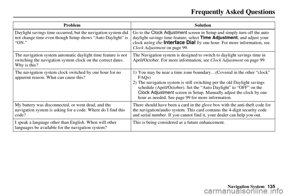
Daylight savings time occurred, but the navigation system did
not change time even though Setup shows “Auto Daylight” is
“ON.” Go to the Clock Adjustment
screen in Setup and simply turn off the auto
daylight savings time feature, select Time Adjustment , and adjust your
clock
using the Interface Dial by one hour. For more information, see
Clock Adjustment on page 99.
The navigation system automatic daylight time feature is not
switching the navigation system clock on the correct dates.
Why is this? The Navigation system is designed to
switch to daylight savings time in
April/October. For more information, see Clock Adjustment on page 99.
The navigation system clock switched by one hour for no
apparent reason. Wh at can cause this? 1) You may be near a ti
me zone boundary…(Covered in the other “clock”
FAQs)
2) The navigation system is still swit ching per the old Daylight savings
schedule (April/October). Set the “Auto Daylight” to “OFF” on the
Clock Adjustment screen in Setup. Manually adjust the clock by one
hour as needed. See page 99 for more information.
My battery was disconnected, or went dead, and the
navigation system is asking for a code. Where do I find this
code? There should have been a card in the
glove box with the anti-theft code for
the navigation/audio system. This card contains the 4-digit security code
and serial number. If you cannot find it, your de aler can help you out.
I speak a language other than English. When will other
languages be available fo r the navigation system? This is being considered
as a future enhancement.
Problem Solution
Page 139 of 166
138Navigation System
Glossary
Initialization - This refers to the period
needed to reacquire the GPS satellite
orbital information whenever the
navigation system power has been
disconnected. This can take 10 to 45
minutes with the ve hicle out in an
open area.
Instant Fuel - The current
instantaneous fuel economy value as
displayed by the Trip computer
screen.
LCD - Liquid Crystal Display. The
navigation screen.
Map Matching - The received GPS information allows the navigation
system to position the vehicle on the
map. Map matching has occurred if
the map screen is displaying the
current street name in the bottom-
shaded area.
Mic - Abbreviation for the microphone
used for receiving voice commands.
It is located near the map light in the
ceiling.
Multi-Information Display (MID) - Located in the gauge assembly. See
the Owner’s manual for additional
information. MW -
Maneuver Window. While on-
route to a destination, this window
displays information about the next
maneuver.
Navi - Abbreviation for the navigation
system.
North Pointer - The map symbol
showing the map orientation. See
page 61.
Off Route - This occurs when the user
leaves mapped roads. Off road
tracking dots (“breadcrumbs”) are
displayed if the option is enabled in
the Setup screen. The user can use
them to return to a mapped road. The
bottom of the navigation screen will
say “Not on a digitized road”
Outlying Areas - These are rural areas
that typically have only their main
roads mapped. All other roads are
shown in light brown for reference
only, since they have not been
verified.
PIN - Personal Identification Number.
A random 4-digit number created by
the customer to protect personal
information. POI -
Point Of Interest. These are the
businesses, schools etc. found under
the Places option on the Enter
destination by screen. See page 51.
Polygon - Colored areas on the map
screen denoting parks, schools etc.
See Map Screen “features” for a list
of the assigned colors. See page 51.
Reminder - Automatic “pop-up”
Calendar message. See Calendar on
page 78.
Remote Keyless Entry - Allows you to
lock/unlock the doors, unlock the
tailgate, and link/ unlink Driver 1/
Driver 2 settings.
RES - Rear Entertainment System.
(Factory installed)
Security Code - Code needed to
activate the navigation system or
audio system. See Entering the
Security Code on page 109.