Page 352 of 364

Setu
1
Open th
screen
�How to
asE
J
ME
ENT
ENT
30
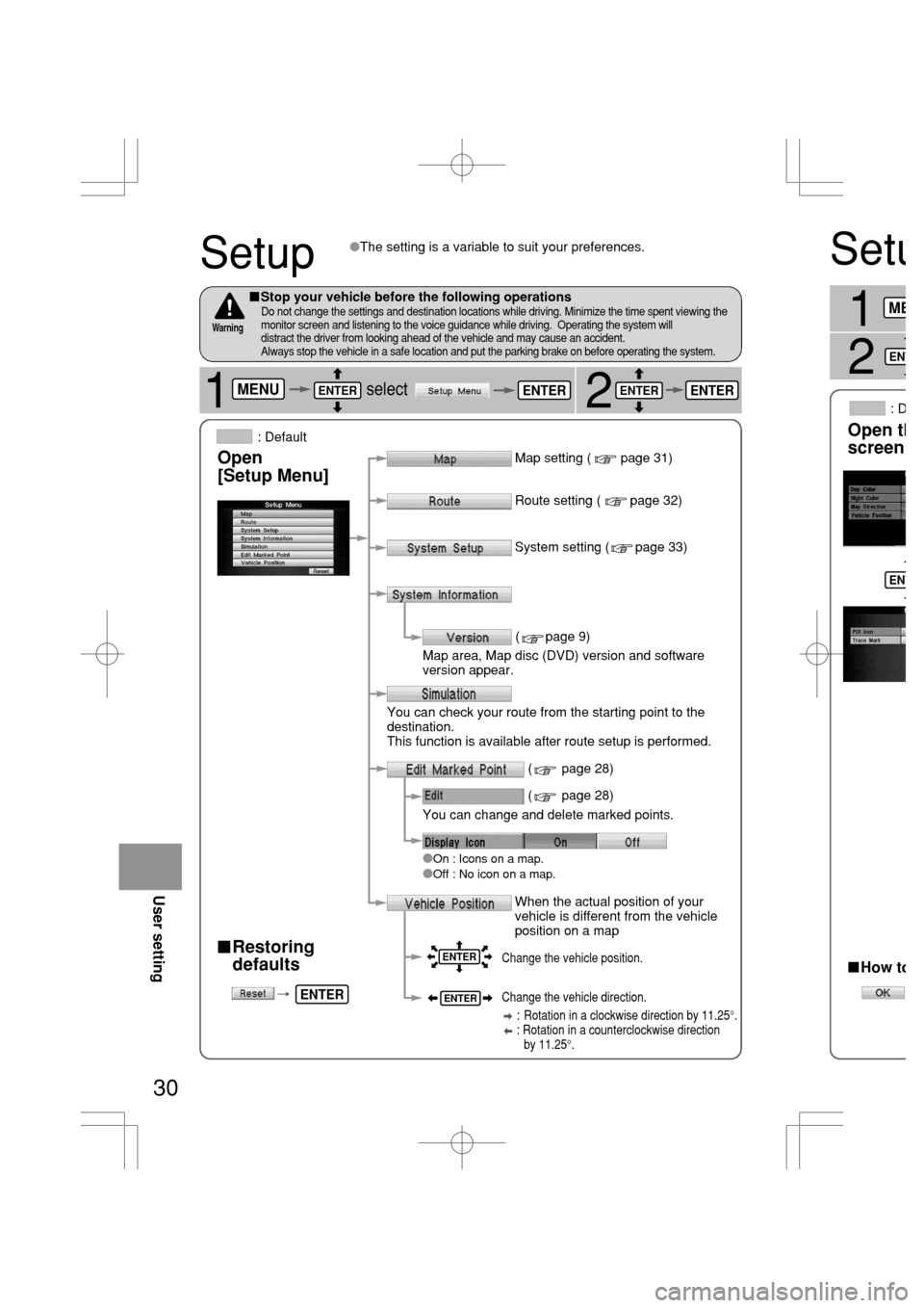
Setup
2
�Restoring
defaults
Map setting ( page 31)
�
On : Icons on a map.�Off : No icon on a map.
�The setting is a variable to suit your preferences.
Route setting ( page 32)
System setting ( page 33)
( page 9)
Map area, Map disc (DVD) version and software
version appear.
You can check your route from the starting point to the
destination.
This function is available after route setup is performed.
You can change and delete marked points.
( page 28)
( page 28)
Change the vehicle position.
Change the vehicle direction.
: Rotation in a clockwise direction by 11.25°.
: Rotation in a counterclockwise direction
by 11.25°.
�Stop your vehicle before the following operationsDo not change the settings and destination locations while driving. Minimize the time spent viewing the
monitor screen and listening to the voice guidance while driving. Operating the system will
distract the driver from looking ahead of the vehicle and may cause an accident.
Always stop the vehicle in a safe location and put the parking brake on before operating the system.
Warning
Open
[Setup Menu]
When the actual position of your
vehicle is different from the vehicle
position on a mapUser setting
: Default
1selectMENUENTERENTERENTER
ENTER
ENTER
ENTER
ENTER
Page 355 of 364
![MAZDA MODEL RX 8 2005 Owners Manual (in English) 33
Open the
[System Setup]
screen�Volume control (5 levels)
�Beep
�On : Beep activated when pressing buttons in the
remote control.
�Off : Beep inactivated when pressing buttons in the
remote control. MAZDA MODEL RX 8 2005 Owners Manual (in English) 33
Open the
[System Setup]
screen�Volume control (5 levels)
�Beep
�On : Beep activated when pressing buttons in the
remote control.
�Off : Beep inactivated when pressing buttons in the
remote control.](/manual-img/28/15614/w960_15614-354.png)
33
Open the
[System Setup]
screen�Volume control (5 levels)
�Beep
�On : Beep activated when pressing buttons in the
remote control.
�Off : Beep inactivated when pressing buttons in the
remote control.
�On : Activates voice feedback.�Off : Cancels voice feedback.
�Language
�Changeover meter/mile
�Metric : Meters�English : Miles
�Voice Feedback*
�Clock
: Default
�How to exit
�Daylight Saving Time(Summer Time)
�On : Daylight saving time mode is enabled.
(The navigation internal clock gains 1 hour).
�Off : Daylight saving time mode is disabled.
SetupSystem
User setting
1
2select3
selectMENUENTER
ENTER
ENTER
ENTERENTER
ENTER
ENTER
ENTER
Sets the volume for voice guidance and voice feedback*.
When the volume is set to 0, the voice is turned off.
* The operation status is announced by voice.
(e.g. changing the map orientation, starting or terminating
the route calculation, staring or terminating the simulation,
displaying the maneuver list.)
nt go back
om it.
atically
proaching
ENTER
Page 356 of 364

�If you are u
takes about
position.
�The GPS sa
lower positi
�There may
turning on t
�GPS sign
In tunnels
This functio
disc, applies
and displays
�Intelligent m
in vehicle p
�Using a spa
�Any differen
on the map
34
Precautions/System Performance
Second branching pointFirst branching point150m
100m
Route
In 700m left turn.Left turn ahead,
then right turn.
Voice guidance has the following functions:
When two intersections are close together,
the voice guidance may be late.
Roundabout.
Take the second
exit.
GRrfsoMesTePfNOmePo sOTrsASe rsoe/roRrTU
oRrsQeIArs/PINOfArs.eTsoRrs rAefNsVOWsmrsSOorZ
�The system voice announces the distance to an upcoming turn and the turning direction.aThis guidance function is automatic. Therefore, you do not have to set it, and it cannot
be disabled.
�Intersection guidance
Voice Guidance
�The navigation system is just a support system for the driver. The driver should always
pay attention to the traffic situation to safely make decisions. You may be unable at
times to arrive at your destination due to out-of-date information on a map disc. You
should be especially careful when selecting an urgent destination such as a hospital or
a police station.
�Your route may sometimes include roads that are not open to vehicles or are closed
due to traffic regulations. Please comply with the local traffic regulations.
�Do not change the settings and destination locations while driving. Minimize the time
spent viewing the monitor screen and listening to the voice guidance while driving.
Operating the system will distract the driver from looking ahead of the vehicle and may
cause an accident. Always stop the vehicle in a safe location and use the parking brake
before operating the system.
Warnings
�The system vocally announces the distance to an upcoming highway
branching point or junction.
aThis guidance function can be set in the [Setup menu]. For details, see page 32.
�The mobile navigation system calculates and indicates the vehicle position on the map by
multiplying the speed pulse emitted by the vehicle with a correction coefficient.
The speed pulse emitted varies with the type of vehicle and with differences in tire
pressure and wear.
A different correction coefficient might even be required for the same type of vehicle.
�Using a spare tire in place of the regular one may cause vehicle position deviations.
Automatic Distance Correction
As necessary
Page:
< prev 1-8 9-16 17-24